August 25 Webinar to Highlight How Analysis of Lidar and Historical Data Can Help Electric Utilities Improve Reliability and Reduce Costs by Identifying Areas for Proactive Trimming and Removal
Climate change widespread, rapid, and intensifying – IPCC

GENEVA, Aug 9 – Scientists are observing changes in the Earth’s climate in every region and across the whole climate system, according to the latest Intergovernmental Panel on Climate Change (IPCC) Report, released today.
Maxar Satellite Imagery: Dixie Fire, California
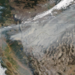
Maxar collected new satellite images on Sunday, August 8th of northern California and the Dixie wildfire that continues to burn and has become the state’s second largest wildfire in history.
Complimentary World LNG Map at Gastech 2021 and World Gas Conference (WGC 2022) by Mudrock Media

KUALA LUMPUR, Malaysia–Mudrock Media will present at Gastech 2021 exhibition, the first major energy event to take place live & in-person from September 21-23, 2021 at Dubai World Trade Centre, United Arab Emirates, and the 28th World Gas Conference (WGC2022) from May 23-27, 2022 in Daegu, South Korea. Mudrock Media will hand out 3,000 complimentary […]
AccuWeather Launches Digital Hurricane Tracker In App and Online to Coincide with Above-Normal 2021 Hurricane Season

Innovative hurricane tracking feature brings most comprehensive hurricane information available to increase awareness of incoming hurricanes and their impacts, displaying exclusive AccuWeather Forecast Eye Path maps, impact graphics and easily navigable tools to track and follow storms for optimal preparation protection and insight.
Clear Seas Launches Interactive Mapping Dashboard That Visualizes Marine Shipping Safety in Canada

VANCOUVER, British Columbia–An online dashboard developed by the Clear Seas Centre for Responsible Marine Shipping (Clear Seas) provides a comprehensive, first-of-its-kind publicly available picture of marine shipping incidents and accidents in and around Canadian waters.
Esri Releases New Predictive 2050 Global Land Cover Map

Clark Labs Joins Esri to Deliver Map to Worldwide Users Showing 30 Year Projected Change
Flagship Innovation Contest Draws Students From 47 Countries to Solve Water Challenges
Xylem Engages First 1,700 Students in Global Youth Program: Xylem Ignite
Esri Releases Book That Is a Call to Action for Conservation

A Guide for Modern Strategies to Achieve Environmental Equity and Sustainability
Tidal Monitoring at the Port of Waterford
OceanWise are proud to announce a recent contract win with the Port of Waterford to help with their aim to consolidate, manage and better share environmental data collected by a diverse range of environmental sensors across their port jurisdiction.