GIS user technology news

News, Business, AI, Technology, IOS, Android, Google, Mobile, GIS, Crypto Currency, Economics

  • Advertising & Sponsored Posts
    • Advertising & Sponsored Posts
    • Submit Press
  • PRESS
    • Submit PR
    • Top Press
    • Business
    • Software
    • Hardware
    • UAV News
    • Mobile Technology
  • FEATURES
    • Around the Web
    • Social Media Features
    • EXPERTS & Guests
    • Tips
    • Infographics
  • Blog
  • Events
  • Shop
  • Tradepubs
  • CAREERS
You are here: Home / Archives for * PRESS / Earth Imaging - Remote Sensing

Imagery, earth imaging and remote sensing

NASA’s Webb Telescope Launches to See First Galaxies, Distant Worlds

December 27, 2021 By GISuser

WASHINGTON, Dec. 25, 2021  — NASA’s James Webb Space Telescope launched at 7:20 a.m. EST Saturday on an Ariane 5 rocket from Europe’s Spaceport in French Guiana, South America.

Filed Under: Business, Earth Imaging - Remote Sensing Tagged With: NASA

PASCO to distribute Pléiades Neo satellite imagery

December 16, 2021 By GISuser

Toulouse, 16 December 2021 – Airbus and Japanese geospatial solutions provider PASCO CORPORATION (hereinafter PASCO) have signed a new partnership agreement for a Pléiades Neo Direct Receiving Station (DRS) with associated data distribution rights on the Japanese market.

Filed Under: Earth Imaging - Remote Sensing

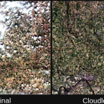
UP42 Announces Thetaspace as Copernicus Masters Challenge Winner with Solution to Cloud Cover in EO Data
December 15, 2021 By GISuser

CloudlessEO Algorithm Fills in Clouds and Shadows in Optical Satellite Imagery

CloudlessEO Algorithm Fills in Clouds and Shadows in Optical Satellite Imagery

Filed Under: Business, Earth Imaging - Remote Sensing, Featured TOP PR, Top Press Tagged With: UP42

NASA Expands its Commercial Data Acquisition Program with Airbus

December 3, 2021 By GISuser

Herndon, Virginia, USA. DD September 2021 – NASA has expanded the Commercial Smallsat Data Acquisition Program (CSDAP) to include Airbus as the first radar data provider to NASA’s community of researchers and scientists for evaluation to determine the utility for advancing NASA’s science and application goals. Airbus will provide them with a comprehensive catalog of Synthetic […]

Filed Under: Business, Earth Imaging - Remote Sensing

UP42 Joins the BDI NewSpace Initiative on Its Mission to Foster the German Economy and Innovation

December 1, 2021 By GISuser

The Berlin-based geospatial start-up becomes an official member of the Federation of German Industries (BDI) along with other key players in the space industry.

Filed Under: Business, Earth Imaging - Remote Sensing

BlackSky delivers first insights in 14 hours of launch

November 23, 2021 By GISuser

BlackSky On Track to Significantly Expand its Constellation this Year Meeting an Expanding Demand for Real-time Global Intelligence

Filed Under: DATA, Earth Imaging - Remote Sensing Tagged With: blacksky

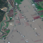
Maxar Satellite Imagery: Flooding Along Fraser River, British Columbia
November 23, 2021 By GISuser

Maxar collected new satellite imagery on Friday (November 19th) of the ongoing flooding in Sumas Prairie to the east of Abbotsford, British Columbia, Canada. Highways, roads and many buildings and farms remain under water.

Filed Under: Earth Imaging - Remote Sensing, Emergency Response, Top Text Lead Story Tagged With: flood, Imagery, maxar

Aerial vs. Satellite: How to Choose the Best Imagery Type

November 18, 2021 By GISuser

Remote sensing methods are methods of studying the Earth and other space bodies from air or spacecraft with the help of aerial photography and satellite imagery. Satellite and aerial imagery help explore landscapes, analyze the scale of human impact on the environment, and find inspiration in the mesmerizing textures, shapes, and patterns on the planet’s […]

Filed Under: Earth Imaging - Remote Sensing Tagged With: Satellite Imagery

AerialSphere Joins the Esri ArcGIS Marketplace with a Nationwide Dataset of 360-Degree Imagery for ArcGIS

November 13, 2021 By GISuser

Aerialsphere on the ArcGIS Marketplace

PHOENIX, Ariz. – November 8, 2021, AerialSphere, the only company to combine 360-degree aerial imagery with location data, today announced that they have made their nationwide dataset of 360-degree imagery available through the ArcGIS Marketplace. AerialSphere also announced they have earned Silver level partner status within the Esri Partner Network (EPN).

Filed Under: Earth Imaging - Remote Sensing, Software, Top Press Tagged With: aerialsphere, arcgis, ESRI, Imagery

UP42 Unveils Very High-Resolution Imagery from Airbus Pléiades Neo Satellites

November 10, 2021 By GISuser

Enhancing Applications in Utilities, Insurance, Agriculture, Government

Filed Under: Business, Earth Imaging - Remote Sensing, Top Text Lead Story Tagged With: UP42

« Previous Page
Next Page »

Top Press

The Global Expansion of Aueshah: A New Era of High Jewelry

April 11, 2026 By GISuser

KARACHI, PAKISTAN. The international luxury market is experiencing a profound shift. Consumers are increasingly rejecting mass-produced goods in favor of rarity, authenticity, and emotional depth. … [Read More...]

State of Data Science Report – AI and Open Source at Work

September 10, 2025 By GISuser

AI and Open Source at Work … [Read More...]

Topcon Announces Landmark Expansion of Topnet Live Network Across USA

January 26, 2025 By GISuser

LIVERMORE, Calif.---Topcon Positioning Systems has announced a significant expansion of its Topnet Live reference station network, introducing 200 new geodetic stations strategically positioned across … [Read More...]

Space Flight Laboratory (SFL) Announces Launch and Deployment of NorSat-4 Maritime Monitoring Microsatellite

January 19, 2025 By GISuser

Seventh Satellite Developed by SFL for Norway … [Read More...]

HERE and BMW Group extend partnership on AI-powered mapping system

January 8, 2025 By GISuser

HERE and BMW Group extend partnership on AI-powered mapping system for automated driving and enhanced road safety … [Read More...]

Everest Base Camp Helicopter Tour, Helicopter Return Trek, and Manaslu Circuit Trek: Which Nepal Adventure Is Right for You?

November 6, 2026 By GISuser

Almost everyone planning a Nepal trip runs into the same wall. You want the big mountains, you have a fixed number of days, and every itinerary you read seems to promise something … [Read More...]

SFL Missions Inc. Confirms Successful Deployment of Six HawkEye 360 Radio Frequency Detection Satellites with Advanced Capabilities

October 27, 2026 By GISuser

MĀHIA, New Zealand, 26 October 2026 – SFL Missions Inc. today confirmed the successful deployment of six radio frequency (RF) detection and geolocation satellites for HawkEye 360 … [Read More...]

Canadian-Built RoadEng 12 Uses AI to Find the Best Location for New Resource and Rural Roads

October 17, 2026 By GISuser

Vancouver, BC, Canada, October 15, 2026 – North Vancouver-based Softree Technical Systems today released RoadEng Version 12, used in more than 75 countries to locate and design … [Read More...]

Beyond the Map: How AI Image and Video Generation Is Changing Geospatial Communication

October 14, 2026 By GISuser

Ask anyone who has shipped a GIS project what the hardest part was, and the answer is rarely the spatial analysis. It is almost always the communication. A site suitability … [Read More...]

From Maternity to Everyday Wear: Building a Wardrobe That Grows With You

October 14, 2026 By GISuser

When I think about maternity clothing, I feel the biggest mistake is buying too many things at once. During pregnancy, your body keeps changing, and something that fits well today … [Read More...]

Copyright gletham Communications 2015 - 2026

Go to mobile version