Via FastCompany… How SpaceX, Planet Labs, Relativity Space, the Johns Hopkins University Applied Physics Laboratory, and more are leading the orbital economy.
Imagery, earth imaging and remote sensing
Maxar Satellite Imagery: Mass grave found in Bucha, Ukraine

A mass grave has been identified in the town of Bucha, Ukraine, northwest of the capital of Kyiv.
Maxar Satellite Imagery: Ukraine, March 18-21, 2022 reveals continued Russian military activity
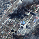
New Maxar satellite imagery (March 18-21, 2022) reveals continued Russian military activity in and around a number of key Ukrainian cities including Mariupol, Kyiv, and Chernihiv.
UP42 Partners with Near Space Labs to Offer Very High-Resolution Imagery using Zero-Emission Balloons
Empowering Geospatial Organizations with Sustainable Earth Observation Technology
Airbus to Provide Imagery Services That Enable Intelinair’s Crop Analytics Platform
HERNDON, Va. & INDIANAPOLIS–(BUSINESS WIRE)–Intelinair and Airbus announced today a multi-year collaboration agreement that will provide high-resolution Airbus satellite imagery as an input to Intelinair’s artificial intelligence (AI) powered crop analytics AGMRI® platform to deliver a complete view of every acre, every field from planting to harvest.
L3Harris High-Resolution Weather Instrument Set to Launch March 1 on NOAA’s GOES-T Satellite
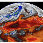
MELBOURNE, Fla.–L3Harris Technologies’ (NYSE:LHX) third high-resolution weather instrument is set to launch March 1 onboard a NOAA satellite – strengthening the nation’s ability to monitor the environment and rapidly detect severe weather.
Airbus to provide imagery services that enable IntelinAir’s crop analytics platform

Herndon, Va. and Indianapolis, 23 February 2022 – IntelinAir and Airbus announced today a multi-year collaboration agreement that will provide high-resolution, Airbus satellite imagery as an input to IntelinAir’s artificial intelligence (AI) powered crop analytics AGMRI™ platform to deliver a complete view of every acre, every field from planting to harvest.
LAND INFO Announces Updated 10m USA Countrywide
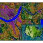
Land Use Land Cover Mapping Dataset
Phase One Unveils Wide-Area, 120MP Aerial Camera with Global Shutter Sensor Technology

Designed for National Security, Geospatial Intelligence, Search & Rescue Applications
Maxar Reserves May 15 – June 13 Window for First WorldView Legion Launch

WESTMINSTER, Colo.–(BUSINESS WIRE)–Maxar Technologies (NYSE:MAXR) (TSX:MAXR), provider of comprehensive space solutions and secure, precise, geospatial intelligence, today announces it has reserved a window of May 15, 2022 – June 13, 2022 with SpaceX to launch the first two WorldView Legion satellites.