
Matrox and BrightSign are ready for deployment
Teledyne announces new Ladybug6 cameras for high accuracy 360-degree spherical image capture

Richmond, CANADA ─ October 17, 2022 ─ Teledyne FLIR Integrated Imaging Solutions is pleased to announce the all new Ladybug6— the latest addition to its field proven Ladybug series. Ladybug6 is the leading high-resolution camera designed to capture 360-degree spherical images from moving platforms in all-weather conditions. Its industrial grade design and out-of-the-box factory calibration produces 72 […]
Mosaic Announces Integration of High Resolution 360º Camera with Laser Scanning Solutions

October 10, 2022 – Ready for release – Mosaic X high resolution cameras, enabling customers to gather more valuable data with their mobile mapping solutions, now compatible with RIEGL’s line of Mobile Laser Scanning Systems.
UP42 Adds BlackSky Dynamic Monitoring to Marketplace

On-demand access to low-latency dawn-to-dusk imagery
How to Prepare Students for the Manufacturing and Engineering Jobs of Tomorrow

Technology used in manufacturing and engineering is changing so quickly that industry is having a hard time finding workers with the necessary skill sets. In fact, new research shows that 30% of workers with mid-level skills will be obsolete by 2030.
Apple Provides Developers with Even More Powerful Technologies to Push the App Experience Forward

New APIs offer deeper platform integration and greater capabilities for third-party apps
Maxar Satellite Imagery: Mass grave found in Bucha, Ukraine

A mass grave has been identified in the town of Bucha, Ukraine, northwest of the capital of Kyiv.
New Esri Book Provides Beginners a Guide for Location Analytics

Getting to Know ArcGIS Pro 2.8 Shows New Users How to Make Sense of Data with GIS
UP42 Announces Thetaspace as Copernicus Masters Challenge Winner with Solution to Cloud Cover in EO Data
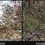
CloudlessEO Algorithm Fills in Clouds and Shadows in Optical Satellite Imagery
Virtual Surveyor Provides Comprehensive Insights into Drone Survey Data with Addition of Profile View
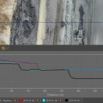
AARSCHOT, Belgium, 17 November 2021 – With the goal of giving surveyors a better understanding of the topographic data captured by drone mapping sensors, Virtual Surveyor has unveiled Profile View functionality in Version 8.4 of its popular surveying software. Profile View enables users to generate an elevation profile simply by drawing an onscreen traverse across any […]