GIS user technology news

News, Business, AI, Technology, IOS, Android, Google, Mobile, GIS, Crypto Currency, Economics

  • Advertising & Sponsored Posts
    • Advertising & Sponsored Posts
    • Submit Press
  • PRESS
    • Submit PR
    • Top Press
    • Business
    • Software
    • Hardware
    • UAV News
    • Mobile Technology
  • FEATURES
    • Around the Web
    • Social Media Features
    • EXPERTS & Guests
    • Tips
    • Infographics
  • Blog
  • Events
  • Shop
  • Tradepubs
  • CAREERS
You are here: Home / Archives for Ukraine

Draganfly Fulfills Delivery of First Situational Assessment Drone for DSNS Emergency Services Department Ukraine

February 17, 2023 By GISuser

Draganfly’s Situational Assessment Drones will provide regions of Ukraine with intel, infrastructure assessments, and aid in search and rescue operations throughout the country.

Filed Under: UAV/UAS Tagged With: UAV, Ukraine

Dedrone Launches DedronePortable for Military and Commercial Entities Around the World

August 2, 2022 By GISuser

Already purchased for the Ukrainian military, DedronePortable offers easy-to-use, mobile and agile drone response with optional mitigation, and setup in less than 20 minutes

Filed Under: UAV/UAS Tagged With: drone, UAV, Ukraine

Draganfly Deploys Versatile Situational Assessment Drones to Ukraine

June 14, 2022 By GISuser

Draganfly has successfully completed deployment and training of its initial Situational Assessment Drones in Ukraine

Filed Under: Business, UAV/UAS Tagged With: UAV, Ukraine

Maxar satellite imagery: Second cemetery in Mariupol area identified with new excavations

April 23, 2022 By GISuser

Recent Maxar high-resolution satellite imagery of the Mariupol area reveals the existence of a second cemetery that has expanded over the past month and includes several long trenches that are/will likely become new grave sites.

Filed Under: Earth Imaging - Remote Sensing, Top Press Tagged With: Satellite Imagery, Ukraine

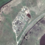
Maxar Satellite Imagery: Mass grave found in Bucha, Ukraine

April 5, 2022 By GISuser

A mass grave has been identified in the town of Bucha, Ukraine, northwest of the capital of Kyiv.

Filed Under: Earth Imaging - Remote Sensing, Featured TOP PR Tagged With: maxar, sattelite, Ukraine

Exclusive New Title from East View: Terrain Analysis of Ukraine

November 3, 2014 By GISuser

Minneapolis, MN, USA. November 1, 2014 — East View Press is proud to announce the latest addition to its series of Terrain Analysis books, the Terrain Analysis of Ukraine. Available in e-book and print, the Terrain Analysis of Ukrainedelivers a descriptive and visual geographic knowledge base of Ukraine’s population, roads, topography and soils, hydrology, vegetation and climate.

Filed Under: Business Tagged With: Ukraine

Recent Industry News

The Drift Between Early Notes and Final Case Files in Abuse-Related Legal Support

April 29, 2026 By GISuser

Aerial Surveys Int’l and Global Marketing Insights to Present GEOINT 2026 Workshop on Multi-Domain Geospatial Fusion for Automated Infrastructure Monitoring

April 24, 2026 By GISuser

Why Timing Matters More Than You Think With Spray Seal (And Why People Often Get It Slightly Wrong)

April 22, 2026 By GISuser

The Quiet Planning Stage Most People Don’t See When Building a Pool in Brisbane

April 22, 2026 By GISuser

Hot News

State of Data Science Report – AI and Open Source at Work

HERE and AWS Collaborate on New HERE AI Mapping Solutions

Virtual Surveyor Adds Productivity Tools to Mid-Level Smart Drone Surveying Software Plan

Categories

Copyright gletham Communications 2015 - 2026

Go to mobile version