GIS user technology news

News, Business, AI, Technology, IOS, Android, Google, Mobile, GIS, Crypto Currency, Economics

  • Advertising & Sponsored Posts
    • Advertising & Sponsored Posts
    • Submit Press
  • PRESS
    • Submit PR
    • Top Press
    • Business
    • Software
    • Hardware
    • UAV News
    • Mobile Technology
  • FEATURES
    • Around the Web
    • Social Media Features
    • EXPERTS & Guests
    • Tips
    • Infographics
  • Blog
  • Events
  • Shop
  • Tradepubs
  • CAREERS
You are here: Home / Archives for *FEATURES / SPATIAL MEDIA AUTHORS

A User Review of Trimble® Catalyst™

March 12, 2018 By Guest

GEO Jobe UAV and Aerial Mapping Services (geo-jobe.com/uav) shares its insights

Filed Under: EXPERTS, Mobile, SPATIAL MEDIA AUTHORS, Top Features, Top Text Lead Story Tagged With: catalyst, GNSS, GPS, mobile, review, Trimble, Trimble Catalyst

LidarMag Feature – GIS Mapping Services are on the Cutting Edge with UAV Collected Imagery

August 7, 2017 By GISuser

lidarmag

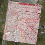
The GIS mapping services division of GEO Jobe has been quite active with UAV technology over the last year. We’ve turned to cutting edge hardware and software solutions to take to the sky and support some of our existing clients (and new ones) with imagery & analysis derived from UAV (drone) data acquisition.

Filed Under: LiDAR, Mobile, SPATIAL MEDIA AUTHORS, Top Features, UAV/UAS Tagged With: geo jobe, lidar, suas, UAV

Feature – LiDAR and Imagery is Now Widely Used for Airport Mapping

June 6, 2016 By GISuser

LiDAR and Imagery is Now Widely Used for Airport Mapping

This interesting story comes to us via LiDAR Magazine… LiDAR and Imagery is Now Widely Used for Airport Mapping – In FY 2007, the FAA issued three Advisory Circulars to provide guidance for the collection and submission of aeronautical data and to identify the FAA’s GIS data model for airport-related data.

Filed Under: *FEATURES, LiDAR, SPATIAL MEDIA AUTHORS, Top Features Tagged With: airport map, lidar

Feature – LiDAR and Imagery is Now Widely Used for Airport Mapping

May 30, 2016 By GISuser

Via our partner site at LiDAR Magazine… In FY 2007, the FAA issued three Advisory Circulars to provide guidance for the collection and submission of aeronautical data and to identify the FAA’s GIS data model for airport-related data.

Filed Under: *FEATURES, EXPERTS, LiDAR, SPATIAL MEDIA AUTHORS, Top Features

Trimble Revolutionizes Mobile Mapping with MX2 Portable Mobile Mapping System on a Boat

May 25, 2016 By GISuser

AllTerra Deutschland GmbH is the Trimble Center of Competence for Northern and Eastern Germany, and represents Trimble´s Geospatial, Marine and GIS divisions in the region using their mobile mapping solutions as well as all sorts of Geospatial products for several years on various projects all around Germany.

Filed Under: LiDAR, SPATIAL MEDIA AUTHORS, Top Press Tagged With: lidar, Mobile Mapping, Trimble

Feature – The Sharing Economy and Its Place in Geospatial Services

March 18, 2016 By GISuser

A feature of interest from LiDAR Magazine looks at the topic of the sharing economy and geospatial services.

Filed Under: *FEATURES, Around the Web, Business, SPATIAL MEDIA AUTHORS, Top Features Tagged With: sharing economy

Software, Fieldwork Pay Off for Geomatics Students

February 15, 2016 By GISuser

From the recent American Surveyor Magazine…

Filed Under: EDU, SPATIAL MEDIA AUTHORS

Event Review, Commercial Drone Expo

November 19, 2015 By GISuser

I was invited to come and take a look at the industries latest conference for drones. Spar group, long known as a provider of quality trade shows did not disappoint with this inaugural event. The UAV Expo was held in Las Vegas October 5-7.

Filed Under: *FEATURES, Events, Featured Event, FrontPage Leader, GISuser Promotion, SPATIAL MEDIA AUTHORS, Top Features, Top Press, UAV/UAS Tagged With: Commercial Drone Expo, UAV

LiDAR Feature – Random Points: Drones and LiDAR

February 19, 2015 By GISuser

A special LiDAR feature contribution from the February 2015 edition of LiDAR Magazine…

Filed Under: **Front Page, LiDAR, SPATIAL MEDIA AUTHORS, Top Features, UAV/UAS Tagged With: 3D, drones, lidar, point cloud

Event Feature – Review of Trimble Dimensions 2014

December 17, 2014 By GISuser

I attended, as well as presented at Trimble Dimensions this year. More than 4,200 professionals from 83 countries took in the seventh edition of this conference. A good increase over the 3,500 from the event’s last gathering two years ago.

Filed Under: *FEATURES, Events, SPATIAL MEDIA AUTHORS Tagged With: Trimble Dimensions

Next Page »

Recent Industry News

The Drift Between Early Notes and Final Case Files in Abuse-Related Legal Support

April 29, 2026 By GISuser

Aerial Surveys Int’l and Global Marketing Insights to Present GEOINT 2026 Workshop on Multi-Domain Geospatial Fusion for Automated Infrastructure Monitoring

April 24, 2026 By GISuser

Why Timing Matters More Than You Think With Spray Seal (And Why People Often Get It Slightly Wrong)

April 22, 2026 By GISuser

The Quiet Planning Stage Most People Don’t See When Building a Pool in Brisbane

April 22, 2026 By GISuser

Hot News

State of Data Science Report – AI and Open Source at Work

HERE and AWS Collaborate on New HERE AI Mapping Solutions

Virtual Surveyor Adds Productivity Tools to Mid-Level Smart Drone Surveying Software Plan

Categories

Copyright gletham Communications 2015 - 2026

Go to mobile version