GIS user technology news

News, Business, AI, Technology, IOS, Android, Google, Mobile, GIS, Crypto Currency, Economics

  • Advertising & Sponsored Posts
    • Advertising & Sponsored Posts
    • Submit Press
  • PRESS
    • Submit PR
    • Top Press
    • Business
    • Software
    • Hardware
    • UAV News
    • Mobile Technology
  • FEATURES
    • Around the Web
    • Social Media Features
    • EXPERTS & Guests
    • Tips
    • Infographics
  • Blog
  • Events
  • Shop
  • Tradepubs
  • CAREERS
You are here: Home / Archives for suas

Telangana seeks to become first ‘BVLOS Compliant’ state in India to support commercial drone operations

July 5, 2019 By GISuser

Hyderabad, July 5, 2019: Telangana may be the youngest state in India, but it is fast turning out to be at the forefront of adopting emerging technologies.

Filed Under: UAV/UAS Tagged With: drone, India, suas, UAV

LidarMag Feature – GIS Mapping Services are on the Cutting Edge with UAV Collected Imagery

August 7, 2017 By GISuser

lidarmag

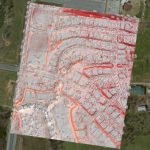
The GIS mapping services division of GEO Jobe has been quite active with UAV technology over the last year. We’ve turned to cutting edge hardware and software solutions to take to the sky and support some of our existing clients (and new ones) with imagery & analysis derived from UAV (drone) data acquisition.

Filed Under: LiDAR, Mobile, SPATIAL MEDIA AUTHORS, Top Features, UAV/UAS Tagged With: geo jobe, lidar, suas, UAV

Recent Industry News

The Drift Between Early Notes and Final Case Files in Abuse-Related Legal Support

April 29, 2026 By GISuser

Aerial Surveys Int’l and Global Marketing Insights to Present GEOINT 2026 Workshop on Multi-Domain Geospatial Fusion for Automated Infrastructure Monitoring

April 24, 2026 By GISuser

Why Timing Matters More Than You Think With Spray Seal (And Why People Often Get It Slightly Wrong)

April 22, 2026 By GISuser

The Quiet Planning Stage Most People Don’t See When Building a Pool in Brisbane

April 22, 2026 By GISuser

Hot News

State of Data Science Report – AI and Open Source at Work

HERE and AWS Collaborate on New HERE AI Mapping Solutions

Virtual Surveyor Adds Productivity Tools to Mid-Level Smart Drone Surveying Software Plan

Categories

Copyright gletham Communications 2015 - 2026

Go to mobile version