GEO Jobe UAV and Aerial Mapping Services (geo-jobe.com/uav) shares its insights
The rate of change in technology and software is a bit like a speeding train. It is difficult to know when to jump on and exactly where it is going. For most, it appears to be a matter of holding one’s breath and taking the leap. That is why it is nice to get the perspective of an early technology adopter who can speak from their experience.
GEO Jobe UAV and Aerial Mapping Services, based in Nashville, is like many professional service providers–they want to use and offer their governmental and private customers cutting-edge tools and highly accurate data results. Geo Jobe is a GIS and GPS technology professional service provider offering UAV data capture and aerial mapping services, data processing and UAV image hosting.
The firm has more than 17 years of experience in GIS consulting, digital mapping, custom application development, enterprise GIS system support and geospatial data acquisition. GEO Jobe has a fleet of four drones and has four FAA-licensed UAV remote pilots on staff that are experienced in UAV and mobile data collection techniques for orthophotography updating, corridor mapping, asset inventory, terrain modeling, and 3D building-design-models.
“We recently had the opportunity to test the new and GNSS receiver service, which is designed to provide highly accurate positioning data into a smartphone or tablet,” stated Neill Jobe (@neilljobe), CEO GEO Jobe . “We are long-time Trimble users, so this was an opportunity to test their latest technology.”
Trimble Catalyst requires three components:
- A location-enabled mobile app on an Android device
- A subscription to the Catalyst service
- A Trimble DA-1 antenna that plugs directly into an Android smartphone or tablet USB port

Trimble mobile manager software running on Motorola smartphone
Essentially what Trimble has done is taken their core GNSS technology that runs on a hardware chip and created a software service that can run in an app on a smartphone or tablet. The user must select a monthly subscription based on the level of accuracy they want.
There are four accuracy levels available, based on optimal conditions:
- 1-Meter
- Sub-meter (30 cm – 75 cm)
- Decimeter (10 cm)
- Precision (1 cm – 2 cm)
The small, disk-shaped DA1 digital antenna can be pole mounted to provide easier access to satellite signals and to attach the smartphone or tablet to the pole (See image below). The antenna provides GNSS data to the phone or tablet.
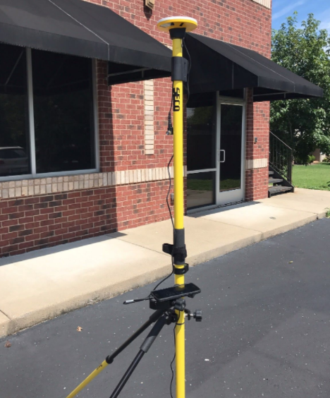
Seco pole with Trimble GNSS with Catalyst running on Android smartphone
“We used Trimble Catalyst for a project with Wilson County Water Utility in Middle Tennessee,” said Jeff Lawrence (@jalaw3), sUAS Business Development, GEO Jobe UAV Services. “The utility had hundreds of newly installed meters and valves that had not yet been added to the GIS mapping and asset management system.”
Wilson County, as with much of the other 40 counties that comprise the middle third of the state known as Middle Tennessee, has been experiencing tremendous growth. GEO Jobe hosts and helps maintain the base GIS data for Wilson County Water Utility. GEO Jobe partnered with the water utility staff by using Catalyst to capture these “missing” meters and valves.
The Esri® Collector for ArcGIS® mobile application was customized and connected to the utility ArcGIS Online asset web map service by the GEO Jobe field crew. They quickly discovered that Catalyst was reliable, easy to use, and was valuable to have on-site capturing the locations as the meters were being installed, rather than allowing a backlog to accumulate.
“Catalyst integrated directly and easily with Esri Collector,” stated Jeff. “As the field team navigated from location to location, Catalyst captured the new utility asset’s exact locations, while Collector created points and feature attributes in the GIS geodatabase in real time.”
To further evaluate Trimble Catalyst, GEO Jobe used a small 3- to 5-acre job that was completed for a surveyor client. The GCP points on the site were located to ensure optimal coverage for the UAV mission. The surveyor captured the actual coordinates for use in processing the aerial photography. GEO Jobe used Catalyst to capture the coordinates of the GPCs that were set as well. The Catalyst coordinates were then compared to those captured by the client’s survey grade equipment.
“The results from Catalyst were quite impressive,” Jeff said. “The Catalyst coordinates were within .25-inch to less than 1-inch of the results from the surveyor.”
See Tables below for the results of GEO Jobe’s analysis.


Catalyst is already integrated with several applications, including Trimble TerraFlex™ software, Trimble Penmap® for Android™ software, Trimble UAV Ground Control software, and other apps. Catalyst runs on Android OS and can also be used with any GPS-ready app found on the Google Play Store. Additionally, with an open SDK, Catalyst can be integrated directly into any application to deliver specialized GNSS positioning functionality and workflows.
Jeff went on to say “Overall, we were quite pleased with Trimble Catalyst performance. It delivered affordable, high-precision GNSS positioning on-demand directly to our smartphone or tablet. If I were writing a review for the popular online e-commerce retailer, I would definitely rate it five stars!”
To learn more about Trimble Catalyst, visit:
More about GEO Jobe UAV Services http://geo-jobe.com/uav or @geojobeuav (Instagram/Twitter)
Article /review by Jeff Lawrence, GEO Jobe UAV, Compiled by Jeff Winke, Associate Editor, Spatial Media (GISuser.com)