
Maxar Technologies collected new satellite imagery (October 22nd) of the East Troublesome Wildfire burning out of control near Rocky Mountain National Park (RMNP) in northern Colorado.
Satellite Imagery: Hurricane Sally Damage & Aftermath, Alabama

Yesterday (September 17), in between the clouds, Maxar Technologies’ WorldView-3 satellite collected new satellite imagery of the aftermath of Hurricane Sally that reveals damage to many homes, businesses and infrastructure along the Alabama Gulf coast.
Satellite Imagery: August Complex Fires, California

Maxar Technologies captured today (September 14) collected a set of satellite images of the August Complex wildfire, burning to the west of Chico, California and near the northern California coast.
Maxar Satellite Imagery: Phoenix and Talent Oregon Wildfires

Maxar Technologies collected new satellite imagery over the last two days of the intense wildfires burning across Oregon, focusing in on the aftermath of the Alameda Wildfire (also known as the Glendower Wildfire). On Tuesday morning (September 8, 2020), wildfires tore through the southern Oregon towns of Phoenix and Talent that destroyed hundreds of homes […]
Satellite Imagery via Maxar : Cameron Peak Wildfire, Colorado

Maxar Technologies collected new satellite imagery September 6th, of Colorado’s Cameron Peak wildfire that grew in size and intensity over the weekend and spread significant smoke across the Front Range cities of Colorado, including Fort Collins. Below is a gallery of satellite images from that include both Maxar’s high-resolution images from early Sunday afternoon, as […]
Satellite Imagery: LNU Lightning Wildfire in California via Maxar

Maxar’s WorldView-3 satellite collected new imagery yesterday afternoon (August 20th) of the LNU Lightning Complex wildfire burning in Sonoma County near Healdsburg, California.
Beirut Explosion: Maxar Technologies, Before-and-After Satellite Imagery
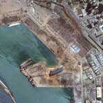
Several of Maxar’s satellites collected new imagery Aug 5, 2020 over Beirut that reveals the aftermath of the massive explosion in the port section of the city.
Portsmouth scientists help cyclone disaster response in coronavirus-hit Pacific

Researchers followed hot on the heels of a major cyclone that hit a Pacific island during the coronavirus pandemic, mapping the damage within hours.
SimActive Used to Determine Solar Potential from Satellite Imagery

Montreal, Canada, April 7th, 2020 – SimActive Inc., a world-leading developer of photogrammetry software, announces that his Correlator3D™ product is used by Dutch company NEO B.V. to assess solar potential in multiple cities. Digital surface models (DSMs) are generated from WorldView and GeoEye satellite stereo images and serve to calculate solar panel capacity.
Satellite Imagery – Locations around the World Affected by #coronavirus COVID-19

Maxar Technologies collected new satellite imagery from multiple locations around the world as the novel coronavirus, COVID-19, continues to spread.