GIS user technology news

News, Business, Technology, Mobile, GIS, Crypto Currency, AI, Economics

  • PRESS
    • Submit PR
    • Top Press
    • Business
    • Software
    • Hardware
    • UAV News
    • Mobile Technology
  • FEATURES
    • Around the Web
    • Social Media Features
    • EXPERTS & Guests
    • Tips
    • Infographics
  • Events
  • CAREERS
  • Advertising and Sponsored Posts
    • Advertising and Sponsored Posts
    • Submit Press
  • Shop
  • Tradepubs
  • Around the Web
  • Cool Links
You are here: Home / Archives for DigitalGlobe

DigitalGlobe Shares Satellite Imagery of California Superbloom

March 20, 2019 By GISuser

DigitalGlobe Satellite Imagery: California Superbloom

DigitalGlobe collected a new set of images yesterday (March 19th) of the “Superbloom” near Lake Elsinore, California. The colorful satellite imagery shows the hillsides along Walker Canyon filled with blooming poppies as well as hundreds of cars parked nearby and people hiking along trails in the area.

Filed Under: Earth Imaging - Remote Sensing, Top Text Lead Story Tagged With: California Superbloom, DigitalGlobe, Imagery, wildfire

DigitalGlobe Satellite Imagery: Flooding in U.S. Midwest

March 19, 2019 By GISuser

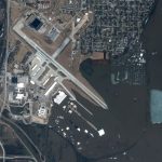
DigitalGlobe’s WorldView-2 satellite collected new imagery March 18, 2019 of the historic flooding of the Missouri and Platte rivers south of Omaha, Nebraska.

Filed Under: Earth Imaging - Remote Sensing, Emergency Response Tagged With: DigitalGlobe, flood

Satellite Imagery: Hurricane Michael Aftermath in Panama City and Tyndall AFB

October 12, 2018 By GISuser

Tyndall AFB

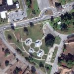
DigitalGlobe’s WorldView-1 satellite collected new imagery on October 11th of Panama City and Tyndall Air Force Base (AFB), Florida.

Filed Under: Earth Imaging - Remote Sensing, Emergency Response, Top Press Tagged With: DigitalGlobe, Hurricane Michael

DigitalGlobe Satellite Reveals Imagery of Russian Military Exercise (Vostok 2018)

September 14, 2018 By GISuser

Artillery and armored vehicles (Digitalglobe)

Two of DigitalGlobe’s high-resolution imaging satellites (GeoEye-1 and WorldView-3) collected new imagery this morning, September 13, 2018, of the large Russian military exercise (known as Vostok 2018)  being conducted at the Tsugol training area in eastern Russia.

Filed Under: Earth Imaging - Remote Sensing Tagged With: DigitalGlobe

Maxar Technologies’ DigitalGlobe Expands Agreements with Two Major Commercial Technology Customers

February 25, 2018 By Editor

Maxar Technologies’ DigitalGlobe Expands Agreements with Two Major Commercial Technology Customers, Extending Its Leadership Position in High-Resolution Satellite Imagery

Filed Under: Business, Earth Imaging - Remote Sensing Tagged With: DigitalGlobe

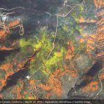
DigitalGlobe Releases High-Resolution Satellite Images of the Northern California Wildfires

October 12, 2017 By GISuser

Today DigitalGlobe released high-resolution satellite images of the wildfires burning in Northern California. These wildfires have killed at least 21 people, destroyed at least 3,500 structures, and burned more than 115,000 acres. In the above link, you’ll find imagery of the Santa Rosa, Calif., area taken yesterday and today.

Filed Under: Earth Imaging - Remote Sensing, Emergency Response Tagged With: DigitalGlobe

DigitalGlobe Releases High-Resolution Satellite Images of Mexico City

September 21, 2017 By Editor

Today DigitalGlobe released high-resolution satellite images that show the damage inflicted by the Sept. 19 earthquake in Mexico City.

Filed Under: Earth Imaging - Remote Sensing Tagged With: DigitalGlobe

Satellite Imagery: DigitalGlobe Releases High-Resolution Satellite Images of Hurricane Irma Damage

September 11, 2017 By GISuser

Port Barbuda - post Irma

As Hurricane Irma churned through the Caribbean and up Florida’s coast, DigitalGlobe’s satellites have been capturing high-resolution images of the storm’s damage. Imaging in the Caribbean became possible over the weekend as the clouds moved out of the area.

Filed Under: Earth Imaging - Remote Sensing, Emergency Response, Top Text Lead Story Tagged With: DigitalGlobe, hurricane irma

DigitalGlobe Announces Four-Year Direct Access Contract with the Australian Department of Defence

August 16, 2017 By GISuser

DigitalGlobe Announces Four-Year Direct Access Contract with the Australian Department of Defence for Real-time Access to the World’s Highest-Resolution Commercial Satellite Imagery

Filed Under: Earth Imaging - Remote Sensing Tagged With: DigitalGlobe

DigitalGlobe Announces Launch of SecureWatch

February 19, 2017 By Editor

DigitalGlobe Announces Launch of SecureWatch™, Advancing Mission Preparedness and Success When Decisions Matter Most

Filed Under: Business Tagged With: DigitalGlobe

Next Page »


featured podcast

Recent Features

Space Flight Laboratory (SFL) Announces Successful Launch & Deployment of HawkEye 360’s Cluster 11

FOSS4G NA 2024: The Premier Open Source Geospatial Conference Returns to St. Louis, September 9-11

Photographer Touch Reveal the Top Cameras, Lenses, and Photo Editing Tools of 2022

Digitalization and Simulation at the North Pole

Natural Gas District & GIS-Centric Asset Management

More Posts from this Category

Categories

Recent Posts

  • Scalable Data Protection: The Power Of Backup As A Service
  • The myth of earning $7,700 a day reappears: Dogecoin BSTR Miner cloud mining sets off a new storm of crypto wealth in 2025
  • Nvidia’s China Dilemma
  • How to Start Earning with Personal Loan Affiliate Programs (2025 Guide)
  • OhMyPretty Hair: Achieve a Dashing Look with Wear and Go Wigs & Colored Wigs

RSS Career Tips

  • Four Characteristics of the Best Virtual Employees
  • 28 Tools to Conquer the Social Media Recruiting World
  • 8 Questions Employers Should Ask About Coronavirus
  • Jobcase Launches Free Unemployment Resource Center for Workers Impacted by COVID-19
  • Must-Have Gadgets and Technology for the Remote Office Worker

RSS Tech pubs

  • How Developers Can Reduce High-Rise Construction Timelines Up To 30%
  • Breaking Barriers in B2B Healthcare Marketing: Expert Tips to Overcome This Year's Biggest Challenges
  • Experience the Industry's First Agentic AI Suite for API Security

RSS Computers

  • How the Cloud is Reshaping Virtual Desktops
  • Millennials as Brand Advocates - New Research Study Results
  • Vehicles Best Practices Installation Guide

RSS HR Tips

  • Future of Work: The APAC View
  • What Is an Agile Workspace?
  • Public Works & Utilities

RSS Gov Tech

  • Government Procurement: Technology: Solving Problems for Government
  • IWCE News Desk: Public Safety Communications
  • IWCE News Desk: Nemergent, Frequentis

RSS UAV news

  • DJI Matrice 4 Series Brings Intelligence to Aerial Operations
  • Virtual Surveyor Adds Productivity Tools to Mid-Level Smart Drone Surveying Software Plan
  • Nokia and Swisscom Broadcast to deploy largest Drones-as-a-Service network

RSS Geojobs

  • Senior Systems Administrator
Copyright gletham Communications 2011-2022

Go to mobile version