GIS user technology news

News, Business, AI, Technology, IOS, Android, Google, Mobile, GIS, Crypto Currency, Economics

  • Advertising & Sponsored Posts
    • Advertising & Sponsored Posts
    • Submit Press
  • PRESS
    • Submit PR
    • Top Press
    • Business
    • Software
    • Hardware
    • UAV News
    • Mobile Technology
  • FEATURES
    • Around the Web
    • Social Media Features
    • EXPERTS & Guests
    • Tips
    • Infographics
  • Blog
  • Events
  • Shop
  • Tradepubs
  • CAREERS
You are here: Home / Archives for * PRESS / LiDAR

SimActive Releases Version 8.6 of Correlator3D™

November 10, 2020 By Editor

SimActive Releases Version 8.6

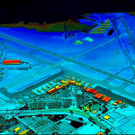
Montreal, Canada, November 9th, 2020 – SimActive Inc., a world-leading developer of photogrammetry software, announces the release of Correlator3D™ version 8.6. 

Filed Under: Business, LiDAR, Software, Top Text Lead Story Tagged With: SimActive

Global LiDAR Market to 2028

October 28, 2020 By Editor

Global LiDAR Market to 2028: Increasing Investments in Autonomous Vehicles is Expected to have a Positive Impact

Filed Under: LiDAR

Quantum Spatial Completes Data Collection for NOAA’s Largest Coastal Mapping Project

October 21, 2020 By Editor

Unique Combination of Sensors Used to Gather High Resolution Topographic and Bathymetric Lidar Data Along 12,000 Square Miles of Eastern Seaboard and Gulf Coast Areas Not Surveyed Since Civil War Era

Filed Under: Business, Earth Imaging - Remote Sensing, LiDAR Tagged With: NASA

VeriDaaS Plans Statewide California LiDAR Mapping Project in Spring 2021 for Public and Private Customers

October 21, 2020 By Editor

Colorized digital elevation model of International Airport in Pinellas County, Florida

Program Open to Cost-Sharing Partners

Filed Under: LiDAR Tagged With: lidar

Dewberry Receives ILMF and Lidar Magazine’s Outstanding Enterprise Achievement in Lidar Award

August 6, 2020 By GISuser

Dewberry Receives ILMF and Lidar Magazine's Outstanding Enterprise Achievement in Lidar Award

Firm named during 2020 GeoWeek virtual event

Filed Under: Business, LiDAR, Top Press Tagged With: Dewberry, ILMF, lidar

Teledyne Optech extends its innovative airborne lidar sensor series with new corridor mapping model

August 4, 2020 By GISuser

Teledyne Optech extends its innovative airborne lidar sensor series with new corridor mapping model

The new Galaxy CM2000’s small laser footprint allows for detection of fine corridor features

Filed Under: Business, Hardware, LiDAR Tagged With: lidar, Teledyne

Hexagon adds end-to-end 3D security surveillance capabilities with the acquisition of TACTICAWARE

August 3, 2020 By GISuser

Hexagon AB, a global leader in sensor, software and autonomous solutions, today announced the acquisition of TACTICAWARE, a provider of LiDAR-based 3D surveillance software used to monitor and protect critical infrastructure and buildings – from powerplants and airports to commercial and residential buildings and more.

Filed Under: acquisitions and funding, LiDAR Tagged With: heaxagon, lidar

Velodyne Lidar Sensors Power Emesent’s Hovermap to Fly Beyond the Visual Line of Sight

July 30, 2020 By GISuser

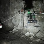
Emesent’s AL2 for Hovermap Leverages Velodyne Lidar to Access the Inaccessible

Filed Under: LiDAR

Winners Announced at the Third Annual Lidar Leader Awards Ceremony

July 25, 2020 By GISuser

Nominate a peer for the third annual Lidar Leader Awards

C. Wayne Wright, Karen Schuckman, GeoCue Group Inc., Blue Marble Geographics, and Dewberry

Filed Under: Business, Featured TOP PR, LiDAR Tagged With: lidar

GeoCue’s True View Awarded ILMF “Outstanding Innovation in LIDAR”

July 22, 2020 By GISuser

July 22, 2020 – Huntsville, AL – The International LIDAR Mapping Forum (ILMF) and Geo Week hosted their 3rd annual 2020 Lidar Leader Awards presentation where the board recognized GeoCue Group’s True View® 410 3D Imaging System (3DIS™) as the 2020 Outstanding Innovation in LIDAR winner. 

Filed Under: LiDAR Tagged With: GeoCue, lidar

« Previous Page
Next Page »

Recent Industry News

The Drift Between Early Notes and Final Case Files in Abuse-Related Legal Support

April 29, 2026 By GISuser

Aerial Surveys Int’l and Global Marketing Insights to Present GEOINT 2026 Workshop on Multi-Domain Geospatial Fusion for Automated Infrastructure Monitoring

April 24, 2026 By GISuser

Why Timing Matters More Than You Think With Spray Seal (And Why People Often Get It Slightly Wrong)

April 22, 2026 By GISuser

The Quiet Planning Stage Most People Don’t See When Building a Pool in Brisbane

April 22, 2026 By GISuser

Hot News

State of Data Science Report – AI and Open Source at Work

HERE and AWS Collaborate on New HERE AI Mapping Solutions

Virtual Surveyor Adds Productivity Tools to Mid-Level Smart Drone Surveying Software Plan

Categories

Copyright gletham Communications 2015 - 2026

Go to mobile version