Hallowell, ME — July 17, 2020 — Blue Marble Geographics® (bluemarblegeo.com) received the 2020 Outstanding Team Achievement in Lidar Award presented by the International Lidar Mapping Forum (ILMF) and Lidar Magazine at a virtual ceremony on July 16th.
Quanergy Unveils Next Generation 3D LiDAR Solution for Security, Smart Space and Smart City Markets
SUNNYVALE, Calif. – July 15, 2020 – Quanergy Systems, Inc., a leading provider of LiDAR (Light Detection and Ranging) sensors and smart perception solutions, today unveiled the MQ-8 solution family, a new generation of 3D LiDAR sensors and perception software which are part of Quanergy’s Flow Management™ platform.
Quanergy Secures First AI-Powered 3D LiDAR Integration with Industry Leading Security Center Platform From Genetec

SUNNYVALE, Calif.—Quanergy Systems, Inc., a leading provider of LiDAR (Light Detection and Ranging) sensors and smart perception solutions, today announced the first commercial integration of 3D AI-powered LiDAR solutions with the Genetec Inc. (“Genetec”) Security Center unified security platform. The integrated solutions will provide advanced people flow and occupancy management in smart spaces as well as enhanced […]
Florida Panhandle to be Mapped for Enhanced QL1 Lidar Data Following Hurricane Michael Damage
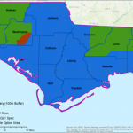
DEWBERRY TO PROVIDE ENHANCED QL1 LIDAR FOR FLORIDA PANHANDLE – Firm to provide data for U.S. Geological Survey following widespread impacts of Hurricane Michael
iXblue, Woolpert Partner to Deliver Lidar Mapping Services to New Zealand Councils
BRISBANE, Australia (June 17, 2020) — Woolpert and iXblue Sea Operations division, part of the French-based iXblue Group, have been awarded two significant airborne lidar mapping projects in New Zealand, covering over 38,500 square kilometres for the Hawke’s Bay and Waikato regional and local councils.
GeoCue Group Releases True View 615/620; RIEGL/Applanix-based UAS LIDAR System
June 17, 2020 HUNTSVILLE, AL – GeoCue Group announces the release of their new True View® 615 and True View 620 UAS LIDAR/Imagery 3D imaging systems (3DIS). GeoCue’s True View 615 & 620 are equipped with RIEGL’s miniVUX-2UAV laser scanner integrated with dual photogrammetric cameras.
CHC Navigation Introduces BB4 UAV and AlphaUni LiDAR Series
Multi-platform, high-accuracy 3D laser scanning solutions for geospatial and mapping professionals.
Quanergy becomes the first LiDAR Partner for Milexia Italia
Innovative LiDAR platform Now Available for Advanced Industrial Automation, Mapping, and Unmanned Vehicles
Finnish Space Data Company Terramonitor launches a Web Store

Terramonitor launches a Web Store that provides easy access to analysis-ready satellite images and up-to-date satellite maps. By processing thousands of satellite images per day with AI and cloud computing, Terramonitor provides revolutionary tools for monitoring and analyzing the globe from space.
Teledyne Optech partners with Aerial Surveys International to provide hyper-realistic mapping solution
Vaughan, CANADA, May 12, 2020 ─ Teledyne Optech, a Teledyne Technologies [NYSE:TDY] company and global leader in advanced lidar sensors, announced they have signed an agreement with Aerial Surveys International (ASI) to sell a Galaxy T2000, upgrade their existing Galaxy Prime to a Galaxy T2000 and install both sensors in the productivity-doubling G2 Sensor System.