
Vaughan, Ontario, CANADA – February 3, 2022 – Teledyne Geospatial announced the sale of its next generation bathymetric lidar CZMIL SuperNova to leading professional services firm Dewberry. Dewberry is the first private North American company to purchase the CZMIL SuperNova, adding this unique capability in support of state and federal coastal zone mapping programs, surveying of wetlands, lacustrine […]
Larry Sugarbaker Joins Dewberry’s Geospatial and Technology Services Group

GIS expert formerly served as USGS senior advisor to the National Geospatial Program
Dewberry Awarded Multiple USGS Earth MRI Task Order
Firm will provide geophysical surveying services across multiple states
Dewberry Receives ILMF and Lidar Magazine’s Outstanding Enterprise Achievement in Lidar Award

Firm named during 2020 GeoWeek virtual event
Dewberry Executive Phil Thiel Joins Esri Partner Advisory Council

Dewberry executive will advise on strategic direction of partner program
Florida Panhandle to be Mapped for Enhanced QL1 Lidar Data Following Hurricane Michael Damage
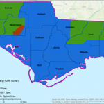
DEWBERRY TO PROVIDE ENHANCED QL1 LIDAR FOR FLORIDA PANHANDLE – Firm to provide data for U.S. Geological Survey following widespread impacts of Hurricane Michael
NOAA Shoreline Mapping Contract Awarded to Dewberry
Firm continues support under new five-year IDIQ
Dewberry Collecting Lidar Data of Western Everglades National Park for U.S. Geological Survey
Florida-based data collection encompasses 788 square miles
Dewberry Awarded USACE South Atlantic Coastal Study Architecture/Engineering Services Task Order
USACE Wilmington District awards firm Congressionally mandated study
Dewberry Selected to Provide Analytical Services for Prince William County Service Authority
Firm to deliver professional on-call services for PWCSA’s Cityworks asset management system implementation