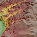
LEUVEN, Belgium, 8 July 2019 – Virtual Surveyor has enhanced the LiDAR elevation data handling capabilities in Version 6.4 of its drone surveying and mapping software. A new function enables Virtual Surveyor users to select specific feature classes from classified LiDAR point clouds before converting the point cloud to a surface terrain.
Virtual Surveyor Enhances LiDAR Point Cloud Handling in Latest Drone Mapping Software
LEUVEN, Belgium, 8 July 2019 – Virtual Surveyor has enhanced the LiDAR elevation data handling capabilities in Version 6.4 of its drone surveying and mapping software. A new function enables Virtual Surveyor users to select specific feature classes from classified LiDAR point clouds before converting the point cloud to a surface terrain.
GeoCue Introduces True View, The Industry’s First Drone LIDAR/Imagery Fusion Sensor
Nashville, TN – GeoCue Group Inc. unveiled its new True View™ line of drone sensors at an invitation only industry event on June 25th in Nashville, Tennessee.
LIDARUSA Puts Safety First With Drone Rescue Systems

LiDARUSA is pleased to announce the option of the Drone Rescue Systems parachute system with all DJI M600 UAV sales.
Velodyne Features Advanced Lidar for Port Terminal Automation at TOC Europe

Velodyne Integrator DGWorld Showcases Advanced Vehicle Automation
YellowScan Introduces CloudStation Software
YellowScan, the UAV LiDAR Solutions leader, announced today the release of its new software. CloudStation provides a complete solution to create and manipulate point-cloud data. It allows to extract, process and display data immediately after flight acquisition. The auto-generation of flight lines and the production of LAS files are now done in a few clicks.
Virtual Surveyor Unveils Terrain Lenses in Drone Mapping Software

Better Understanding of Topography
Missouri’s Geospatial Community Reacts with Emergency Tornado Mapping of Jefferson City, MO
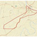
To initiate emergency response protocol in response to the Jefferson City tornado, the State and local geospatial community sprang into action as soon as the tornado hit.
YellowScan continues to expand in Asia with a new subsidiary in Japan YellowScan

May 21st 2019 – Tokyo, Japan – YellowScan, designer, developper and producer of UAV LiDAR solutions for professional applications, continues to expand its presence in Japan with the opening of a new office located at Shibuya, Tokyo.
ROAD-SCANNER and Rail-SIT for the Emilia Romagna Railways Inspection
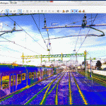
16 May, 2019, Bologna Italy – On behalf of the Emilia Romagna Railways (Ferrovie Emilia Romagna), Siteco started a verification project of the clearance outlines of the regional railways, in compliance with the European Standards, EN 15273-3: 2013.