MADISON, AL – GeoCue Group will present a True View Demonstration Day in Davis, California with the partnership of California Department of Forestry & Fire Protections and California Department of Transportation on October 3, 2019.
Teledyne Optech announces the CL-360, a compact, long-range, survey-grade lidar sensor for UAV and mobile applications
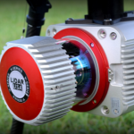
VAUGHAN, Canada — September 12, 2019 — Teledyne Optech, a Teledyne Technologies [NYSE:TDY] company and global leader in advanced lidar sensors, is pleased to announce the CL-360, the next offering in its new line of compact lidar sensors for UAV and mobile applications.
Teledyne Optech to preview new Compact Airborne and Mobile Lidar Solutions at INTERGEO 2019
Vaughan, ON, Canada — September 3, 2019 — Teledyne Optech, a Teledyne Technologies [NYSE:TDY] company, is poised to make an impact at InterGEO during its 45th Anniversary this year with new technologies in airborne, mobile and compact lidar solutions. Teledyne Optech invites guests to visit its exhibit in Hall 3, booth B3.042 to learn about new solutions designed to take survey and mapping operations to the next […]
geoDVR Mini Deployed on BVLOS Drone in China

Remote GeoSystems Deploys geoDVR Mini Video Recorder for BVLOS Drone Pipeline Patrol, Inspections and Security in China with Xi’an ARTEL
Dewberry Collecting Lidar Data of Western Everglades National Park for U.S. Geological Survey
Florida-based data collection encompasses 788 square miles
VeriDaaS Enters High-Density Geospatial Data and Products Market with Geiger-Mode LiDAR Technology

DENVER, CO, August 12, 2019 —VeriDaaS Corporation purchased Geiger-mode LiDAR technology from L3Harris Technologies to collect and process high-density 3D mapping data that will be resold on L3Harris’ IntelliEarth™ Marketplace.
Velodyne Lidar Acquires Mapper.ai for ADAS Launch

Velodyne adds Mapper’s mapping and localization software to advance revolutionary lidar-centric ADAS
Webinar / Video – The Modern Drone Mapping Project – Choosing the Right Approach

Didn’t catch the live webinar streamed from the ESRIUC? No problem, enjoy this video archive – The Modern Drone Mapping Project – Choosing the Right Approach, presented by Woolpert as part of the LiDAR Magazine webinar series.
Idriverplus Building Smart Autonomous Vehicles With Velodyne Lidar Technology

Velodyne Sensors Deliver Industry-Leading Range and Resolution to Idriverplus Autonomous Driving Products
LiDARUSA Announces Long Endurance Multicopter LiDAR Solution
LiDARUSA is pleased to announce the integration of their UAV-scanning systems with the Harris Aerial H4/H6 Hybrid multicopters.