GIS user technology news

News, Business, AI, Technology, IOS, Android, Google, Mobile, GIS, Crypto Currency, Economics

  • Advertising & Sponsored Posts
    • Advertising & Sponsored Posts
    • Submit Press
  • PRESS
    • Submit PR
    • Top Press
    • Business
    • Software
    • Hardware
    • UAV News
    • Mobile Technology
  • FEATURES
    • Around the Web
    • Social Media Features
    • EXPERTS & Guests
    • Tips
    • Infographics
  • Blog
  • Events
  • Shop
  • Tradepubs
  • CAREERS
You are here: Home / Archives for yellowscan

YellowScan Introduces CloudStation Software

June 8, 2019 By GISuser

YellowScan Introduces CloudStation Software

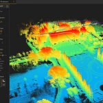
YellowScan, the UAV LiDAR Solutions leader, announced today the release of its new software. CloudStation provides a complete solution to create and manipulate point-cloud data. It allows to extract, process and display data immediately after flight acquisition. The auto-generation of flight lines and the production of LAS files are now done in a few clicks.

Filed Under: LiDAR, Software, Top Press, UAV/UAS Tagged With: lidar, yellowscan

YellowScan continues to expand in Asia with a new subsidiary in Japan YellowScan

May 28, 2019 By GISuser

YellowScan continues to expand in Asia with a new subsidiary in Japan YellowScan

May 21st 2019 – Tokyo, Japan – YellowScan, designer, developper and producer of UAV LiDAR solutions for professional applications, continues to expand its presence in Japan with the opening of a new office located at Shibuya, Tokyo.

Filed Under: Business, LiDAR, UAV/UAS Tagged With: yellowscan

Recent Industry News

The Drift Between Early Notes and Final Case Files in Abuse-Related Legal Support

April 29, 2026 By GISuser

Aerial Surveys Int’l and Global Marketing Insights to Present GEOINT 2026 Workshop on Multi-Domain Geospatial Fusion for Automated Infrastructure Monitoring

April 24, 2026 By GISuser

Why Timing Matters More Than You Think With Spray Seal (And Why People Often Get It Slightly Wrong)

April 22, 2026 By GISuser

The Quiet Planning Stage Most People Don’t See When Building a Pool in Brisbane

April 22, 2026 By GISuser

Hot News

State of Data Science Report – AI and Open Source at Work

HERE and AWS Collaborate on New HERE AI Mapping Solutions

Virtual Surveyor Adds Productivity Tools to Mid-Level Smart Drone Surveying Software Plan

Categories

Copyright gletham Communications 2015 - 2026

Go to mobile version