GIS user technology news

News, Business, AI, Technology, IOS, Android, Google, Mobile, GIS, Crypto Currency, Economics

  • Advertising & Sponsored Posts
    • Advertising & Sponsored Posts
    • Submit Press
  • PRESS
    • Submit PR
    • Top Press
    • Business
    • Software
    • Hardware
    • UAV News
    • Mobile Technology
  • FEATURES
    • Around the Web
    • Social Media Features
    • EXPERTS & Guests
    • Tips
    • Infographics
  • Around the Web
  • Events
  • Shop
  • Tradepubs
  • CAREERS
You are here: Home / Archives for * PRESS / Environment

New USGS map shows where the most damaging earthquakes are likely to occur in the US

February 4, 2024 By GISuser

USGS scientists and our partners recently revealed the latest National Seismic Hazard Model, showing that nearly 75% of the United States could experience a damaging earthquake, emphasizing seismic hazards span a significant part of the country.

Filed Under: DATA, Earth Imaging - Remote Sensing, Environment, Featured TOP PR Tagged With: are, damaging, Data, earth, earthquakes, environment, featured, imaging, likely, map, most, New, occur, remote, sensing, shows, the, top, USGS, Where

Marine Institute and TCarta Student Internship Program Makes Major Data Contribution to Seabed 2030 Project

November 8, 2023 By GISuser

Marine Institute and TCarta Student Internship Program Makes Major Data Contribution to Seabed 2030 Project

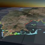
TCarta Marine, a global provider of hydrospatial products and services, has delivered three major satellite derived bathymetry (SDB) data sets to The Nippon Foundation-GEBCO Seabed 2030 project. Students in Canada participating in a 2023 summer internship program created the SDB products for the entire coastline of Madagascar, Newfoundland, and two Canadian Arctic research areas.

Filed Under: Business, Environment, Top Text Lead Story Tagged With: Marine, TCarta

NOAA forecasters increase Atlantic hurricane season prediction to ‘above normal’

August 18, 2023 By GISuser

Likelihood of greater activity rises due to record-warm sea surface temperatures

Filed Under: Environment Tagged With: NOAA

HP study finds climate crisis is changing parental decisions on purchasing, careers and even family size

June 26, 2023 By GISuser

PALO ALTO, Calif., June 20, 2023 (GLOBE NEWSWIRE) — Today, HP announced new global research conducted by Morning Consult revealing the serious actions many parents are taking due to climate change, from everyday decisions to long-term family planning.

Filed Under: Business, Environment Tagged With: HP

Ecobot Launches StoryMap Demonstrating Regional Effects of SCOTUS Ruling

June 20, 2023 By GISuser

Ecobot Launches StoryMap

ASHEVILLE, NC / ACCESSWIRE / June 15, 2023 / Ecobot, the platform driving the digitization of mandatory pre-construction environmental assessments, today launched an interactive ArcGIS StoryMap to help environmental consultants and citizens understand how the recent Sackett v. EPA ruling by the Supreme Court of the United States (SCOTUS) will play out across the country based on existing local, state, […]

Filed Under: Business, DATA, Environment, Featured TOP PR Tagged With: Ecobot, storymap

Spire Global and OroraTech Awarded Contract by Canadian Space Agency to Demonstrate Wildfire Detection Methods from Space

May 9, 2023 By GISuser

Vienna, VA, May 9, 2023 – The Canadian Space Agency (CSA) has awarded a contract to Spire Global, Inc. (NYSE: SPIR) (“Spire” or “the Company”) subsidiary ExactEarth Ltd. to deliver preparatory work for implementation phases of a wildfire monitoring satellite.

Filed Under: Business, Environment

Jack and Laura Dangermond Honored with Conservation Visionary Award

April 27, 2023 By GISuser

Esri Founders Recognized by International Land Conservation Network for Environmental Efforts

Filed Under: Environment Tagged With: environment, ESRI

Biden-Harris Administration Announces New Steps for Climate Resilience and Forest Conservation

April 22, 2023 By GISuser

At President Biden’s Direction, USDA and Interior Release Inventory of Mature and Old-Growth Forests, Set Reforestation Targets for Federal Lands

Filed Under: Business, Environment, Top Text Lead Story Tagged With: forests, USDA

New big game migration maps support conservation planning across the West

January 2, 2023 By GISuser

LARAMIE, Wyo.—The USGS, in partnership with state and Tribal wildlife agencies, today published the third volume in a series of new maps of big game migration corridors. The new maps add more valuable tools for land managers and policy makers to mitigate the impacts of development on wildlife.

Filed Under: Environment Tagged With: conservation, USGS, wildlife

University of Hawaii, NOAA to gather climate change data following Mauna Loa eruption

December 30, 2022 By GISuser

NOAA will partner with the University of Hawaii (UH) to collect atmospheric measurements at the Maunakea Observatoriesoffsite link on the Big Island of Hawaii. These measurements will provide records of global carbon dioxide (CO2) similar to those gathered for more than six decades at NOAA’s Mauna Loa Observatory (MLO), and will provide key information to track global climate change.

Filed Under: Environment Tagged With: NOAA

Next Page »

Recent Posts

  • Ultimate Guide to UGG Boots Women: Style, Comfort, and Care Tips
  • ChatGPT and Claude Built My Company’s 500+ Prompt Library — Team Productivity 10X
  • How to Become a Certified ADHD Assessor: Training and Requirements
  • What’s the Difference Between NID Prelims and Mains? Creativedge Breaks It Down
  • Coffee and Diabetes: What the Research Really Says
  • Sota Video AI: Where Real-World Motion Meets Cinematic Mastery
  • What Is an Interest Rate Increase? 
  • Playzee Casino Canada — clear, candid, and built for players
  • PartyCasino Canada: a straight-up take for players who like things clear
  • Kitchen Remodels and Additions: The Ultimate Upgrade for Modern Living

Recent Features

Space Flight Laboratory (SFL) Announces Successful Launch & Deployment of HawkEye 360’s Cluster 11

FOSS4G NA 2024: The Premier Open Source Geospatial Conference Returns to St. Louis, September 9-11

Photographer Touch Reveal the Top Cameras, Lenses, and Photo Editing Tools of 2022

Digitalization and Simulation at the North Pole

Natural Gas District & GIS-Centric Asset Management

More Posts from this Category

Categories

RSS Career Tips

  • Four Characteristics of the Best Virtual Employees
  • 28 Tools to Conquer the Social Media Recruiting World
  • 8 Questions Employers Should Ask About Coronavirus
  • Jobcase Launches Free Unemployment Resource Center for Workers Impacted by COVID-19
  • Must-Have Gadgets and Technology for the Remote Office Worker


featured podcast

RSS Tech pubs

  • The Ultimate Guide to Paying Out Tips
  • The Smart Pay Playbook
  • The Complete Guide to Cloud ERP Solutions

RSS Computers

  • How the Cloud is Reshaping Virtual Desktops
  • Millennials as Brand Advocates - New Research Study Results
  • Vehicles Best Practices Installation Guide

RSS HR Tips

  • AWS GovCloud (US) Celebrates 10th Anniversary and a Decade of Digital Transformation in the Federal Government
  • Exploring the Impact of COVID-19 on Customer Behavior
  • The Pivot to 100% Remote Training in the Contact Center

RSS Gov Tech

  • 10 Legal Jobs You Can Get Without a Law Degree
  • J.D. Power Examines How the Inflation Reduction Act Reshapes EV Landscape
  • Making Telehealth Work for You: The Ultimate Guide

Copyright Spatial Media LLC 2003 - 2015

Go to mobile version