Faster, More Productive Image Capture
Imagery, earth imaging and remote sensing
NASA’s Mars Helicopter to Make First Flight Attempt Sunday

NASA’s Ingenuity Mars Helicopter is two days away from making humanity’s first attempt at powered, controlled flight of an aircraft on another planet.
Satellite Imagery @Maxar : Piney Point Phosphate Wastewater Ponds, Florida

Maxar collected new satellite imagery today, April 5th, that reveals the leak in the retaining wall of a wastewater holding pond in Piney Point, Florida near Tampa Bay. The leak at the reservoir, first discovered last month, is situated next to an abandoned phosphate plant. Emergency crews are removing millions of gallons of water from […]
Satellite Imagery via @Maxar : Russian Nuclear Submarines Through Arctic Ice
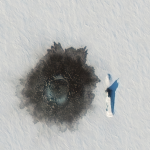
Maxar collected new satellite imagery on March 27th that reveals the Russian naval exercise (known as Umka-2021) in progress in the Arctic.
March 28 Update – @Maxar WorldView-3 satellite shows close up of excavation around EVER GIVEN ship and dredging ops

March 28th Satellite Imagery Update on Suez Canal and EVER GIVEN Ship
Today’s High Resolution Satellite Imagery of Suez Canal and EVER GIVEN Container Ship @Maxar
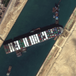
Maxar’s WorldView-3 satellite collected high-resolution imagery this morning (March 27, 2021) of the Suez Canal and efforts in progress to free the grounded EVER GIVEN container ship.
Satellite Imagery of Suez Canal and Stuck Container Ship @Maxar
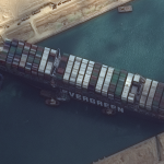
Maxar’s WorldView-2 collected new high-resolution satellite imagery this morning (March 26th) of the Suez canal and the container ship (EVER GIVEN)–a 1,300-foot ship operated by the Taiwan-based Evergreen Group–that remains stuck in the canal north of the city of Suez, Egypt. In today’s satellite imagery, multiple tug boats are positioned alongside the ship and dredging operations […]
Dubai Municipality Announces Launch of DMSat-1 Atmospheric Monitoring Microsatellite Built by Space Flight Laboratory (SFL)

TORONTO, Ontario, Canada, 22 March 2021 – Dubai Municipality announced the successful launch and deployment of DMSat-1, an atmospheric monitoring microsatellite built by Space Flight Laboratory (SFL). DMSat-1 launched today from the Baikonur Cosmodrome in Kazakhstan aboard a Soyuz rocket.
OneAtlas taps into expanded markets to provide easy access to imagery and insights

Toulouse, 11 March 2021 – Up and running for two years, OneAtlas has become a key digital asset for a large number of Airbus geospatial customers, who use the platform daily to access a very wide range of imagery products and AI- based analytics. It enables them to easily monitor economic activities and supports their decision-making.
TCarta Awarded NOAA Grant to Enhance Satellite Derived Bathymetry Technology in Alaskan Waters

Focus on Accuracy