GIS user technology news

News, Business, AI, Technology, IOS, Android, Google, Mobile, GIS, Crypto Currency, Economics

  • Advertising & Sponsored Posts
    • Advertising & Sponsored Posts
    • Submit Press
  • PRESS
    • Submit PR
    • Top Press
    • Business
    • Software
    • Hardware
    • UAV News
    • Mobile Technology
  • FEATURES
    • Around the Web
    • Social Media Features
    • EXPERTS & Guests
    • Tips
    • Infographics
  • Blog
  • Events
  • Shop
  • Tradepubs
  • CAREERS
You are here: Home / * PRESS / Earth Imaging - Remote Sensing / Today’s High Resolution Satellite Imagery of Suez Canal and EVER GIVEN Container Ship @Maxar

Today’s High Resolution Satellite Imagery of Suez Canal and EVER GIVEN Container Ship @Maxar

March 27, 2021 By Editor

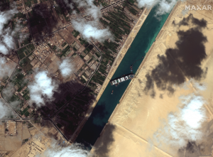
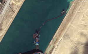
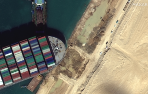
Maxar’s WorldView-3 satellite collected high-resolution imagery this morning (March 27, 2021) of the Suez Canal and efforts in progress to free the grounded EVER GIVEN container ship.

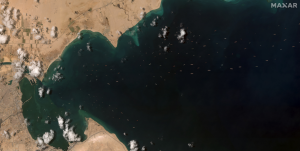
This new imagery provides a very detailed look at the dredging operations which continue near the ship as well as earth moving equipment excavating sand near the bow of the ship. Additionally, Maxar’s WorldView-2 satellite collected a large area (nearly 2,500 square kilometers in one image) along the canal and the Gulf of Suez this morning. The imagery reveals that more than 120 ships are anchored south of the entrance to the canal and remain unable to transit due to the grounded ship in the canal. In the link provided below, you can download a gallery of today’s imagery that include the very close up views of the EVER GIVEN ship, the ongoing efforts to free the ship as well as the overview of the ships waiting south of the canal.


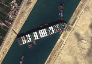
Satellite image ©2021 Maxar Technologies

Filed Under: Earth Imaging - Remote Sensing, Top Text Lead Story

Editor’s Picks

Event Review, Commercial Drone Expo

HUD and Zillow Hacking for Affordable housing

Boulder County Launches New Geospatial Open Data Platform

Geospago and what3words partner to provide a mobile mapping solution with 3-word addressing throughout the globe

See More Editor's Picks...

About Editor

Glenn is a geographer and a GIS professional with over 20 years experience in the industry. He's the co-founder of GISuser and several other technology web publications.

Recent Industry News

Why Bathroom Renovation Services Often Change More Than Just the Bathroom

May 20, 2026 By GISuser

The Drift Between Early Notes and Final Case Files in Abuse-Related Legal Support

April 29, 2026 By GISuser

Aerial Surveys Int’l and Global Marketing Insights to Present GEOINT 2026 Workshop on Multi-Domain Geospatial Fusion for Automated Infrastructure Monitoring

April 24, 2026 By GISuser

Why Timing Matters More Than You Think With Spray Seal (And Why People Often Get It Slightly Wrong)

April 22, 2026 By GISuser

Hot News

State of Data Science Report – AI and Open Source at Work

HERE and AWS Collaborate on New HERE AI Mapping Solutions

Virtual Surveyor Adds Productivity Tools to Mid-Level Smart Drone Surveying Software Plan

Categories

Copyright gletham Communications 2015 - 2026

Go to mobile version