
MARKHAM, Ontario, Canada and Cape Town, South Africa, 10 May 2021 – CATALYST, a PCI Geomatics brand, has delivered an automated workflow for the South African National Space Agency’s (SANSA) Earth Observation Department to convert decades of SPOT satellite imagery to CARD4L Analysis Ready Data (ARD). The scalable workflow enables SANSA to prepare its entire SPOT […]
Imagery, earth imaging and remote sensing
BlackSky Demonstrates Growth and Scalability with Planned Launch of Additional Satellites
Company Continues Constellation Expansion to Increase Capacity for First-to-Know Insights
Maxar Satellite Imagery: Train Derailment in Mexico City
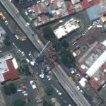
Maxar collected new satellite imagery (May 4, 2021) of the aftermath of the passenger train derailment that occurred on Monday night in southeastern Mexico City. According to media reports, a passenger train traveling along an elevated track derailed after a concrete overpass collapsed. At least 23 people were killed and 80 others were injured. In […]
TCarta Delivers Satellite-Derived Bathymetry to NOAA for U.S. Coastal Mapping Pilot
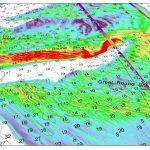
Validated with ICESat-2 Laser Data
National Imagery Summit SAVE THE DATE August 31, 2021 – September 2, 2021

August 31, 2021 – September 2, 2021 – 12:00pm – 5:00pm EST Daily
Norwegian Space Agency Announces Launch of NorSat-3 Maritime Tracking Microsatellite Built by Space Flight Laboratory (SFL)

TORONTO, Ontario, Canada, 29 April 2021 – The Norwegian Space Agency has announced the successful launch of the NorSat-3 maritime tracking microsatellite built by Space Flight Laboratory (SFL) in Toronto. NorSat-3 launched on April 28, 2021, aboard Vega Flight VV 18 from the Guiana Space Center in French Guiana.
Hexagon’s HxGN Content Program delivers state-wide six-inch resolution aerial imagery to Texas

Texas leverages new Content+ licensing model from the HxGN Content Program to obtain updated single-season imagery with higher refresh rates for select cities
Maxar Satellite Imagery of Crew Dragon 2 and Falcon 9 at Cape Canaveral

Maxar’s WorldView-3 satellite collected new imagery this morning (April 22nd at 11:13 AM, Eastern) of the Kennedy Space Center ahead of tomorrow morning’s SpaceX Falcon 9 launch with the Crew Dragon capsule that will carry four astronauts into orbit and a journey to the International Space Station (ISS).
Satellite Imagery @Maxar : Windsor Castle and St George Chapel, April 17th

Maxar collected new satellite imagery early this afternoon of Windsor Castle and St George Chapel, several hours before the funeral of Prince Philip, Duke of Edinburgh. The imagery was collected at 12:01 PM local time. A small crowd of people can be seen gathered along Thames Street near the grounds of the Castle.
Satellite Imagery via @Maxar : St. Vincent and Ongoing Volcanic Eruptions

Maxar collected new satellite imagery today of the Caribbean island of St. Vincent and the ongoing eruption of the La Soufriere volcano. In spite of heavy cloud cover (including ash clouds) in the area, today’s satellite view provides the first high-resolution look at the northwest coast of St Vincent and the large amount of ash […]