GIS user technology news

News, Business, AI, Technology, IOS, Android, Google, Mobile, GIS, Crypto Currency, Economics

  • Advertising & Sponsored Posts
    • Advertising & Sponsored Posts
    • Submit Press
  • PRESS
    • Submit PR
    • Top Press
    • Business
    • Software
    • Hardware
    • UAV News
    • Mobile Technology
  • FEATURES
    • Around the Web
    • Social Media Features
    • EXPERTS & Guests
    • Tips
    • Infographics
  • Blog
  • Events
  • Shop
  • Tradepubs
  • CAREERS
You are here: Home / Archives for **Front Page / Top Text Lead Story

London Borough of Harrow creates digital twin with new street imagery and LiDAR data

August 25, 2021 By GISuser

New approach will help improve Planning, Highways and Council Tax operations

Filed Under: Business, Earth Imaging - Remote Sensing, LiDAR, Top Text Lead Story Tagged With: lidar

Maxar Satellite Imagery: Kabul Airport, Afghanistan

August 16, 2021 By GISuser

Maxar Satellite Imagery: Kabul Airport, Afghanistan Inbox

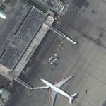
Maxar collected new high-resolution satellite imagery this morning (10:36 AM local time, 16 August) of the chaotic scene underway at Kabul’s Hamid Karzai International Airport in Afghanistan as thousands of people converged on the tarmac and airport runways as countries attempt to evacuate personnel from the city.

Filed Under: Earth Imaging - Remote Sensing, Emergency Response, Top Text Lead Story Tagged With: Afghanistan, maxar

Climate change widespread, rapid, and intensifying – IPCC

August 10, 2021 By GISuser

GENEVA, Aug 9 – Scientists are observing changes in the Earth’s climate in every region and across the whole climate system, according to the latest Intergovernmental Panel on Climate Change (IPCC) Report, released today.

Filed Under: Business, Environment, Top Text Lead Story Tagged With: environment, research, UN

Parrot, Verizon, and Skyward bring first 4G LTE connected drone to the US market

August 4, 2021 By GISuser

Parrot, Verizon, and Skyward bring first 4G LTE connected drone to the US market

New York, United States – Paris, France – August 4th, 2021:  Today, Verizon, Parrot, and Skyward announced an exclusive partnership to bring the first out-of-the-box 4G LTE connected drone solution to the United States.

Filed Under: Business, Top Text Lead Story, UAV/UAS Tagged With: drone, Parrot, UAV

INRIX Launches Location Analytics to Help Streamline Site Selection and Understand Buyer Behavior

July 28, 2021 By GISuser

New SaaS application surfaces location-based insights to maximize business growth and return on investment

Filed Under: Business, Top Text Lead Story Tagged With: INRIX

AccuWeather Launches Digital Hurricane Tracker In App and Online to Coincide with Above-Normal 2021 Hurricane Season

July 23, 2021 By GISuser

Innovative hurricane tracking feature brings most comprehensive hurricane information available to increase awareness of incoming hurricanes and their impacts, displaying exclusive AccuWeather Forecast Eye Path maps, impact graphics and easily navigable tools to track and follow storms for optimal preparation protection and insight.

Filed Under: Environment, Mobile, Software, Top Text Lead Story Tagged With: hurricane

Esri Releases New Predictive 2050 Global Land Cover Map

July 14, 2021 By Editor

Clark Labs Joins Esri to Deliver Map to Worldwide Users Showing 30 Year Projected Change

Filed Under: DATA, Environment, Top Text Lead Story Tagged With: arcgis, Data, ESRI, Living Atlas

Esri User Conference to Showcase How Organizations Use GIS to Create a More Sustainable Future

July 6, 2021 By Editor

Guest Speakers Will Discuss How Geospatial Technology Empowers Users to Shape Science, Policies, and Action

Filed Under: Business, Events, Top Text Lead Story Tagged With: arcgis, ESRI, esriuc, events

Trimble X7 and Perspective 3D Scanning Solution Garners Three International Design Awards 

July 5, 2021 By Editor

Solution’s Complete and Simplified Design by Global Team is Lauded by Judges 

Filed Under: Business, Hardware, Top Text Lead Story Tagged With: 3D, scanning, Trimble

Esri Releases New 2020 Global Land Cover Map 

June 24, 2021 By Editor

Esri Releases New 2020 Global Land Cover Map 

Project Joins Startup Impact Observatory and Microsoft to Deliver Map to Worldwide Users

Filed Under: Business, DATA, Environment, Maps and Cartography, Top Text Lead Story Tagged With: ESRI, land cover, Living Atlas, rcgis

« Previous Page
Next Page »

Recent Industry News

Why Adults Are Trimming Their Routines for Travel and Busy Weeks

June 10, 2026 By GISuser

Top Benefits of AI Video Surveillance for Businesses and Public Spaces

June 5, 2026 By GISuser

How to Choose the Best Office Interior Designers in Delhi for End-to-End Projects

June 3, 2026 By GISuser

Why Bathroom Renovation Services Often Change More Than Just the Bathroom

May 20, 2026 By GISuser

Hot News

State of Data Science Report – AI and Open Source at Work

HERE and AWS Collaborate on New HERE AI Mapping Solutions

Virtual Surveyor Adds Productivity Tools to Mid-Level Smart Drone Surveying Software Plan

Categories

Copyright gletham Communications 2015 - 2026

Go to mobile version