
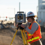
Focus on Accuracy
Trimble Announces Rugged, Lightweight Field Data Controller for Land and Construction Surveying

Trimble TSC5 Controller with 5-inch Screen, Keypad and Android Operating System Enables All-Day Field Data Collection in Harsh Environments
CATALYST Announces Cost-Effective, Fully Scalable Processing of Earth Observation Imagery on the Cloud
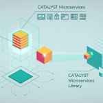
Process Petabytes in Minutes
Esri Federal GIS Conference Showcases How GIS Interconnects National Government

Annual Event Spotlights How Technology Empowers Staff and Collaboration Across Agencies
New Trimble SX12 Scanning Total Station Adds Features and Applications for Versatile Everyday Surveying and Scanning
Enhancements Open Up New Applications in Tunneling and Underground Mining
3D laser scan reveals Christ the Redeemer as you’ve never seen it before

Geospatial mapping specialist GeoSLAM has produced a never-before-seen digital twin of the inside of the world-famous Christ the Redeemer statue before its 90th birthday restoration work begins.
USGIF Accredits New University GEOINT Programs

The University of North Georgia added to the Foundation’s growing Collegiate Accreditation Program.
Esri Launches ArcGIS Platform

Comprehensive Location Services, Data, and Mapping Tools Are Available to Developers
Space Flight Laboratory (SFL) Announces Successful Launch of 12 Satellites on SpaceX Ride-Sharing Mission @SFL_SmallerSats
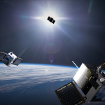
TORONTO, Ontario, Canada, 25 January 2021 – Space Flight Laboratory (SFL), a developer of complete microspace missions, today announced the launch and successful deployment of 12 satellites on January 24, 2021. The SpaceX Falcon 9 ride-sharing mission carried three different SFL-designed microspace platforms into orbit for three separate commercial constellations.
Webinar – Processing Large Drone Projects Webinar

The rapid processing of large drone projects (e.g. tens of thousands of images) presents significant challenges to the drone mapping industry.