GISuser.com

GIS and Technology news for mapping professionals

  • PRESS
    • Submit PR
    • Top Press
    • Business
    • GIS, Geo Tech Software
    • Hardware
    • UAV News
    • Mobile Technology
    • Editor’s Top Picks
    • Get TOP Listing!
  • FEATURES
    • GeoGeeksinCars
    • 10 Question Q&A
    • FROM THE EDITOR
    • SPATIAL MEDIA AUTHORS
    • Social Media Features
    • EXPERTS & Guests
    • Listicles and Top 10 Lists
    • Infographics
    • VIDEOS
  • Events
    • Webinars
    • Submit event
    • Event Media Partner
  • CAREERS
    • Career Help Articles
    • People and Career News
    • Work from Home
    • About GeoJobs.BIZ
  • About
    • Advertise
      • Advertise wth GISuser
      • Media Kit Request Form
      • Directory
      • Submit Press
    • Contact GISuser
    • Meet the Editor
    • Social Media
      • AnyGeo Blog
      • GeoGeeks Podcast
      • Social Media Features
      • Like Us
    • SpatialMedia
      • LBSzone
      • LiDAR Magazine
      • Amerisurv
      • SymbianOne
    • RSS feed
  • Blog
  • Shop
  • Cloud Hosting
    • Amazon Cloud Hosting
    • WordPress cloud hosting
    • Dedicated servers USA
    • Linux Shared Hosting
    • Windows Shared Hosting
    • Web Development
    • SSL Certificate
  • Tradepubs
You are here: Home / * PRESS / Business / 3D laser scan reveals Christ the Redeemer as you’ve never seen it before

3D laser scan reveals Christ the Redeemer as you’ve never seen it before

February 13, 2021 By Editor

Geospatial mapping specialist GeoSLAM has produced a never-before-seen digital twin of the inside of the world-famous Christ the Redeemer statue before its 90th birthday restoration work begins.

 3D laser scan reveals Christ the Redeemer

In 2019, it was visited over 2 million times with people from all over the globe traveling to admire the statue which soars 2,320 feet above the city of Rio de Janeiro.

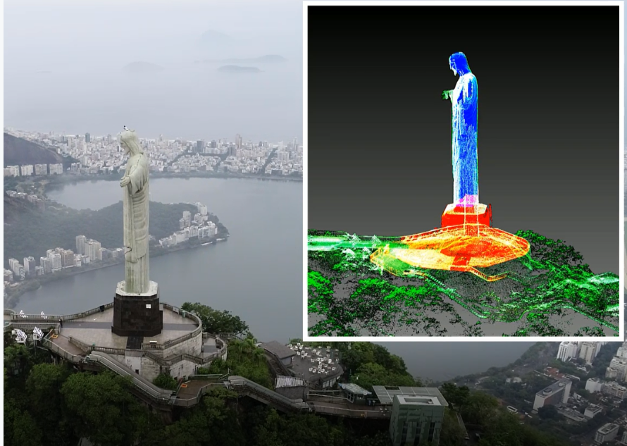
 Now, for the very first time, the historic statue built-in 1931, can be viewed from the inside and out, using the latest SLAM (simultaneous localisation and mapping) and UAV technology.

 To complete the scan, the summit of Mount Corcovado was closed to the public, allowing GeoSLAM’s Latin America Channel Manager, Gabriel de Barros Praxedes, and a small team from CPE Tecnologia, GeoSLAM’s Brazilian dealer, to scan the entire site – inside and out – within 45 minutes using the ZEB Horizon.

 Emblematic of the city of Rio de Janeiro and the nation of Brazil, the concrete-clad statue stands 98 feet tall and spans a mammoth 92 feet wide.

 The narrow staircases and tight internal passages were captured by the versatile ZEB Horizon, which emits 300,000 laser points per second as Gabriel climbed the stairs. The same ZEB Horizon was then mounted to a UAV to capture the full, detailed exterior of the monument.

 A series of 3D scans containing over 180 million points was captured, producing a comprehensive digital model of the giant monument in all its glory inside and out.

 The data was then quickly processed through GeoSLAM Hub, so Gabriel could see the results of the scan before he left the site, including the network of internal staircases.

3D laser scan reveals Christ the Redeemer

 Commenting on the never-before-seen feat, Gabriel, said: “Given the level of detail on this monument – from the face, hands and robe, to the staircases inside and carved marble base beneath it, I’m in awe of the capabilities of this technology and the clarity of data produced. We’ve been able to capture the statue in a totally new light, that almost no-one has had the privilege to see.

 He added: “This is one of the most recognisable statues on the planet, and a symbol of hope for many Brazilians near and far, and I’m delighted to have been able to capture it in its current form before the restoration works gets underway. It’s hard to believe this statue is almost 90 years old; the scan really highlights the level of detail.”

 GeoSLAM’s solutions are being used more and more to aid in the documentation and management of historic or hard-to-reach landmarks.

 For more information on GeoSLAM, visit www.geoslam.com.

Related Articles on GISuser:

  • Webinar / Video – The Modern Drone Mapping Project – Choosing the Right ApproachWebinar / Video – The Modern Drone Mapping Project – Choosing the Right Approach
  • AutonomouStuff and Real Earth are now working together to provide innovative SLAM productsAutonomouStuff and Real Earth are now working together to provide innovative SLAM products
  • LiDAR Feature – Random Points: Drones and LiDARLiDAR Feature – Random Points: Drones and LiDAR
  • Update on USGS 3D Elevation Program (3DEP) initiativeUpdate on USGS 3D Elevation Program (3DEP) initiative
  • Velodyne Showcases Advanced Lidar Solutions at Auto Shanghai 2021Velodyne Showcases Advanced Lidar Solutions at Auto Shanghai 2021
  • Lidar point cloud data along the Buffalo Bayou in Lynchburg, Texas, acquired in 2018 under Fugro’s previous StratMap contract for the Texas Department of Information ResourcesFugro wins repeat Geo-data solutions contract with State of Texas

Filed Under: Business, DATA, LiDAR, Top Text Lead Story Tagged With: 3D, Laser-Scan, lidar


Editor’s Picks

Location, Location, Location: Uses for GIS in Health Care

Location, Location, Location: Uses for GIS in Health Care

Opportunity – Promote your Company’s ESRIUC Week Activities with GISuser

Social Media is an Increasingly Important Part of Webmaps, Data Analysis, Analytics and Visualizations

Real Earth™ Wins Microsoft Competition for 3D Mapping and Localization

See More Editor's Picks...

About Editor

Glenn is a geographer and a GIS professional with over 20 years experience in the industry. He's the co-founder of GISuser and several other technology web publications.

Connect with GISuser

  • Facebook
  • Google+
  • LinkedIn
  • RSS
  • Twitter


GIS jobs

Recent Features

Digitalization and Simulation at the North Pole

Natural Gas District & GIS-Centric Asset Management

5 Ways Technology Is Affecting The Sharing Economy

Spotlight – Township Canada: Explore Canadian Legal Land Descriptions on a Map

GeoGeeksinCars – The one in “Tippy” the right-hand drive Mitsubishi, at DevSummit

More Posts from this Category

Categories


geoignite 2021

Recent Posts

  • Can My iPhone Get Hacked?
  • Satellite Imagery @Maxar : Windsor Castle and St George Chapel, April 17th
  • World Gas Map, 2021 Edition – Major Gasfields, Major Gas Pipelines, LNG Import Terminals and Export Plants, GTL Projects
  • Velodyne Showcases Advanced Lidar Solutions at Auto Shanghai 2021
  • Webinar: How Matrox IP KVM Solves the Challenges of Your Distributed Workforce

RSS Career Tips

  • Four Characteristics of the Best Virtual Employees
  • Jobcase Launches Free Unemployment Resource Center for Workers Impacted by COVID-19
  • 8 Questions Employers Should Ask About Coronavirus
  • Must-Have Gadgets and Technology for the Remote Office Worker
  • Must-Have Gadgets and Technology for the Remote Office Worker


shop for geogeek swag

RSS Tech pubs

  • Safety Alert for Supervisors Newsletter
  • Utilizing a Digital Platform to Drive Operational Improvements
  • The Essentials of Engineering - 2021 Edition

RSS Computers

  • The Essentials of Information Security Kit: Includes a Free PC Security Handbook - 2nd Edition eBook
  • iPad CTO Kit - including the iPad Tips and Tricks Guide for IT Executives and Managers
  • Windows... On Speed

RSS HR Tips

  • Applicant Tracking FrontRunners Report
  • Human Resources FrontRunners Report
  • How Diversity, Equity & Inclusion can Take Credit Unions into the Future

RSS Gov Tech

  • Am Law 100: Trends, Insights & How Firms Plan to Move Past the Pandemic
  • Hidden Risks to Patient Data Security
  • Appian for Federal Agencies

RSS UAV news

  • Parrot and High Lander enhance drone fleet automation
  • NASA’s Mars Helicopter to Make First Flight Attempt Sunday
  • Rhode Island Signs Participating Addendum with DroneUp

RSS Geojobs

  • Help Desk Technician
Copyright Spatial Media LLC 2003 - 2015