These days, the cloud has become one of the most sought-after software deployment models across the globe. However, it doesn’t mean SAP, ERP and Cloud are free from myths. In fact, it seems that the more popular a model, the higher the number of myths surrounding it. Here are some top myths surrounding SAP, ERP, […]
3 Geospatial Industry Thought Leaders Share a Look at 2017 & Geo Industry Outlook, Trends to Watch in 2018

Year end is rapidly approaching and that leaves us with the usual questions: what was hot in 2017 and what’s on the horizon for the GeoTech industry in 2018? I reached out to several GeoTech industry leaders for their opinion and they enthusiastically shared their thoughts, experience, and vision. Thanks to James Fee, Anthony Quartararo, and […]
ArcGIS Pro the next step in the evolution of ArcGIS Technology from Esri

We recently heard the latest info from Esri Canada reps regarding ArcGIS Pro at R 2, recall the latest major update to Pro was officially released to all back in the summer near UC (see Esri blogs).
Feature – Benefits & Cost Savings of UAV for GIS Mapping and Data Collection

Local government, utilities, College Campus and facility managers have a new resource at their disposal to help reduce costs associated with GIS mapping efforts and to keep their GIS land base current and up to date while also saving money.
EarthCam will Capture the Sun and the Moon for Viewers Around the World

WHAT: For the first time, EarthCam’s live webcams will follow the totality of the solar eclipse throughout the United States on August 21, 2017. From the top of the Seattle Space Needle to the streets of Times Square, viewers will enjoy the extremely rare solar eclipse on www.earthcam.com.
Where are You Running Off To? Open Source GIS and Fitness Route Tracking

Mapping is becoming more relevant to the average person’s every day activities than ever before. From fitness trackers like Fitbit to the Apple Watch and the activity and workout apps available for iOS to cycling and running apps like Strava and Map my Run, people are using maps to visualize their fitness, and share those […]
Feature – States’ Rights: A Sure Bet on Location

This October, the Supreme Court will hear a landmark case on the repeal of the Professional and Amateur Sports Protection Act (PASPA) passed by Congress in 1992. The act prohibits sports betting in all states except Nevada, Oregon, Montana, and Delaware. These states were grandfathered in, and therefore exempt to the law.
LidarMag Feature – GIS Mapping Services are on the Cutting Edge with UAV Collected Imagery
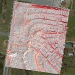
The GIS mapping services division of GEO Jobe has been quite active with UAV technology over the last year. We’ve turned to cutting edge hardware and software solutions to take to the sky and support some of our existing clients (and new ones) with imagery & analysis derived from UAV (drone) data acquisition.
Business Location Challenges: How GIS Can Help
Selecting the right location is a challenge for all kinds of businesses, not just those that serve customers directly. Things like the demographics and education level of the surrounding population who will be potential employees, schools in the area who train workers for particular professions, and the availability and quality of either affordable family housing […]
Engaging Missouri Constituents Through Mobile Technology
Imagine planning a fishing trip with family or friends and knowing exactly where to find the hot fishing spots and having the exact driving directions on how to get there. Imagine being able to purchase your hunting and fishing license right from your phone and store them offline.