Local government, utilities, College Campus and facility managers have a new resource at their disposal to help reduce costs associated with GIS mapping efforts and to keep their GIS land base current and up to date while also saving money.
The program is far less expensive than a traditional ortho project – “The drone based program GEO Jobe offers is designed for small areas of change. This keeps the county GIS current without having to fly and capture county-wide orthos every time a new development comes online.” Bobby Sullins, Project Manager for WWUD
There’s many reasons to look at UAV technology for your future data collection and GIS project needs. Companies, government, and consultants are turning to UAV technology for UAV based mapping and GIS update projects, taking advantage of the many benefits this technology provides for the team and for clients. Some common, UAV based mapping and GIS update projects and workflows that can benefit from employing UAV technology include: pre re and post construction and residential developments; utility (water tower) inspections; R-O-W mapping; airport asset inspections; ortho photography updates; College facility mapping and ortho creation, contour maps and more.
Why you need to consider a UAV technology for your next mapping project or 3D model creation. We share just 10 of the many reasons to consider a UAV-based collection project:
- UAV flights provide eyes that can reach and hover above specific sites
- Equipped with sensors, they can measure, transmit and store data – quickly!
- Data can be used to produce or update topographic and hydrographic maps, volumetric calculations for stockpiles, and flood insurance maps, among other
- overhead perspective and 360° panoramas relay a real-time scenario.
- Data can be used and rendered in Esri’s ArcGIS online web service and integrated into ArcGIS (or other systems) for further processing
- Images are high resolution and serve a variety of users (and can be integrated into any enterprise GIS platform).
- Drones present no safety risk for the operator and eliminates risks to ground and air personnel
- Surveying firm McKim & Creed estimates a 60% cost savings using Esri’s Drone2Map over conventional survey techniques.
- UAS improved accountability, saved taxpayer money, did not disrupt construction operations
- Agencies and city managers can employ affordable orthophotography update projects, by flying and updating only the areas where change has like occurred rather than a costly update project that covers an entire region, territory, or county.
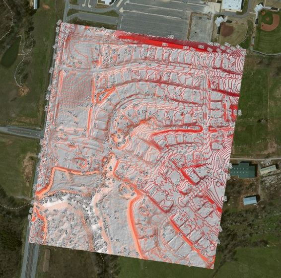
Recently, the team has had success producing an impressive 3D model as part of an aerial mapping and facilities inspection for the Meharry Medical College in Nashville, Tennessee. Using the high resolution data captured via low altitude UAV areal fly over the team has been able to put together photo realistic, 3D models for very large project areas (hundreds of acres in size) and this was no exception. GEO Jobe UAV also produced a 560+ acre digital ortho image update for Middle Tennessee State College (See below) – another example of a product that is a typical deliverable from a facilities mapping project.

UAV flown, digital orthophoto update, Middle Tennessee State Campus – Image: GEO Jobe
More About Geo Jobe UAV
The GEO Jobe crew currently has four FAA licensed UAV remote pilots experienced in UAV and mobile data collection techniques for orthophotography updating, corridor mapping, asset inventory, terrain modeling, 3D building design models and more. GEO Jobe supports clients with fleet of 4 drones using the latest UAV technologies. For more feel free to contact GEO Jobe AUV via tweet (dedicated UAV topic account @geojobeuav), connect via the UAV facebook page.
Source: GEO Jobe UAV Mapping Services
Of interest, see this inforgraphic describing benefits of UAV technology and more:

benefits of UAV