GIS user technology news

News, Business, AI, Technology, IOS, Android, Google, Mobile, GIS, Crypto Currency, Economics

  • Advertising & Sponsored Posts
    • Advertising & Sponsored Posts
    • Submit Press
  • PRESS
    • Submit PR
    • Top Press
    • Business
    • Software
    • Hardware
    • UAV News
    • Mobile Technology
  • FEATURES
    • Around the Web
    • Social Media Features
    • EXPERTS & Guests
    • Tips
    • Infographics
  • Blog
  • Events
  • Shop
  • Tradepubs
  • CAREERS
You are here: Home / Archives for TCarta

TCarta Announces Satellite Derived Bathymetry Product to Supplement Official Nautical Charts in Shallow Coastal Zones

February 21, 2025 By GISuser

Unveiling at Esri FedGIS

Filed Under: Around the Web, Business Tagged With: announces, around, bathymetry, business:, charts, coastal, derived, nautical, official, product, satellite, shallow, supplement, TCarta, the, web, zones:

TCarta Provides High-Tech Solution to Ship Groundings in Coastal Waters

October 3, 2024 By GISuser

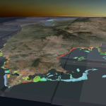
DENVER, Colorado, 3 October 2024 – Multiple recent incidents in which naval and commercial vessels ran aground have highlighted the dangers of maritime operations in shallow or poorly charted coastal waters. TCarta Marine of Denver offers a cost-effective, environmentally safe solution using Earth observation satellites to derive accurate water depth measurements in near-shore areas.

Filed Under: * PRESS Tagged With: around, coastal, groundings, high-tech, press, provides, ship, solution, TCarta, the, waters, web

TCarta Plans Bathymetric Mapping Workshop for Jamaica with Seabed 2030 Funding

February 5, 2024 By GISuser

DENVER, Colorado, 5 February 2024 – TCarta Marine, a global provider of hydrospatial products and services, will conduct a week-long coastal bathymetric mapping workshop for hydrographic surveyors in Jamaica. The workshop will be hosted by the Jamaica National Land      Agency (NLA) and funded by The Nippon Foundation-GEBCO Seabed 2030 project.

Filed Under: Business, DATA Tagged With: 2030, bathymetric, Business, Data, for, funding, Jamaica, Mapping, plans, seabed, TCarta, with, Workshop

Marine Institute and TCarta Student Internship Program Makes Major Data Contribution to Seabed 2030 Project

November 8, 2023 By GISuser

Marine Institute and TCarta Student Internship Program Makes Major Data Contribution to Seabed 2030 Project

TCarta Marine, a global provider of hydrospatial products and services, has delivered three major satellite derived bathymetry (SDB) data sets to The Nippon Foundation-GEBCO Seabed 2030 project. Students in Canada participating in a 2023 summer internship program created the SDB products for the entire coastline of Madagascar, Newfoundland, and two Canadian Arctic research areas.

Filed Under: Business, Environment, Top Text Lead Story Tagged With: Marine, TCarta

TCarta to Deliver Satellite Derived Bathymetry for 13 Regions to National Geospatial-Intelligence Agency

June 15, 2023 By GISuser

Work will be completed under contract to Maxar

Filed Under: Business, Featured TOP PR Tagged With: maxar, TCarta

TCarta Hosting Coastal and Littoral Zone Mapping Workshop at GEOINT 2023

May 15, 2023 By GISuser

Registration Open Now

Filed Under: Business, Events Tagged With: events, GeoINT, TCarta

TCarta Opens Canadian Affiliate Office to Provide Hydrospatial Mapping Services Across Canada

June 6, 2022 By GISuser

Baffin Island Project Announced

Filed Under: Business, Top Press Tagged With: TCarta

TCarta to Showcase Satellite-Derived Bathymetric Products on Absolute Ocean Platform at GEOINT 2022

April 13, 2022 By GISuser

https://gisuser.com/wp-content/uploads/2022/04/TCarta-GEOINT-Image.jpg

Presentations Include Trident Tools, ICESat-2 Data 

Filed Under: Business, Earth Imaging - Remote Sensing, LiDAR, Top Press Tagged With: TCarta

TCarta Delivers Satellite-Derived Bathymetry to NOAA for U.S. Coastal Mapping Pilot

May 3, 2021 By Editor

2m SDB in Nantucket Sound, MA, produced using WorldView satellite imagery with ICESat-2 tracks overlaid.

Validated with ICESat-2 Laser Data

Filed Under: Business, Earth Imaging - Remote Sensing Tagged With: Coastal Mapping, NOAA, TCarta

TCarta Awarded NOAA Grant to Enhance Satellite Derived Bathymetry Technology in Alaskan Waters

March 8, 2021 By Editor

Focus on Accuracy

Filed Under: Business, Earth Imaging - Remote Sensing, Top Text Lead Story Tagged With: TCarta

Next Page »

Recent Industry News

The First 90 Days Tell the Truth: What Hospitality Fitouts Reveal After Opening

March 27, 2026 By GISuser

Beyond the Blur: How Frosted Glass Film Is Quietly Redefining Modern Melbourne Spaces

March 27, 2026 By GISuser

The Early Build Decisions That Quietly Shape Life in Your Home Years Later

March 27, 2026 By GISuser

The Complete Guide to Buying Xxxxxxxxl Size Cxx Clothing: Fit, Comfort and Style Tips 

March 16, 2026 By GISuser

Hot News

State of Data Science Report – AI and Open Source at Work

HERE and AWS Collaborate on New HERE AI Mapping Solutions

Virtual Surveyor Adds Productivity Tools to Mid-Level Smart Drone Surveying Software Plan

Categories

Copyright gletham Communications 2015 - 2026

Go to mobile version