
Red Sea is First Data Set
TCarta Delivers Satellite-Derived Mangrove Health Assessment to Abu Dhabi
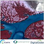
BRISTOL, United Kingdom, 24 October 2018 – TCarta, a global provider of geospatial products and services, has been commissioned by Environment Agency – Abu Dhabi (EAD) to carry out a landmark mangrove health assessment covering the entire Emirate of Abu Dhabi. The assessment contains mangrove condition information derived from high-resolution multispectral satellite imagery.
TCarta Delivers Satellite-Derived Land/Sea Floor Surface Models for Caribbean Disaster Recovery

BRISTOL, United Kingdom, 17 April 2018 – TCarta, a global provider of marine geospatial products, has delivered pre- and post-disaster surface models for the Caribbean islands of Antigua and Barbuda for use in Hurricane Irma recovery efforts. The satellite-derived surface models contain seamless datasets of onshore elevation and offshore water depth measurements for each island.