10 September, 2019, Bologna Italy – SITECO Infomatica SRL will be attending Intergeo 2019 in Stuttgart, Hall 3, Stand B3.025, showcasing the Road-Scanner family of Mobile Mapping Systems and the NEW software release of Road-SIT Survey.
Robotic Riverbed Survey Vessel Tracked with FOCUS 35 Total Station
Preston, Lancashire, UK (November 28, 2016) To increase public interest and involvement in protecting and improving the Ribble River, the Ribble Rivers Trust recently commissioned a bathymetry survey of a notable section of the riverbed.
Topcon introduces Elite Survey Suite
Speed, ease-of-use and integration key to design
SETTOP BATTERY II: Safety and high performance for your surveying instruments
The Settop Battery II is a high-capacity power system designed for total stations and GNSS receivers.
National Mall Employs High Tech Surveying for 21st-Century Preservation
Global NGO, CyArk, is providing preservation data captured in 2013 to guide efforts of National Park Service and private partner
Blue Marble Releases GeoCalc SDK Version 7.2 with Updated Projection Definitions and Support for WKT 2
Hallowell, Maine – April 5, 2016 – Blue Marble Geographics (bluemarblegeo.com) is pleased to announce the immediate availability of version 7.2 of the GeoCalc Software Development Kit (SDK).
FOCUS 35 Shines in Nighttime Topographic Survey
Leicestershire, March 22, 2016 – When a topographic survey for the main runway of the East Midlands International Airport was performed during nighttime closure, the Spectra Precision FOCUS 35 robotic total station turned in a stellar performance.
Alaska Mapping Project Passes 50 Percent Mark – New elevation for Denali recorded
Dewberry, a national professional services firm, has announced that mapping efforts under the Alaska Statewide Digital Mapping Initiative (SDMI) have surpassed the 50 percent mark, with new maps now complete for many of the state’s high-priority areas. Recent achievements include the recording of a revised elevation for Denali (formerly Mount McKinley) in Denali National Park.
Event Tip – Surveyors Rendezvous 2015, Bellingham, WA
An event of interest, particularly those of you in the Pacific NW as the annual Surveyor Rendezvous takes place Sept 9-13 in Bellingham, Washington
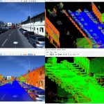
Routescene LidarPod enables new approach to surveying
The Routescene® proposition to transform the approach to surveys across the world is taking hold. Identifying massive potential and a gap in the market, Routescene® developed the LidarPod®, market-leading 3D mapping technology designed specifically for use on Unmanned Aerial Vehicles (UAVs). Launched at Intergeo 2014 in Berlin, the highly acclaimed LidarPod® has attracted interest and […]