GIS user technology news

News, Business, Technology, Mobile, GIS, Crypto Currency, AI, Economics

  • PRESS
    • Submit PR
    • Top Press
    • Business
    • Software
    • Hardware
    • UAV News
    • Mobile Technology
  • FEATURES
    • Around the Web
    • Social Media Features
    • EXPERTS & Guests
    • Tips
    • Infographics
  • Events
  • CAREERS
  • Advertising and Sponsored Posts
    • Advertising and Sponsored Posts
    • Submit Press
  • Shop
  • Tradepubs
  • Around the Web
  • Cool Links
You are here: Home / Archives for Maps

New Power BI custom visual for embedding interactive maps

February 24, 2020 By GISuser

Cadcorp SIS WebMap for Power BI supports organisations wanting to use a range geospatial data in their Microsoft Power BI reports

Filed Under: Software Tagged With: Cadcorp, custom, embedding, for, interactive, Maps, New, Power, software:, visual

10 Different Types of World Maps

February 17, 2020 By GISuser

10 Different Types of World Maps

A person who makes maps is called a cartographer. The Greeks are known to be the pioneers of map making with proper mathematical footing.

Filed Under: Maps and Cartography Tagged With: Maps

5G Wireless Mapping Puts LAND INFO on Inc. 5000 List of Fastest Growing Companies

August 22, 2019 By GISuser

LAND INFO automated mapping technology, including Object Based Image Analysis and Artificial Intelligence, generated this 3D data set containing multi-tiered building and tree vectors for downtown Chicago

DENVER, Colorado, USA, 22 August 2019 – LAND INFO Worldwide Mapping LLC has been named to the 2019 Inc. 5000 list of fastest-growing private companies in the United States. The firm credits its explosive three-year revenue growth to recent contract wins supporting 5G wireless network mapping.

Filed Under: Business Tagged With: landinfo, Maps

Ordnance Survey online art gallery opens

July 31, 2019 By GISuser

The current exhibition inlcudes this map Buzz Aldrin is checking out below

First exhibition is a modern take on one of the world’s oldest artforms

Filed Under: Business, Maps and Cartography Tagged With: Maps, Ordnance Survey

Esri Story Map Explores Communities Potentially Impacted by Changes to Immigration Policy

February 16, 2018 By Editor

When elected officials talk about changing our immigration system, just who and where are people affected? That’s the question Esri is trying to help answer with a new interactive story map that explores communities with the highest shares of non-citizen residents and DACA recipients.

Filed Under: Maps and Cartography Tagged With: ESRI, Maps, story map

GfK releases new digital maps for Australia

February 5, 2018 By GISuser

gfk

GfK has released a new, completely overhauled map edition for Australia. Along with more detailed coastlines, the new digital maps reflect the latest status of the country’s more than 57,000 statistical areas and 357,000 mesh blocks. Detailed, up-to-date digital maps are an important prerequisite for location-based market analyses.

Filed Under: DATA Tagged With: Australia, GfK, Maps

Hurricane Irma Emergency Response WebMaps

September 8, 2017 By GISuser

hurricane Irma

There’s many maps, webmaps and web resources available online to support the response to Hurricane Irma. These range for traffic maps, evacuation routes, shelter locations, wind speed and direction information and much more. The following is a sample of some map resources that have been compiled by the crew at GEO Jobe

Filed Under: Emergency Response, Maps and Cartography Tagged With: hurricane, irma, Maps

Feature – States’ Rights: A Sure Bet on Location

August 8, 2017 By Troy Lambert

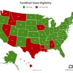
This October, the Supreme Court will hear a landmark case on the repeal of the Professional and Amateur Sports Protection Act (PASPA) passed by Congress in 1992. The act prohibits sports betting in all states except Nevada, Oregon, Montana, and Delaware. These states were grandfathered in, and therefore exempt to the law.

Filed Under: Business, EXPERTS, Maps and Cartography, Top Features, Top Press Tagged With: lambert, location, Maps

MapThis shares Wildfire Maps – Maps, WebMaps and Resources for #BCwildfire Updates

August 4, 2017 By GISuser

From GEO Jobe GIS – Recall, recently we shared the story of how our friends and colleagues at Esri small business startup, Echosec, supported their lead developer in building a BC wildfire public information ArcGIS online resource in order to help keep the public informed and safe. Building on that and after searching for additional resources, the […]

Filed Under: Around the Web, Emergency Response, EXPERTS, Map of the Day, Maps and Cartography, Tips, Top Press Tagged With: canada, Maps, wildfire

Updated US Topo maps for Kentucky from the USGS

May 25, 2016 By GISuser

US Topo maps for Kentucky from the USGS

New US Topo maps for Kentucky are now available in the USGS Store for free download. One of the main improvements is the inclusion of the U.S. Census Bureau’s Topologically Integrated Geographic Encoding and Referencing (TIGER) road data.

Filed Under: DATA Tagged With: kentucky, Maps, topo, USGS

« Previous Page
Next Page »


featured podcast

Recent Features

Space Flight Laboratory (SFL) Announces Successful Launch & Deployment of HawkEye 360’s Cluster 11

FOSS4G NA 2024: The Premier Open Source Geospatial Conference Returns to St. Louis, September 9-11

Photographer Touch Reveal the Top Cameras, Lenses, and Photo Editing Tools of 2022

Digitalization and Simulation at the North Pole

Natural Gas District & GIS-Centric Asset Management

More Posts from this Category

Categories

Recent Posts

  • How Technology Has Changed Horse Racing Betting Forever
  • Why Choose Rust-Resistant Metal Floor Vents?
  • Why Fast AI Note-Taking Is Vital for Mental Health Patient-Centered Care
  • Mapping the Rise of Online Betting in Africa
  • Importance of Chinese Technical Translations For Your Automotive Business

RSS Career Tips

  • Four Characteristics of the Best Virtual Employees
  • 28 Tools to Conquer the Social Media Recruiting World
  • 8 Questions Employers Should Ask About Coronavirus
  • Jobcase Launches Free Unemployment Resource Center for Workers Impacted by COVID-19
  • Must-Have Gadgets and Technology for the Remote Office Worker

RSS Tech pubs

  • Turn Market Pressure Into a Strategic Advantage
  • Email Integration for Freight Brokers
  • 8 Areas to Improve Your FTL Freight Brokerage

RSS Computers

  • How the Cloud is Reshaping Virtual Desktops
  • Millennials as Brand Advocates - New Research Study Results
  • Vehicles Best Practices Installation Guide

RSS HR Tips

  • Public Works & Utilities
  • Hybrid Work
  • AWS GovCloud (US) Celebrates 10th Anniversary and a Decade of Digital Transformation in the Federal Government

RSS Gov Tech

  • Government Procurement: Technology: Solving Problems for Government
  • IWCE News Desk: Public Safety Communications
  • IWCE News Desk: Nemergent, Frequentis

RSS UAV news

  • DJI Matrice 4 Series Brings Intelligence to Aerial Operations
  • Virtual Surveyor Adds Productivity Tools to Mid-Level Smart Drone Surveying Software Plan
  • Nokia and Swisscom Broadcast to deploy largest Drones-as-a-Service network

RSS Geojobs

  • Senior Systems Administrator
Copyright gletham Communications 2011-2022

Go to mobile version