Since legalization in 2018, Canada’s cannabis industry has experienced rapid expansion. With this expansion comes an increased need for innovative solutions to optimize cultivation practices. Geographic Information Systems (GIS) technology is emerging as an essential solution, giving growers tools for making data-driven decisions to increase productivity, sustainability, and compliance while meeting compliance regulations. By combining […]
Release of the 2021 Atlas of Canada World Map
For over a century, the Atlas of Canada has provided Canadians with trusted geographic information about Canada and the world. From the first paper folio edition in 1906 to today’s digital and interactive online maps, the Atlas of Canada has provided insights and information to help everyone understand the world we live in, as well […]
52 Junior Astronaut Camp winners to train with astronauts and experts
May 25, 2021 – Longueuil, Quebec – From July 26 to 30, 2021, 52 young Canadians from across the country will virtually join astronauts, engineers and scientists from the Canadian Space Agency (CSA) for an exciting week of space training.
Space Software Firm to Support Climate Change Battle

Canadian space app developer Deploy Solutions will be returning to the GeoIgnite conference this month to unveil a new climate-focused prototype, as part of an Earth Day showcase at the Canadian national Geospatial event.
What Is GeoIgnite And What Does It Hold In 2021 For Canada’s Geospatial Industry?

GeoIgnite 2021 is back April 21-23rd, and Canada’s National Geospatial Conference is bigger and better than ever. Breaking new ground, the conference is free and the first three days are presented bilingually in French and English for the first time.
Event Tip – GeoIgnite 2021, Canada’s National Geospatial & Location Technology Conference

GeoIgnite 2021 is scheduled to take place April 2021 and will feature a career fair, April 14, Conference, April 21-23, and professional training and workshops, April 26-30
Esri Canada – Five Steps to Understanding the COVID-19 Impact on Your Organization

Esri Canada recently offered Cdn businesses this help to weather the pandemic.
Spring blossoms in the City of Victoria – Victoria, Canada Launches Cherry Blossom Map
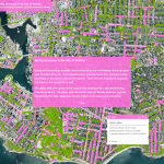
The City of Victoria has rolled out its annual map of blooming cherry and plum trees throughout the region. The interactive map pinpoints different types of blossoming trees across the city depending on the time of year. (Source: CFAX1070)
New Conference Will Help Bridge the Digital Divide
NORTH BAY, Ontario, Aug. 15, 2019 — Delivering broadband to rural and remote regions in Canada faces unique, complex challenges as compared to broadband deployments in urban settings.
The Government of Canada Announces Winners of the Smart Cities Challenge

OTTAWA, May 14, 2019 /CNW/ – By driving innovation in communities across the country, the Government of Canada is empowering communities to address the most pressing needs of their residents through data and connected technology.