
Integration with Airspace Link Provides UAS Pilots with Automated Approval to Fly in Controlled Airspace
Esri Partner Track Star Integrates ArcGIS Platform
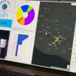
Fleet Tracking Company Uses Esri’s Platform as a Service to Scale Solution Development
Esri Joins Digital Twin Consortium

Organizations Can Use ArcGIS to Connect Virtual Models, Solving Business Challenges
Esri Federal GIS Conference Showcases How GIS Interconnects National Government

Annual Event Spotlights How Technology Empowers Staff and Collaboration Across Agencies
Esri Launches ArcGIS Platform

Comprehensive Location Services, Data, and Mapping Tools Are Available to Developers
I Got Vaccinated! Story Map Shares the Who & Where of #COVID-19 Vaccinations

A good story(map) story tip via our friend Joseph Kerski of Esri… “Our health team at Esri worked with GISCorps who is hosting this application where people can share their vaccination stories and approving submissions.”
Anil Jayavarapu Achieves Esri Certification in ArcGIS Utility Network Specialty
McLean, Virginia – January 6, 2021 – Avineon, Inc. (Avineon), a global provider of spatial intelligence, engineering support services, and digital modernization, congratulates Anil Jayavarapu on successfully achieving the ArcGIS Utility Network Specialty certification designated by Esri. As an Esri Gold Business Partner and recipient of the company-wide Esri Utility Network Management Specialty Partner, our customers rely on Avineon for envisioning, […]
Newmont Corporation Adopts Esri’s Site Scan for ArcGIS
Partnership with Esri Provides Drone Mapping Solution to Mine Sites Worldwide
Esri Silver Business Partner, Bay Park DS, Custom GIS Professional Services for Non-Profits now Available in the ArcGIS Marketplace
Esri providers deliver best-in-class consulting, development services, and more
Esri Releases New Book Showcasing GIS in Scientific Research
How Geospatial Technology Can Be Applied to a Variety of Rigorous Methodologies