GIS user technology news

News, Business, AI, Technology, IOS, Android, Google, Mobile, GIS, Crypto Currency, Economics

  • Advertising & Sponsored Posts
    • Advertising & Sponsored Posts
    • Submit Press
  • PRESS
    • Submit PR
    • Top Press
    • Business
    • Software
    • Hardware
    • UAV News
    • Mobile Technology
  • FEATURES
    • Around the Web
    • Social Media Features
    • EXPERTS & Guests
    • Tips
    • Infographics
  • Around the Web
  • Events
  • Shop
  • Tradepubs
  • CAREERS
You are here: Home / Archives for Cartography

Artistic Cartography: The Business Value of Aesthetically Pleasing Maps in Marketing

November 19, 2024 By GISuser

Maps have always been a trusted tool for navigation and exploration, but in today’s marketing world, they’re becoming something far more creative. Businesses are transforming maps into artistic masterpieces to engage audiences and stand out from competitors. This trend, known as artistic cartography, blends functionality with beauty, turning maps into powerful marketing assets that tell […]

Filed Under: Around the Web Tagged With: aesthetically, around, artistic, business:, Cartography, Maps, Marketing, pleasing, the, value, web

Event / Webinar Tip – The Avenza User Conference #AvenzaUC2021

April 16, 2021 By Editor

The Avenza User Conference is a free, day-long virtual conference for map makers, GIS enthusiasts, and geospatial professionals worldwide who share a common interest in Avenza mapping technology.

Filed Under: Events, Webinars Tagged With: Avenza, Cartography, event, Webinar

Map of the Day – New York City Transit Map, 1917

January 7, 2016 By GISuser

Map of the Day - New York City Transit Map, 1917

In January 6th, 2016, The New York Public Library made over 187K digital items in the public domain available for high resolution download. This is one of many experiments by the NYPL Labs to help patrons understand and explore what was contained in that release.

Filed Under: Around the Web, Map of the Day, Maps and Cartography Tagged With: 1917, AND, around, Blockquotes, Cartography, city, day, map, map of the day, Maps, MOTD, New, New York, NYC, the, transit, web, york

New Esri Book Teaches the Principles of Good Map Design

December 29, 2015 By GISuser

map design

Redlands, California—December 29, 2015—Mapmakers should always strive to create maps that look great and get their message across clearly and succinctly. According to Esri president Jack Dangermond, more emphasis today needs to be placed on map design, especially on the web. “We need to spend more time designing maps and not just producing them,” Dangermond […]

Filed Under: EDU, Maps and Cartography, Top Press Tagged With: Cartography, map design

Unique Hand Drawn Map of London – Ten Years in the Making

October 13, 2015 By GISuser

Unique Hand Drawn Map of London

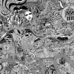
LONDON, October 13, 2015 – Fuller, aka Gareth Wood, a British artist, has drawn a meticulous map of London, which has taken an astonishing ten years to complete.

Filed Under: GISuser Promotion, Maps and Cartography, Top Press, video Tagged With: Cartography, London, map

Ever wonder to yourself, “Where on Earth?” Enter The Functional and Beautiful MapWheel

August 11, 2015 By GISuser

MapWheel is a new, functional and attractive piece of home decor intended to trigger fond memories, provoke conversations

Ever wonder to yourself, “Where on Earth?” Enter The Functional and Beautiful MapWheel — Simply put, according to the creators, A MapWheel is a new, functional and attractive piece of home decor intended to trigger fond memories, provoke conversations and celebrate locations that have significance to you. Indeed they are creative and I have no […]

Filed Under: Around the Web, Business, Maps and Cartography, THE EDITOR, Tips, Top Features Tagged With: Art, Cartography, kickstarter, mapwheel, travel

Track Wildfires Across the Western US with Interactive Esri Maps

August 4, 2015 By GISuser

Track Wildfires Across the Western US with Interactive Esri Maps

A couple of fine resources are available to the public via Esri in an effort to track and keep tabs on the terrible state of wildfires in the western US

Filed Under: Around the Web, Emergency Response, Environment, Maps and Cartography, Top Press Tagged With: across, AND, arcgis online, around, Cartography, emergency, environment, ESRI, interactive, Maps, press, response, the, top, track, web, western, wildfire map, wildfires, with

Map Tip – Amazing subway Style Maps

March 24, 2015 By GISuser

River maps - Subway Map Style

Like many of you, I’m a closet map junkie! I simply love maps and anything that remotely resembles a map! I have a particular fondness for “Subway” style maps – you know, a work of cartographic excellence that tells a story using the familiar London Underground style of cartography

Filed Under: Around the Web, Maps and Cartography, Tips, Top Features, Top Press Tagged With: Cartography, Maps, subway maps

Have Infographics and Data Visualizations Ruined Good Map Design?

January 18, 2015 By GISuser

ugly map

Cartographers take pride in their work, typically applying all the rules and principles of good cartographic design to their work, all in an effort to make people want to look at and appreciate their work (See Esri, Make Maps People Want to Look at). 

Filed Under: **Front Page, *BLOG, *FEATURES, Around the Web, Featured Event, FrontPage Leader, Maps and Cartography, THE EDITOR, Top Features, Top Press Tagged With: bad map, Cartography, map, map design, map production

New NASA Images Highlight U.S. Air Quality Improvement

July 10, 2014 By Editor

Anyone living in a major U.S. city for the past decade may have noticed a change in the air. The change is apparent in new NASA satellite images unveiled this week that demonstrate the reduction of air pollution across the country. After ten years in orbit, the Ozone Monitoring Instrument (OMI) on NASA’s Aura satellite has been […]

Filed Under: Maps, Cartography, and awesome Data Visualizations Tagged With: and awesome Data Visualizations, Cartography, Maps, New NASA Images Highlight U.S. Air Quality Improvement, News

Next Page »

Recent Posts

  • Small Business, Big Impact: Your Guide to Low Quantity Swag
  • How Tech Platforms Like Telegram Enable New Revenue Models
  • 6 Reasons Jobs in Pune are Your Gateway to Career Growth and Skill Mastery
  • Reading Worksheets: Build Grade 1 Students’ Foundation in Word Families
  • Why PVC Sheets Are a Smart Choice for Outdoor Tech and Field Equipment
  • Location-Based Gaming: Integrating Geospatial Tech with Entertainment
  • Decoding Slot Paytables: Your Guide to Winning Combinations
  • Field Mapping in Remote Queensland: Why Mobile Basecamp Makes Sense
  • B2B Messaging That Sticks Without the Fluff
  • Streamline Your Success: The Power of a Full-Service Marketing Agency

Recent Features

Space Flight Laboratory (SFL) Announces Successful Launch & Deployment of HawkEye 360’s Cluster 11

FOSS4G NA 2024: The Premier Open Source Geospatial Conference Returns to St. Louis, September 9-11

Photographer Touch Reveal the Top Cameras, Lenses, and Photo Editing Tools of 2022

Digitalization and Simulation at the North Pole

Natural Gas District & GIS-Centric Asset Management

More Posts from this Category

Categories

RSS Career Tips

  • Four Characteristics of the Best Virtual Employees
  • 28 Tools to Conquer the Social Media Recruiting World
  • 8 Questions Employers Should Ask About Coronavirus
  • Jobcase Launches Free Unemployment Resource Center for Workers Impacted by COVID-19
  • Must-Have Gadgets and Technology for the Remote Office Worker


featured podcast

RSS Tech pubs

  • Shaping the Future of Higher Education: AI and Evolving Student Needs
  • Still Not Modeling Your Energy Storage Projects? It Could Be Costing You Millions.
  • Unlock Payment Integrity in 2026: A Smarter Path for Community Health Plans

RSS Computers

  • How the Cloud is Reshaping Virtual Desktops
  • Millennials as Brand Advocates - New Research Study Results
  • Vehicles Best Practices Installation Guide

RSS HR Tips

  • AWS GovCloud (US) Celebrates 10th Anniversary and a Decade of Digital Transformation in the Federal Government
  • Exploring the Impact of COVID-19 on Customer Behavior
  • The Pivot to 100% Remote Training in the Contact Center

RSS Gov Tech

  • 10 Legal Jobs You Can Get Without a Law Degree
  • J.D. Power Examines How the Inflation Reduction Act Reshapes EV Landscape
  • Making Telehealth Work for You: The Ultimate Guide

Copyright Spatial Media LLC 2003 - 2015

Go to mobile version