GIS user technology news

News, Business, AI, Technology, IOS, Android, Google, Mobile, GIS, Crypto Currency, Economics

  • Advertising & Sponsored Posts
    • Advertising & Sponsored Posts
    • Submit Press
  • PRESS
    • Submit PR
    • Top Press
    • Business
    • Software
    • Hardware
    • UAV News
    • Mobile Technology
  • FEATURES
    • Around the Web
    • Social Media Features
    • EXPERTS & Guests
    • Tips
    • Infographics
  • Blog
  • Events
  • Shop
  • Tradepubs
  • CAREERS
You are here: Home / *BLOG / Around the Web / Map Tip – Amazing subway Style Maps

Map Tip – Amazing subway Style Maps

March 24, 2015 By GISuser

Like many of you, I’m a closet map junkie! I simply love maps and anything that remotely resembles a map! I have a particular fondness for “Subway” style maps – you know, a work of cartographic excellence that tells a story using the familiar London Underground style of cartography

Well, if this is also you then this is your lucky day as I’ve stumbled onto a WEALTH of Subway Style Maps via this interesting article on Vox by Phil Edwards – 15 subway-style maps that explain everything but subways

The article shares stories and images from a number of projects that range from maps of the National Park system, The Solar System, Musicians, The Human Body, and my favorite, maps of North American Rivers via Somethingaboutmaps – pure awesomeness!

River maps - Subway Map Style

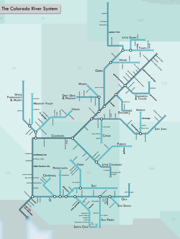
River maps – Subway Map Style (Image Credit: Daniel Huffman)

From the Author of the River Maps- Rivers have been a key part of urban life for centuries. They have provided us with drinking water, protection, and a transit network that links us from one settlement to the next. I wanted to create a series of maps that gives people a new way to look at rivers: a much more modern, urban type of portrayal. So I turned to the style of urban transit maps pioneered by Harry Beck in the 1930s for the London Underground. Straight lines, 45º angles, simple geometry. The result is more of an abstract network representation than you would find on most maps, but it’s also a lot more fun. The geography is intentionally distorted to clarify relationships. I think it helps translate the sort of visual language of nature into a more engineered one, putting the organic in more constructed terms. Not every line depicted is navigable, but all are important to the hydrological systems shown.

See the River Maps (Subway Map Style) HERE and you can contact the author @pinakographos

Via ALL the subway Style maps HERE

[Tweet “Map Tip – Amazing subway Style Maps”]


Filed Under: Around the Web, Maps and Cartography, Tips, Top Features, Top Press Tagged With: Cartography, Maps, subway maps

Editor’s Picks

geojobs

GeoJobs.BIZ Employment and Career Resource for GIS, Surveying, and Mapping Professionals

DigitalGlobe Top Images from 2014 – The fourth annual Top Image contest

Mapping Water Use: Landsat and America’s Water Resources

Mapping Reform: Where are Things Likely to Change?

See More Editor's Picks...

Recent Industry News

The Drift Between Early Notes and Final Case Files in Abuse-Related Legal Support

April 29, 2026 By GISuser

Aerial Surveys Int’l and Global Marketing Insights to Present GEOINT 2026 Workshop on Multi-Domain Geospatial Fusion for Automated Infrastructure Monitoring

April 24, 2026 By GISuser

Why Timing Matters More Than You Think With Spray Seal (And Why People Often Get It Slightly Wrong)

April 22, 2026 By GISuser

The Quiet Planning Stage Most People Don’t See When Building a Pool in Brisbane

April 22, 2026 By GISuser

Hot News

State of Data Science Report – AI and Open Source at Work

HERE and AWS Collaborate on New HERE AI Mapping Solutions

Virtual Surveyor Adds Productivity Tools to Mid-Level Smart Drone Surveying Software Plan

Categories

Copyright gletham Communications 2015 - 2026

Go to mobile version