GISuser.com

GIS and Technology news for mapping professionals

  • PRESS
    • Submit PR
    • Top Press
    • Business
    • Software
    • Hardware
    • UAV News
    • Mobile Technology
  • FEATURES
    • Around the Web
    • Social Media Features
    • EXPERTS & Guests
    • Tips
    • Infographics
  • Events
  • CAREERS
  • Advertise
    • Advertise
  • Blog
  • Shop
  • Tradepubs
You are here: Home / **Front Page / GISuser Promotion / Unique Hand Drawn Map of London – Ten Years in the Making

Unique Hand Drawn Map of London – Ten Years in the Making

October 13, 2015 By GISuser

LONDON, October 13, 2015 – Fuller, aka Gareth Wood, a British artist, has drawn a meticulous map of London, which has taken an astonishing ten years to complete.

'London Town' by British Artist Fuller, aka Gareth Wood. The original art work is hand drawn using black ink on cotton archival board and measures 92cm x 116cm. The work is a mesmerising kaleidoscope to our association with youth, adolescence and progress into adulthood. Fuller lived, breathed and morphed into the capital to channel its character onto the map. (PRNewsFoto/British artist Fuller)

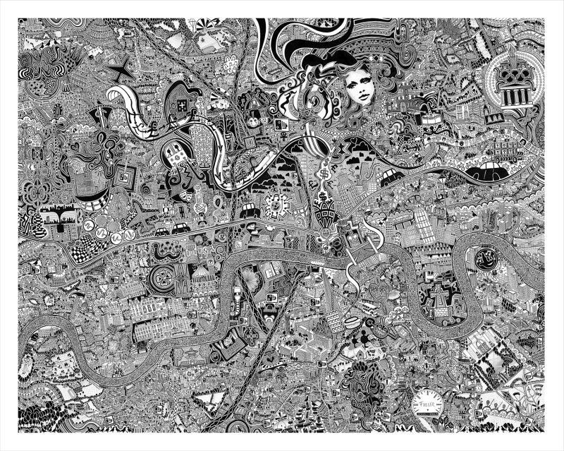
‘London Town’ by British Artist Fuller, aka Gareth Wood. The original art work is hand drawn using black ink on cotton archival board and measures 92cm x 116cm. The work is a mesmerising kaleidoscope to our association with youth, adolescence and progress into adulthood. Fuller lived, breathed and morphed into the capital to channel its character onto the map. (PRNewsFoto/British artist Fuller)

The work is peppered with comments on contemporary society, though personal thoughts and memories are given almost equal prominence. Unveiled in London earlier this month, it has already taken on an urban legend quality. The piece ‘London Town’, is instantly recognisable, not by the obvious landmarks, but by the hedonistic, enchanting character of the metropolis that Fuller communicates.

The artist lived, breathed and morphed into the capital city to channel its character onto the map. Delve into the cryptic drawings of London Town; the unstoppable skyscrapers, dingy underground clubs, its decadence, the infinite energy, creativity, the expansion, its systems and its future.  London Town is an emotional conversation that you can join, read, experience and create new. It is a result of Fuller’s project, Fuller Maps, which has seen him drawing a series of intricate maps that narrate and observe the identity of places. He has previously completed a map of Bristol, which took 4 years to create. Fuller describes his practice as ‘making a collection of cartographical love letters.’ His past work has been included in the Bristol Museums Historical Map Archive.

‘London Town’ can next be seen at the ‘Flux Exhibition’, Royal College of Art, London, December 11th – 14th For more information about Fuller’s art please visit http://www.fullermaps.com

Fuller created a short film whilst cycling around London on his explorations, which can be viewed here: https://www.youtube.com/watch?v=ey-Eh_uzRpY

The ten chimes from Big Ben featured in the film symbolise the ten year period in which it was drawn.

Background information

Fuller Maps is a series of works by British artist Fuller, aka Gareth Wood (b.1980). Fuller draws intricate maps that narrate and observe the identity of places. Using extensive research, local knowledge and lived experience, he immerses himself within a place to understand its complex personality. Taking on average five years to produce, Fuller meticulously creates pen drawings that exhibit pockets of narrative on contemporary society. They are entwined with stories, curiosities, factoids and personal memories. By mapping events Fuller provides a subjective account which is instantly relatable. In doing so, the artwork places prominence on shared knowledge and experience, a distinctive characteristic of Fuller’s work.

Contact email: hello@fullermaps.com

SOURCE British artist Fuller


Related Articles on GISuser:

  • Have Infographics and Data Visualizations Ruined Good Map Design?Have Infographics and Data Visualizations Ruined Good Map Design?
  • Ordnance Survey has created a map of Great Britain using Minecraft and OS OpenDataOrdnance Survey has created a map of Great Britain using Minecraft and OS OpenData
  • What’s the Best Navigation Tool in London?What’s the Best Navigation Tool in London?
  • Event / Webinar Tip – The Avenza User Conference #AvenzaUC2021Event / Webinar Tip – The Avenza User Conference #AvenzaUC2021
  • MapBusinessOnline Issues USA Map Update of COVID-19 Vaccination ProgressMapBusinessOnline Issues USA Map Update of COVID-19 Vaccination Progress
  • Monitor the World’s Air Pollution – Real Time Air Quality Index MapMonitor the World’s Air Pollution – Real Time Air Quality Index Map

Filed Under: GISuser Promotion, Maps and Cartography, Top Press, video Tagged With: Cartography, London, map


Editor’s Picks

GIS and History: Using the Past to Inform the Present

GIS and History: Using the Past to Inform the Present

Juniper Systems’ New Rugged Handheld Offers Unparalleled Efficiency for Data-Intensive Application

Microsoft unveils the future of Windows

Hardware Spotlight – HP Z240 SFF Turbo Workstation

See More Editor's Picks...

Feed

  • RSS


GIS jobs


Recent Features

Digitalization and Simulation at the North Pole

Natural Gas District & GIS-Centric Asset Management

5 Ways Technology Is Affecting The Sharing Economy

Spotlight – Township Canada: Explore Canadian Legal Land Descriptions on a Map

GeoGeeksinCars – The one in “Tippy” the right-hand drive Mitsubishi, at DevSummit

More Posts from this Category

Categories

Recent Posts

  • A treadmill is one of the most popular fitness equipment
  • 3 Things to Help You Become a Software Engineer
  • Esri Announces Winners of the 2022 ArcGIS Online Competition
  • KBC WhatsApp Lottery Winner 2022 List – KBC Head Office Number +19188444477 – KBC Sim Card Lucky Draw 2022
  • Animation explainer for a trading application

RSS Career Tips

  • Four Characteristics of the Best Virtual Employees
  • 8 Questions Employers Should Ask About Coronavirus
  • Jobcase Launches Free Unemployment Resource Center for Workers Impacted by COVID-19
  • Must-Have Gadgets and Technology for the Remote Office Worker
  • Must-Have Gadgets and Technology for the Remote Office Worker


shop for geogeek swag

RSS Tech pubs

  • Top Tips and Tricks: Windows 11
  • The 2022 State of the Data Center Report
  • What is Network Security?

RSS Computers

  • The Essentials of Information Security Kit: Includes a Free PC Security Handbook - 2nd Edition eBook
  • The Idiot's Ultimate Guide to Build Your Own PC
  • Windows... On Speed

RSS HR Tips

  • Measuring and Managing Employee Experience
  • At Work: The 2022 Workplace Trends Report
  • The 2022 Guide To Creating A Great Visitor Experience

RSS Gov Tech

  • The Bipartisan Infrastructure Bill: How you can win more bids
  • How Connected Vehicle Data Can Transform Public Sector Decision-Making
  • Getting started with personalization at scale

RSS UAV news

  • Draganfly Deploys Versatile Situational Assessment Drones to Ukraine
  • Ocean Specialists Inc. Launches “USVs as a Service” Business Line
  • UAS Drone Subsidiary, Duke Robotics’, Sniper Drone showcased at a leading International Airshow in the Asia Pacific Region

RSS Geojobs

  • IT Endpoint Lead
Copyright Spatial Media LLC 2003 - 2015