GIS user technology news

News, Business, AI, Technology, IOS, Android, Google, Mobile, GIS, Crypto Currency, Economics

  • Advertising & Sponsored Posts
    • Advertising & Sponsored Posts
    • Submit Press
  • PRESS
    • Submit PR
    • Top Press
    • Business
    • Software
    • Hardware
    • UAV News
    • Mobile Technology
  • FEATURES
    • Around the Web
    • Social Media Features
    • EXPERTS & Guests
    • Tips
    • Infographics
  • Blog
  • Events
  • Shop
  • Tradepubs
  • CAREERS
You are here: Home / Archives for * PRESS / Maps and Cartography

Women-Led, Volunteer Advocacy Group Engages Communities on Elections, Voting, through Maps

October 21, 2020 By Editor

An interesting tip comes to us through Esri. Using these innovative tools, visitors can also explore key voting issues in the 2020 race such as criminal justice , healthcare or the environment.

Filed Under: EXPERTS, Featured TOP PR, Maps and Cartography Tagged With: election, ESRI, Maps

Animated Map Highlights 10 Most Destructive Wildfires in California History

October 15, 2020 By Editor

10 Most Destructive Wildfires in California History

Animated Map Highlights 10 Most Destructive Wildfires in California History. The new map from Esri highlights wildfires that claimed the most lives and destroyed the most structures. 

Filed Under: Emergency Response, Maps and Cartography, Top Text Lead Story Tagged With: California, ESRI, Video, wildfire

From Volcanoes to Vineyards – New Geologic Map Reveals Portland’s Deep History

October 11, 2020 By Editor

Portland Geologic Map

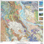
A new digital geologic map of the greater Portland-Vancouver-Hillsboro metropolitan area of Oregon and Washington being released today will support emergency response, conservation, agriculture and recreation.

Filed Under: Environment, Featured TOP PR, Maps and Cartography Tagged With: geology, Portland, USGS

Catalina Launches Interactive Cough, Cold & Flu and Allergy Heat Maps to Track Flare-Ups Nationwide

September 24, 2020 By Editor

Data Helps Marketers of Over-The-Counter Remedies and Retailers Pinpoint Marketing Opportunities

Filed Under: Business, Emergency Response, Maps and Cartography, Top Press Tagged With: flu

Tell your StoryMaps Story! #YourSDGstory

September 2, 2020 By GISuser

Are you a Story Mapper who loves to tell multi-media, feature-rich stories using the ArcGIS Online Story Maps tools? Well, here’s your opportunity to be recognized by sharing a story of your sustainable development goals. From Esri… Are you ready to join storytellers worldwide in a competition for positive change? For this year’s annual StoryMaps […]

Filed Under: Business, Featured TOP PR, Maps and Cartography Tagged With: arcgis, arcgisonline, competition, ESRI, storymap

Saudi Arabia Launches COVID-19 Dashboard Using Esri Technology

June 19, 2020 By GISuser

The Country’s Ministry of Health Is Tracking Pandemic Cases with New GIS Resources

Filed Under: Business, Government & OpenGov, Maps and Cartography Tagged With: COVID-19 Dashboard

Rebekah Jones @GeoRebekah , the fired GIS data scientist from Florida, Launches new #Coronavirus Dashboard, FloridaCOVIDAction

June 12, 2020 By GISuser

Florida's Community Coronavirus Dashboard

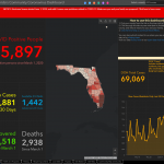
Remember Rebekah Jones, the fired GIS data scientist? Well, it seems she is following her passion to share public data and has deployed a new dashboard that shares coronavirus, health-related data from the state of Florida. Simply put… enter FloridaCOVIDAction.com.

Filed Under: Emergency Response, Maps and Cartography, Top Press Tagged With: coronavirus, dashboard, Florida

World Oceans Week and Mapping “Hope Spots”

June 10, 2020 By GISuser

As part of World Oceans Week, on Monday, June 8, Esri is teamed up with Napa, Calif.-based Mission Blue to map “Hope Spots” to preserve protected marine areas. Using Esri’s ArcGIS, Mission Blue is able to identify areas to inspire community engagement and engage policymakers in conservation efforts.

Filed Under: Earth Imaging - Remote Sensing, Environment, Maps and Cartography, Top Press Tagged With: earth, environment, ESRI

Finnish Space Data Company Terramonitor launches a Web Store

May 28, 2020 By GISuser

Finnish Space Data Company Terramonitor launches a Web Store

Terramonitor launches a Web Store that provides easy access to analysis-ready satellite images and up-to-date satellite maps. By processing thousands of satellite images per day with AI and cloud computing, Terramonitor provides revolutionary tools for monitoring and analyzing the globe from space.

Filed Under: Business, DATA, Earth Imaging - Remote Sensing, LiDAR, Maps and Cartography, Top Text Lead Story Tagged With: space data, Terramonitor

Rand McNally Releases a New Edition of the Iconic Road Atlas

April 21, 2020 By GISuser

The new 97th edition helps would-be travelers plan for better days

Filed Under: Business, Maps and Cartography Tagged With: Road Atlas

« Previous Page
Next Page »

Recent Industry News

Eagleview White Paper Warns: Geospatial Intelligence Is About to Change Forever

March 4, 2026 By GISuser

Can You Use A Bong As A Dab Rig? What You Should Know

March 3, 2026 By GISuser

This advancement, which will save customers time and money, also  is a critical step towards Eagleview’s goal of building fully remote, scalable property intelligence and turning aerial data into actionable, interactive 3D models for planning, assessment, and decision-making.

February 26, 2026 By GISuser

Hot News

State of Data Science Report – AI and Open Source at Work

HERE and AWS Collaborate on New HERE AI Mapping Solutions

Categories

Copyright Spatial Media LLC 2003 - 2015

Go to mobile version