3D data optimize passenger logistics and enable the prediction of passenger traffic
Murata’s LiDAR Based System Provides Data to Traffic Monitoring Service
KYOTO, Japan–(BUSINESS WIRE)–In April, Murata Manufacturing Co., Ltd. (TOKYO:6981) (ISIN:JP3914400001) will begin a service in Indonesia that will provide data from a traffic counter system mapping traffic volume via local service providers.
Archaeologist Brings 18th Century Fort to Life with LiDAR and 3D Modeling
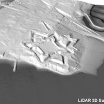
GOLDEN, Colorado, 18 March 2021 – A Canadian archaeologist is using advanced mapping and visualization technologies to bring one of the earliest European settlements in North America back to life. Dr. Jonathan Fowler combined a centuries-old map with a modern 3D terrain model to portray Fort Anne and its surrounding in stunning detail – just as […]
True View 515 Release Webinar
True View 515 3DIS® Release – February 24, 2021 l 10:00 AM CST
Down to Earth – Drone Lidar Surveying Reality Series Returns

Down to Earth – Drone Lidar Surveying Reality Series Returns – “Down to Earth” is a reality series that shows how real surveyors collect data and turn it into real deliverables, despite challenging conditions, rugged terrain and lurking danger.
3D laser scan reveals Christ the Redeemer as you’ve never seen it before

Geospatial mapping specialist GeoSLAM has produced a never-before-seen digital twin of the inside of the world-famous Christ the Redeemer statue before its 90th birthday restoration work begins.
Fugro achieves UK first with RAMMS bathymetric lidar technology

Fugro has won a contract to capture bathymetric lidar of Northern Ireland’s coastline as part of a project from the Department of Agriculture, Environment and Rural Affairs (DAERA) to create a detailed 3D elevation model of the coast. The nearshore survey will acquire satellite-derived bathymetry (SDB) data and, for the first time in the UK, Fugro will use their innovative Rapid Airborne Multibeam Mapping System (RAMMS) to collect lidar bathymetry data.
Velodyne Lidar Signs Multi-Year Sales Agreement with Emesent
Equipped with Velodyne Sensors, Emesent Autonomous Scanning System Makes Data Capture Fast and Simple for Forestry, Infrastructure, Mapping and Film Industries
LiDAR Can Create Richer Contextually-Aware User Experiences, Finds Strategy Analytics
LiDAR has Potential to Help Consumers be More Socially Connected and More Creative in Augmented and Virtual Worlds
World-class Lidar Crowd Analytics Solution Partnership to Transform Smart Spaces With Anonymized Crowd Perception
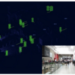
The Indoor Lab partners with Cepton to deliver state-of-the-art space and crowd analytics, with unparalleled social distancing and cleaning metrics