
Ceremony to be held at GeoWeek 2022 in Denver, Colorado
Virtual Surveyor Improves Point Cloud Workflow to Fully Leverage Drone LiDAR Payloads

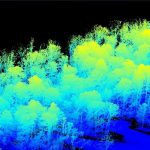
AARSCHOT, Belgium, 7 September 2021 – Virtual Surveyor has developed an enhanced point cloud workflow for Version 8.3 of its drone surveying software that allows users to take full advantage of the new LiDAR payloads like the DJI Zenmuse L1. LiDAR drone sensor systems enable users to capture survey-grade elevation data even in vegetated terrain.
Using UAV LiDAR to obtain and analyse key metrics for operational forest management
This new case study from Routescene demonstrates the value of UAV LiDAR point cloud data for operational forest management. Traditionally gathering metrics and information for forest management has been undertaken using airborne photogrammetry or by manually walking the site. More recently airborne LiDAR has been recognised as a useful tool and now drone derived LiDAR […]
SoCalGas to Use Gas Mapping LiDAR™ to Reduce Methane Emissions
Nation’s Largest Gas Distribution Utility Selects High-Tech Airborne Laser Solution from Bridger Photonics to Track Down Methane Emissions
Velodyne Lidar Announces Multi-Year Sales Agreement with Renu Robotics
Using Velodyne Puck™ Sensors, Renu Robotics Revolutionizing Vegetation Management for Solar Energy Facilities
London Borough of Harrow creates digital twin with new street imagery and LiDAR data
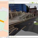
New approach will help improve Planning, Highways and Council Tax operations
RedTail LiDAR Systems Unveils Innovative LiDAR System for Small Drones
Fairmont, WV, August 11, 2021 — RedTail LiDAR Systems, a leader in microelectromechanical systems (MEMS) mirror-based LiDAR technology, today unveiled the market introduction of the RTL-450 LiDAR sensor. The product will be launched at the XPONENTIAL 2021 Trade Show which is being held in Atlanta, Georgia from August 16-19.
Save the Date – Automotive LIDAR 2021, September 21-23, 2021

Automotive LIDAR 2021, coming up on September 21-23, 2021 (http://www.automotivelidar.com). The conference will be fully online again this year.
North Dakota Department of Transportation Selects GeoCue True View LIDAR/Imaging Technology for UAS Program
July 21, 2021 – HUNTSVILLE, AL – North Dakota Department of Transportation recently acquired a GeoCue True View 640 3D Imaging System (3DIS®) for their UAS program. GeoCue’s True View 3D Imaging Sensors allow for both drone LIDAR and imagery to be collected in a single flight on most UAS platforms.
North Dakota Department of Transportation Selects GeoCue True View LIDAR/Imaging Technology for UAS Program
July 21, 2021 – HUNTSVILLE, AL – North Dakota Department of Transportation recently acquired a GeoCue True View 640 3D Imaging System (3DIS®) for their UAS program. GeoCue’s True View 3D Imaging Sensors allow for both drone LIDAR and imagery to be collected in a single flight on most UAS platforms. The simultaneous data collection, […]