Huntsville, AL – Exelon Clearsight, industry-leading robotics inspection company, recently acquired GeoCue Group Inc.’s True View 615 3D Imaging System, adding to their fleet of cutting-edge drone mapping technologies.
Hexagon’s R-evolution expands its sustainability agenda to help protect coastal blue carbon ecosystems
Stockholm, Sweden, 16 December 2021 – Hexagon AB, a global leader in digital reality solutions, today announced R-evolution’s efforts to map the threatened seagrass meadows of the Caribbean islands, beginning with the coastal waters of the Bahamas. In collaboration with Beneath The Waves – a leading, global, non-profit organisation dedicated to protecting marine environments – […]
Parrot ANAFI Ai, the first 4G connected robotic UAV is ready for work.

Parrot ANAFI Ai starts shipping in January.
LiDAR Market to Hit US$ 4.1 Billion Revenue by 2027
The increasing investments and innovations in the field of LiDAR systems are propelling the global LiDAR market growth throughout the forecast period.
Woolpert Augments Fleet with 2nd King Air 300, Globally Expands Aerial Acquisition Capabilities

The AWR-certified turboprop aircraft increases the firm’s ability to support international geospatial projects.
Hexagon announces partnership with Airbus for near real-time airborne bathymetric LiDAR surveillance system
(Jönköping, Sweden, 18 November 2021) Hexagon’s Geosystems division announced today a partnership with Airbus to integrate two Leica Chiroptera 4X bathymetric LiDAR sensors for maritime surveillance into the C295 MSA, Airbus’ Maritime Surveillance Aircraft.
Virtual Surveyor Provides Comprehensive Insights into Drone Survey Data with Addition of Profile View
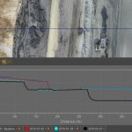
AARSCHOT, Belgium, 17 November 2021 – With the goal of giving surveyors a better understanding of the topographic data captured by drone mapping sensors, Virtual Surveyor has unveiled Profile View functionality in Version 8.4 of its popular surveying software. Profile View enables users to generate an elevation profile simply by drawing an onscreen traverse across any […]
GeoCue Expands True View 3DIS® Line with True View 435

Huntsville, AL – GeoCue is excited to announce that we are, once again, expanding our line of True View 3D imaging sensors (3DIS®). The True View 435 is our next-generation topography/wire grade LIDAR/Imaging sensor. Featuring a 16 beam Hesai PandarXT LIDAR unit, world class Trimble Applanix APX-15 Position/Orientation System (POS) and dual GeoCue mapping cameras, […]
GeoCue Releases True View EVO Embedded Metashape
Huntsville, AL – GeoCue Group Inc. is pleased to announce an embedded version of Agisoft’s Metashape photogrammetric processing software. We have built interfaces directly into our LIDAR/Photogrammetric processing software, True View EVO, for driving both an embedded version of Metashape (Metashape for EVO, MfE) as well as the full GUI version of Metashape Professional. This […]
Using drone LiDAR to improve powerline vegetation management
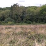
The latest in the series of forestry based case studies from Routescene demonstrates the value of remote sensing techniques such as UAV LiDAR for identifying diseased or damaged trees and overgrown vegetation close to powerlines to prevent outages or forest fires.