GIS user technology news

News, Business, AI, Technology, IOS, Android, Google, Mobile, GIS, Crypto Currency, Economics

  • Advertising & Sponsored Posts
    • Advertising & Sponsored Posts
    • Submit Press
  • PRESS
    • Submit PR
    • Top Press
    • Business
    • Software
    • Hardware
    • UAV News
    • Mobile Technology
  • FEATURES
    • Around the Web
    • Social Media Features
    • EXPERTS & Guests
    • Tips
    • Infographics
  • Blog
  • Events
  • Shop
  • Tradepubs
  • CAREERS
You are here: Home / Archives for * PRESS / Earth Imaging - Remote Sensing

Imagery, earth imaging and remote sensing

Swiss drone specialist partners with GeoSLAM to power latest release, Elios 3

May 31, 2022 By GISuser

The launch of the Elios 3, created by Swiss indoor drone specialists, Flyability, marks a major new partnership with GeoSLAM.

Filed Under: Earth Imaging - Remote Sensing, LiDAR, Top Press Tagged With: geoslam, lidar

Geospatial hardware company – Mosaic – officially announces the launch of their next mobile mapping camera

May 25, 2022 By GISuser

Prague, Czech Republic, May 25, 2022 – New mobile mapping camera hits the market

Filed Under: Business, Earth Imaging - Remote Sensing, Hardware Tagged With: Camera, imaging

NOAA predicts above-normal 2022 Atlantic Hurricane Season

May 24, 2022 By GISuser

Ongoing La Niña, above-average Atlantic temperatures set the stage for busy season ahead

Filed Under: Earth Imaging - Remote Sensing, Environment, Research, Top Text Lead Story Tagged With: hurricane, NOAA

Woolpert Selected by Pacific Community (SPC) for Topo-Bathy Lidar, Aerial Imagery in Vanuatu

May 24, 2022 By GISuser

The data and imagery will enable the island nation and SPC to mitigate risk and improve disaster resilience.

The data and imagery will enable the island nation and SPC to mitigate risk and improve disaster resilience.

Filed Under: Business, Earth Imaging - Remote Sensing Tagged With: Woolpert

Phase One Announces Next-Generation Aerial Solutions Enhanced with Near Infrared Capabilities

May 18, 2022 By GISuser

Ideal for Agriculture, Environment, Land Management

Filed Under: Business, Earth Imaging - Remote Sensing Tagged With: aerial mapping

BlackSky Upgrades Customers’ Site Monitoring Experience with Enhanced Analytics and Imaging Capabilities

April 26, 2022 By GISuser

New features give users the ability to extract additional intelligence over sites of economic interest worldwide

Filed Under: Business, Earth Imaging - Remote Sensing Tagged With: blacksky, GeoINT, Imagery

Maxar satellite imagery: Second cemetery in Mariupol area identified with new excavations

April 23, 2022 By GISuser

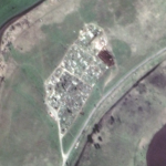
Recent Maxar high-resolution satellite imagery of the Mariupol area reveals the existence of a second cemetery that has expanded over the past month and includes several long trenches that are/will likely become new grave sites.

Filed Under: Earth Imaging - Remote Sensing, Top Press Tagged With: Satellite Imagery, Ukraine

TCarta to Showcase Satellite-Derived Bathymetric Products on Absolute Ocean Platform at GEOINT 2022

April 13, 2022 By GISuser

https://gisuser.com/wp-content/uploads/2022/04/TCarta-GEOINT-Image.jpg

Presentations Include Trident Tools, ICESat-2 Data 

Filed Under: Business, Earth Imaging - Remote Sensing, LiDAR, Top Press Tagged With: TCarta

Descartes Labs Government to Present in GEOINT Tradecraft Competition and Host Two Workshops on Autonomous Target Sensing Using ALL-INT Data Fusion at GEOINT 2022

April 12, 2022 By GISuser

SANTA FE, New Mexico, 11 April 2022 – Descartes Labs Inc., a leading solutions provider of geospatial intelligence originating out of Los Alamos National Laboratory, government subsidiary, Descartes Labs Government, Inc., will present in the GEOINT Tradecraft Competition and host a two-part training workshop at GEOINT 2022 in Colorado.

Filed Under: Business, Earth Imaging - Remote Sensing

Phase One to Showcase iXM-GS120 Wide-Area Aerial Camera at GEOINT 2022 in Colorado

April 11, 2022 By GISuser

Designed for Manned & Unmanned Aircraft

Filed Under: Earth Imaging - Remote Sensing, Hardware, Top Press Tagged With: Aerial Camera, GeoINT, Phase One

« Previous Page
Next Page »

Recent Industry News

Top Benefits of AI Video Surveillance for Businesses and Public Spaces

June 5, 2026 By GISuser

How to Choose the Best Office Interior Designers in Delhi for End-to-End Projects

June 3, 2026 By GISuser

Why Bathroom Renovation Services Often Change More Than Just the Bathroom

May 20, 2026 By GISuser

The Drift Between Early Notes and Final Case Files in Abuse-Related Legal Support

April 29, 2026 By GISuser

Hot News

State of Data Science Report – AI and Open Source at Work

HERE and AWS Collaborate on New HERE AI Mapping Solutions

Virtual Surveyor Adds Productivity Tools to Mid-Level Smart Drone Surveying Software Plan

Categories

Copyright gletham Communications 2015 - 2026

Go to mobile version