GIS user technology news

News, Business, AI, Technology, IOS, Android, Google, Mobile, GIS, Crypto Currency, Economics

  • Advertising & Sponsored Posts
    • Advertising & Sponsored Posts
    • Submit Press
  • PRESS
    • Submit PR
    • Top Press
    • Business
    • Software
    • Hardware
    • UAV News
    • Mobile Technology
  • FEATURES
    • Around the Web
    • Social Media Features
    • EXPERTS & Guests
    • Tips
    • Infographics
  • Blog
  • Events
  • Shop
  • Tradepubs
  • CAREERS
You are here: Home / Archives for * PRESS / Earth Imaging - Remote Sensing

Imagery, earth imaging and remote sensing

Launch of the second SpaceDataHighway satellite @AirbusSpace

May 6, 2019 By GISuser

6 May 2019 – The EDRS-C satellite, the second node of the SpaceDataHighway network (also known as EDRS), will be launched into geostationary orbit at 31° East on 24 July 2019 by an Ariane 5 launcher. Once positioned above Europe, it will provide redundant back-up for the SpaceDataHighway system, double transmission capacity and be able to relay the data from two observation satellites simultaneously.

Filed Under: Earth Imaging - Remote Sensing

Maxar Technologies collected new satellite imagery of Davenport, Iowa flooding caused by the Mississippi River

May 6, 2019 By GISuser

Maxar Technologies collected new satellite imagery yesterday, May 4, 2019, of Davenport, Iowa and the downtown flooding caused by the Mississippi River

Filed Under: Business, Earth Imaging - Remote Sensing Tagged With: flood, Imagery

Galileo (GNSS) starts High Accuracy Service in 2019

May 3, 2019 By GISuser

The launches of the last four of a total of thirty Galileo satellites are scheduled for the end of 2020. The system is already in operation, and this year the construction of the High-Accuracy service is due to start. This service will enable more precise position determination around the globe.

Filed Under: Earth Imaging - Remote Sensing

Satellite Imagery: Before/After of Notre Dame Cathedral Fire

April 18, 2019 By Editor

Notre Dame Cathedral_Before Fire_17April2019

On April 17,  Maxar Technologies collected a new WorldView-2 satellite image of the Notre Dame Cathedral in Paris that clearly shows the aftermath of the recent fire.

Filed Under: Earth Imaging - Remote Sensing, Top Press Tagged With: Imagery, notre dame

SimActive Software Used with eBee X for Shoreline Mapping

April 9, 2019 By GISuser

SimActive Software Used with eBee X for Shoreline Mapping

Montreal, Canada, April 9th, 2019 – SimActive Inc., a world-leading developer of photogrammetry software, announces that Correlator3D™ is being used for mapping projects in Brittany, France by Altimedias.  An eBee X equipped with senseFly S.O.D.A. 3D camera is flown along the shoreline to produce high-resolution true orthomosaics and 3D models.

Filed Under: Earth Imaging - Remote Sensing, Environment Tagged With: SimActive

Copernicus Masters 2019 Submissions Open

April 3, 2019 By GISuser

Sustainable Development with the Copernicus programme

Filed Under: Developer, Earth Imaging - Remote Sensing, Top Press Tagged With: Copernicus

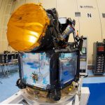
Airbus prepares Cheops satellite for launch – @AirbusSpace @esa @CDTIoficial #Cheops #exoplanets
March 29, 2019 By GISuser

Airbus prepares Cheops satellite for launch

Final technical review successfully passed 

Filed Under: Earth Imaging - Remote Sensing

Microsoft releasing more than 12 million building footprints in Canada to the OpenStreetMap community.

March 20, 2019 By GISuser

Microsoft launches Building Footprints in Canada

By Jason Hermitage – GM Public Sector, Microsoft Canada – Digital transformation is providing organizations with not only information that was never thought possible, but information that is accessible and usable. Data is the foundational resource that allows organizations to transform and uncover the insights they need to make smart decisions.

Filed Under: Around the Web, Earth Imaging - Remote Sensing, Top Text Lead Story Tagged With: Microsoft launches Building Footprints in Canada

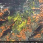
DigitalGlobe Shares Satellite Imagery of California Superbloom
March 20, 2019 By GISuser

DigitalGlobe Satellite Imagery: California Superbloom

DigitalGlobe collected a new set of images yesterday (March 19th) of the “Superbloom” near Lake Elsinore, California. The colorful satellite imagery shows the hillsides along Walker Canyon filled with blooming poppies as well as hundreds of cars parked nearby and people hiking along trails in the area.

Filed Under: Earth Imaging - Remote Sensing, Top Text Lead Story Tagged With: California Superbloom, DigitalGlobe, Imagery, wildfire

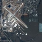
DigitalGlobe Satellite Imagery: Flooding in U.S. Midwest
March 19, 2019 By GISuser

DigitalGlobe’s WorldView-2 satellite collected new imagery March 18, 2019 of the historic flooding of the Missouri and Platte rivers south of Omaha, Nebraska.

Filed Under: Earth Imaging - Remote Sensing, Emergency Response Tagged With: DigitalGlobe, flood

« Previous Page
Next Page »

Top Press

The Global Expansion of Aueshah: A New Era of High Jewelry

April 11, 2026 By GISuser

KARACHI, PAKISTAN. The international luxury market is experiencing a profound shift. Consumers are increasingly rejecting mass-produced goods in favor of rarity, authenticity, and emotional depth. … [Read More...]

State of Data Science Report – AI and Open Source at Work

September 10, 2025 By GISuser

AI and Open Source at Work … [Read More...]

Topcon Announces Landmark Expansion of Topnet Live Network Across USA

January 26, 2025 By GISuser

LIVERMORE, Calif.---Topcon Positioning Systems has announced a significant expansion of its Topnet Live reference station network, introducing 200 new geodetic stations strategically positioned across … [Read More...]

Space Flight Laboratory (SFL) Announces Launch and Deployment of NorSat-4 Maritime Monitoring Microsatellite

January 19, 2025 By GISuser

Seventh Satellite Developed by SFL for Norway … [Read More...]

HERE and BMW Group extend partnership on AI-powered mapping system

January 8, 2025 By GISuser

HERE and BMW Group extend partnership on AI-powered mapping system for automated driving and enhanced road safety … [Read More...]

Everest Base Camp Helicopter Tour, Helicopter Return Trek, and Manaslu Circuit Trek: Which Nepal Adventure Is Right for You?

November 6, 2026 By GISuser

Almost everyone planning a Nepal trip runs into the same wall. You want the big mountains, you have a fixed number of days, and every itinerary you read seems to promise something … [Read More...]

SFL Missions Inc. Confirms Successful Deployment of Six HawkEye 360 Radio Frequency Detection Satellites with Advanced Capabilities

October 27, 2026 By GISuser

MĀHIA, New Zealand, 26 October 2026 – SFL Missions Inc. today confirmed the successful deployment of six radio frequency (RF) detection and geolocation satellites for HawkEye 360 … [Read More...]

Canadian-Built RoadEng 12 Uses AI to Find the Best Location for New Resource and Rural Roads

October 17, 2026 By GISuser

Vancouver, BC, Canada, October 15, 2026 – North Vancouver-based Softree Technical Systems today released RoadEng Version 12, used in more than 75 countries to locate and design … [Read More...]

Beyond the Map: How AI Image and Video Generation Is Changing Geospatial Communication

October 14, 2026 By GISuser

Ask anyone who has shipped a GIS project what the hardest part was, and the answer is rarely the spatial analysis. It is almost always the communication. A site suitability … [Read More...]

From Maternity to Everyday Wear: Building a Wardrobe That Grows With You

October 14, 2026 By GISuser

When I think about maternity clothing, I feel the biggest mistake is buying too many things at once. During pregnancy, your body keeps changing, and something that fits well today … [Read More...]

Copyright gletham Communications 2015 - 2026

Go to mobile version