GIS user technology news

News, Business, AI, Technology, IOS, Android, Google, Mobile, GIS, Crypto Currency, Economics

  • Advertising & Sponsored Posts
    • Advertising & Sponsored Posts
    • Submit Press
  • PRESS
    • Submit PR
    • Top Press
    • Business
    • Software
    • Hardware
    • UAV News
    • Mobile Technology
  • FEATURES
    • Around the Web
    • Social Media Features
    • EXPERTS & Guests
    • Tips
    • Infographics
  • Blog
  • Events
  • Shop
  • Tradepubs
  • CAREERS
You are here: Home / Archives for Copernicus

Copernicus Masters 2020 Submissions Open 1 April

April 1, 2020 By GISuser

Copernicus Masters 2020 Submissions Open 1 April

The temperature is rising – hottest winter by far

Filed Under: Business, Developer, Earth Imaging - Remote Sensing Tagged With: Copernicus

The new Copernicus Land product on Coastal Zones in Europe

September 25, 2019 By GISuser

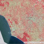
European Environment Agency awards 3 million Euro contract to Planetek Italia for the new Copernicus Land product on Coastal Zones.

Filed Under: DATA Tagged With: Copernicus

Copernicus Masters 2019 Submissions Open

April 3, 2019 By GISuser

Sustainable Development with the Copernicus programme

Filed Under: Developer, Earth Imaging - Remote Sensing, Top Press Tagged With: Copernicus

An Eye on Earth: Combined Data Use in New Business Models

June 13, 2016 By Editor

The Sentinel satellite constellation and the ground stations of Europe’s Copernicus programme deliver huge amounts of data on our planet every single day. In addition to supporting long-term studies of climates and environments, they provide rapid access to aerial overviews in the event of sudden floods, forest fires, and other natural disasters.

Filed Under: Business, Earth Imaging - Remote Sensing Tagged With: Copernicus, Eye on Earth

ESA and Airbus Defence and Space sign contract for new Copernicus Earth observation mission

May 11, 2015 By GISuser

At the 36th International Symposium on Remote Sensing of Environment in Berlin, the European Space Agency (ESA) and Airbus Defence and Space, the world’s second largest space company, signed the development and production contract for the Jason-CS/Sentinel-6A satellite. Jason-CS/Sentinel-6 is a mission to carry out high-precision measurements of ocean surface topography. The contract is worth 177 million euros. The […]

Filed Under: Earth Imaging - Remote Sensing Tagged With: Airbus Defence, Copernicus

GAF and ESA sign an agreement regarding the delivery of IRS data for the Copernicus Data Warehouse 2014-2020

May 8, 2015 By GISuser

GAF AG, the exclusive supplier of optical Indian Remote Sensing data in Europe, has signed an agreement with ESA concerning the provision of IRS data for the Copernicus Data Warehouse. The agreement will run until the end of 2020.

Filed Under: Earth Imaging - Remote Sensing Tagged With: Copernicus

Sentinel-2A: New eyes of Copernicus ready for space

February 24, 2015 By GISuser

After six months of intensive testing, the first Sentinel-2 satellite developed and built by Airbus Defence and Space for the European Space Agency (ESA) is getting ready for its mission in space.

Filed Under: Earth Imaging - Remote Sensing, Top Press Tagged With: Copernicus

Recent Industry News

Best Equipment Labels for Industrial Use: Ranked Systems That Survive Real-World Conditions

April 17, 2026 By GISuser

Building a Global Natural Brand: The Digital Journey of VedaOils

April 15, 2026 By GISuser

DeltaQuad partners with Meridein Group OÜ to strengthen UAS capability in the Baltics

April 15, 2026 By GISuser

The Complete Guide to Improving Home Safety and Efficiency with Dryer Vent Cleaning

April 12, 2026 By GISuser

Hot News

State of Data Science Report – AI and Open Source at Work

HERE and AWS Collaborate on New HERE AI Mapping Solutions

Virtual Surveyor Adds Productivity Tools to Mid-Level Smart Drone Surveying Software Plan

Categories

Copyright gletham Communications 2015 - 2026

Go to mobile version