GISuser.com

GIS and Technology news for mapping professionals

  • PRESS
    • Submit PR
    • Top Press
    • Business
    • Software
    • Hardware
    • UAV News
    • Mobile Technology
  • FEATURES
    • Around the Web
    • Social Media Features
    • EXPERTS & Guests
    • Tips
    • Infographics
  • Events
  • CAREERS
  • Advertise
    • Advertise
  • Blog
  • Shop
  • Tradepubs
You are here: Home / * PRESS / Earth Imaging - Remote Sensing / DigitalGlobe Shares Satellite Imagery of California Superbloom

DigitalGlobe Shares Satellite Imagery of California Superbloom

March 20, 2019 By GISuser

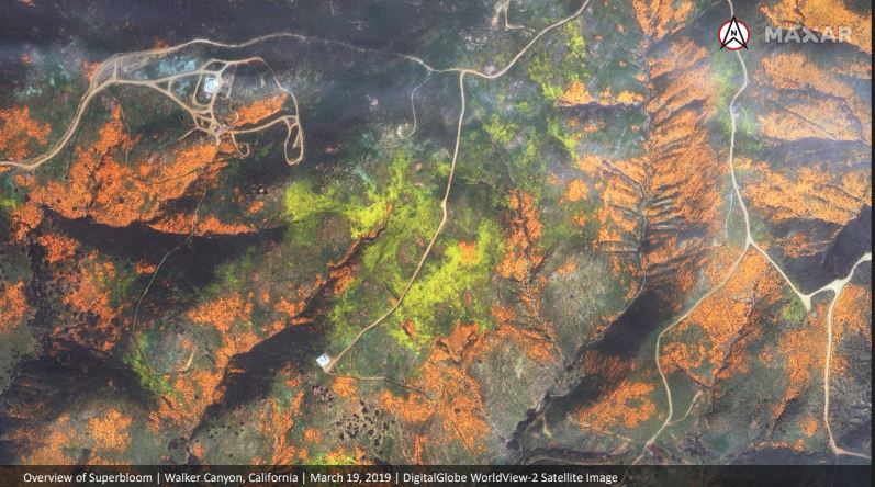
DigitalGlobe collected a new set of images yesterday (March 19th) of the “Superbloom” near Lake Elsinore, California. The colorful satellite imagery shows the hillsides along Walker Canyon filled with blooming poppies as well as hundreds of cars parked nearby and people hiking along trails in the area.

DigitalGlobe Satellite Imagery: California Superbloom

DigitalGlobe Satellite Imagery: California Superbloom

DigitalGlobe Satellite Imagery: California Superbloom

Satellite image ©2019 DigitalGlobe, a Maxar company.

Related Articles on GISuser:

  • Maxar Satellite Imagery: Dixie Fire, CaliforniaMaxar Satellite Imagery: Dixie Fire, California
  • Satellite Imagery @Maxar : Southern California’s Blue Ridge and Silverado WildfiresSatellite Imagery @Maxar : Southern California’s Blue Ridge and Silverado Wildfires
  • Satellite Imagery: East Troublesome Wildfire Near Rocky Mountain National Park, ColoradoSatellite Imagery: East Troublesome Wildfire Near Rocky Mountain National Park, Colorado
  • Satellite Imagery: August Complex Fires, CaliforniaSatellite Imagery: August Complex Fires, California
  • Maxar Satellite Imagery: Phoenix and Talent Oregon WildfiresMaxar Satellite Imagery: Phoenix and Talent Oregon Wildfires
  • Satellite Imagery via Maxar : Cameron Peak Wildfire, ColoradoSatellite Imagery via Maxar : Cameron Peak Wildfire, Colorado

Filed Under: Earth Imaging - Remote Sensing, Top Text Lead Story Tagged With: California Superbloom, DigitalGlobe, Imagery, wildfire


Editor’s Picks

Keep the UAV Devices Away – Create and Register Your Own No Fly Zone

Prestigious Award Win For Local Crowd Funded Start Up Business

Data Tip – Customized Coverage from LandScan Global Population Database

Opportunity – Promote your Company’s ESRIUC Week Activities with GISuser

See More Editor's Picks...

Feed

  • RSS


GIS jobs


Recent Features

Digitalization and Simulation at the North Pole

Natural Gas District & GIS-Centric Asset Management

5 Ways Technology Is Affecting The Sharing Economy

Spotlight – Township Canada: Explore Canadian Legal Land Descriptions on a Map

GeoGeeksinCars – The one in “Tippy” the right-hand drive Mitsubishi, at DevSummit

More Posts from this Category

Categories

Recent Posts

  • The ICC Cricket World Cup Betting – Facts and Betting Tips
  • Blog Title: How eGov Platform Automating Citizen Services
  • A treadmill is one of the most popular fitness equipment
  • 3 Things to Help You Become a Software Engineer
  • Esri Announces Winners of the 2022 ArcGIS Online Competition

RSS Career Tips

  • Four Characteristics of the Best Virtual Employees
  • 8 Questions Employers Should Ask About Coronavirus
  • Jobcase Launches Free Unemployment Resource Center for Workers Impacted by COVID-19
  • Must-Have Gadgets and Technology for the Remote Office Worker
  • Must-Have Gadgets and Technology for the Remote Office Worker


shop for geogeek swag

RSS Tech pubs

  • Top Tips and Tricks: Windows 11
  • The 2022 State of the Data Center Report
  • What is Network Security?

RSS Computers

  • The Essentials of Information Security Kit: Includes a Free PC Security Handbook - 2nd Edition eBook
  • The Idiot's Ultimate Guide to Build Your Own PC
  • Windows... On Speed

RSS HR Tips

  • Measuring and Managing Employee Experience
  • At Work: The 2022 Workplace Trends Report
  • The 2022 Guide To Creating A Great Visitor Experience

RSS Gov Tech

  • The Bipartisan Infrastructure Bill: How you can win more bids
  • How Connected Vehicle Data Can Transform Public Sector Decision-Making
  • Getting started with personalization at scale

RSS UAV news

  • Draganfly Deploys Versatile Situational Assessment Drones to Ukraine
  • Ocean Specialists Inc. Launches “USVs as a Service” Business Line
  • UAS Drone Subsidiary, Duke Robotics’, Sniper Drone showcased at a leading International Airshow in the Asia Pacific Region

RSS Geojobs

  • IT Endpoint Lead
Copyright Spatial Media LLC 2003 - 2015