GIS user technology news

News, Business, AI, Technology, IOS, Android, Google, Mobile, GIS, Crypto Currency, Economics

  • Advertising & Sponsored Posts
    • Advertising & Sponsored Posts
    • Submit Press
  • PRESS
    • Submit PR
    • Top Press
    • Business
    • Software
    • Hardware
    • UAV News
    • Mobile Technology
  • FEATURES
    • Around the Web
    • Social Media Features
    • EXPERTS & Guests
    • Tips
    • Infographics
  • Around the Web
  • Events
  • Shop
  • Tradepubs
  • CAREERS
You are here: Home / Archives for * PRESS / Emergency Response

Duke Energy crews begin power restoration following Hurricane Debby

August 5, 2024 By GISuser

3,000 workers are responding to power outages as weather conditions allow; nearly 171,000 restored so far

Filed Under: Emergency Response Tagged With: begin, crews, debby, duke, emergency, energy, following, hurricane, Power, response, restoration

Northern Ireland Fire & Rescue Service awards contract to Cadcorp

January 25, 2023 By GISuser

National fire service selects workload modelling and risk modelling software from Cadcorp

Filed Under: Business, Emergency Response Tagged With: Cadcorp, emergency, Fire

NGA deploys to assist Hurricane Ian search and rescue efforts

October 4, 2022 By GISuser

NGA deploys to assist Hurricane Ian search and rescue efforts

SPRINGFIELD, Virginia – The National Geospatial-Intelligence Agency is providing geospatial intelligence support to the combined search and rescue efforts in the aftermath of Hurricane Ian from the headquarters of Florida Task Force 1 in Fort Myers, Florida.

Filed Under: Emergency Response, Top Text Lead Story Tagged With: hurricane, NGA

Betterview Provides Property-Level Analytics for Fast, Accurate Catastrophe Events Response

July 7, 2022 By GISuser

SAN FRANCISCO, July 07, 2022 (GLOBE NEWSWIRE) — Betterview, an InsurTech provider of actionable property intelligence to property and casualty (P&C) insurance companies, is pleased to announce the launch of the company’s new Catastrophe Response System (CAT-RS) which solves many of the greatest challenges insurers face when responding to natural catastrophe (CAT) events such as hurricanes, […]

Filed Under: Business, Emergency Response Tagged With: Emergency Response

L3Harris High-Resolution Weather Instrument Set to Launch March 1 on NOAA’s GOES-T Satellite

February 23, 2022 By GISuser

Atmospheric river flowing across the northern Pacific Ocean captured by L3Harris’ Advanced Baseline Imager onboard the GOES-West satellite. Credit: CIRA/NOAA

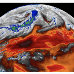
MELBOURNE, Fla.–L3Harris Technologies’ (NYSE:LHX) third high-resolution weather instrument is set to launch March 1 onboard a NOAA satellite – strengthening the nation’s ability to monitor the environment and rapidly detect severe weather.

Filed Under: Earth Imaging - Remote Sensing, Emergency Response Tagged With: NOAA

Maxar Satellite Imagery: Flooding Along Fraser River, British Columbia

November 23, 2021 By GISuser

Maxar collected new satellite imagery on Friday (November 19th) of the ongoing flooding in Sumas Prairie to the east of Abbotsford, British Columbia, Canada. Highways, roads and many buildings and farms remain under water.

Filed Under: Earth Imaging - Remote Sensing, Emergency Response, Top Text Lead Story Tagged With: flood, Imagery, maxar

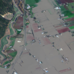
Maxar Satellite Imagery: Flooding in New Jersey

September 4, 2021 By GISuser

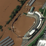
Maxar collected new high resolution satellite imagery yesterday (September 2nd at 11:52 AM, Eastern) that shows historic flooding along the Raritan River in New Jersey. As the remnants of Hurricane Ida moved through the northeast of the United States, the storm dropped record-breaking rainfall causing floods and damage in multiple towns and communities including Somerville, Manville, […]

Filed Under: Earth Imaging - Remote Sensing, Emergency Response, Environment, Top Press Tagged With: flood, hurricane, maxar, New Jersey

Maxar Satellite Imagery: Hurricane Ida Damage, Louisiana

September 2, 2021 By GISuser

Maxar’s satellites collected an extensive amount of new imagery on August 31st over the Gulf Coast and southern Louisiana that help to convey some of the damage caused by Hurricane Ida.

Filed Under: Earth Imaging - Remote Sensing, Emergency Response, Top Press Tagged With: hurricane, Imagery, maxar

AccuWeather to Keep T-Mobile Customers Ahead of Severe Weather with Exclusive Up to the Minute® Alerts

September 2, 2021 By GISuser

Superior Accuracy™ and timely alerts help keep T-Mobile customers safer  throughout this year’s hurricane season and beyond

Filed Under: Business, Emergency Response, Mobile Tagged With: Emergency Response, Weather

Maxar Satellite Imagery: Caldor Fire Approaching Lake Tahoe

September 1, 2021 By GISuser

Maxar continues to monitor the Caldor wildfire as it approaches the southern edge of Lake Tahoe along the California-Nevada border.  Maxar collected yesterday (August 31st) that shows closer views of South Lake Tahoe, the active fire lines and a large pyrocumulus cloud formed by the intense fire.

Filed Under: Earth Imaging - Remote Sensing, Emergency Response, Top Press Tagged With: California, maxar, wildfire

Next Page »

Recent Posts

  • The Hidden Shield: How Invisible Watermarking Protects Digital Content
  • Dual Diagnosis: Why Treating Co-Occurring Mental Health and Addiction Together Is Essential for Recovery
  • Why Search Engine Optimisation Is Essential For Modern Digital Marketing
  • How to Find Safe, Affordable Access to GLP-1 Medications in 2025
  • Powerful Bonus Features Supporting Steady Progress Throughout Engaging Casino Play
  • The Power of Analytics: Turning Consumer Insights into Action
  • Cost Distribution of Hiring a Moving Company in Dubai
  • Oxyhydrogen Brazing in HVAC Systems: Fast, Clean, and Precise Copper Tube Connections
  • Moto G 5G Screen Replacement Cost: Complete Guide
  • When Local Cravings Meet Instant Convenience

Recent Features

Space Flight Laboratory (SFL) Announces Successful Launch & Deployment of HawkEye 360’s Cluster 11

FOSS4G NA 2024: The Premier Open Source Geospatial Conference Returns to St. Louis, September 9-11

Photographer Touch Reveal the Top Cameras, Lenses, and Photo Editing Tools of 2022

Digitalization and Simulation at the North Pole

Natural Gas District & GIS-Centric Asset Management

More Posts from this Category

Categories

RSS Career Tips

  • Four Characteristics of the Best Virtual Employees
  • 28 Tools to Conquer the Social Media Recruiting World
  • 8 Questions Employers Should Ask About Coronavirus
  • Jobcase Launches Free Unemployment Resource Center for Workers Impacted by COVID-19
  • Must-Have Gadgets and Technology for the Remote Office Worker


featured podcast

RSS Tech pubs

  • Breaking Silos and Building the Grid of the Future
  • From Risk to Readiness: How to Plan Around Interconnection Uncertainty
  • Data Center Location Strategy

RSS Computers

  • How the Cloud is Reshaping Virtual Desktops
  • Millennials as Brand Advocates - New Research Study Results
  • Vehicles Best Practices Installation Guide

RSS HR Tips

  • AWS GovCloud (US) Celebrates 10th Anniversary and a Decade of Digital Transformation in the Federal Government
  • Exploring the Impact of COVID-19 on Customer Behavior
  • The Pivot to 100% Remote Training in the Contact Center

RSS Gov Tech

  • 10 Legal Jobs You Can Get Without a Law Degree
  • J.D. Power Examines How the Inflation Reduction Act Reshapes EV Landscape
  • Making Telehealth Work for You: The Ultimate Guide

Copyright Spatial Media LLC 2003 - 2015

Go to mobile version