SPRINGFIELD, Virginia – The National Geospatial-Intelligence Agency is providing geospatial intelligence support to the combined search and rescue efforts in the aftermath of Hurricane Ian from the headquarters of Florida Task Force 1 in Fort Myers, Florida.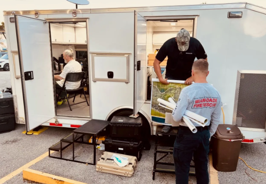
FEMA requested NGA’s expertise early in the response. NGA immediately deployed a team with a self-contained Mobile GEOINT Support Trailer to the hardest hit region of Florida and established a cell of analysts for reach-back support from Springfield, Virginia and St. Louis, Missouri.
“This is a total team effort. It’s important for NGA to be on the ground with FEMA. This lets us provide geospatial support that helps them plan, sequence and prioritize search and rescue efforts in real-time,” said Amanda Cashwell, NGA’s Expeditionary Operations director.
NGA’s onsite team continues to assist urban search and rescue efforts in Fort Myers and the surrounding area, including processing 60,000 unmanned aircraft system images a day and producing graphics for real-time support to ongoing life-saving missions. In addition to NGA’s field team, NGA’s reach-back team is contributing to damage assessments needed to guide food and water distribution and determine evacuation routes, among other relief efforts.
NGA is closely monitoring the situation and has deployed additional personnel and equipment since Sept. 29 based on requests from FEMA and the demand for GEOINT products and services. A second MGST arrived in Fort Myers Oct. 3.
NGA has a long history of providing geospatial intelligence to HADR efforts, dating back to Hurricane Katrina, including support to search and rescue efforts for hurricanes, wildfires and earthquakes.
“Safety-of-life and our homeland defense missions remain top priorities for NGA. We are making equipment and expertise available to support FEMA when and where they request it,” said Vice Adm. Frank Whitworth, director of NGA.
# # #
About NGA
NGA delivers world-class geospatial intelligence that provides a decisive advantage to policymakers, warfighters, intelligence professionals and first responders.
NGA is a unique combination of intelligence agency and combat support agency. It is the world leader in timely, relevant, accurate and actionable geospatial intelligence. NGA enables the U.S. intelligence community and the Department of Defense to fulfill the president’s national security priorities to protect the nation.
During federally-declared emergencies, NGA is authorized under Title 50, Section 3045 authorities to conduct domestic operations when requested by the organization leading the response.
For more information about NGA, visit us online at www.nga.mil, on Instagram, LinkedIn, Facebook and Twitter.