PDFs are famous for being clunky and having an outdated appearance. It takes forever to scroll down, they lack good design, and you have to strain your eyes to read the minor characters on your smartphone’s tiny screen. They are often handled (or mistreated) as raw pre-print files. With a PDF Editor like the one offered […]
E-Book – Mastering Python – Second Edition, Free for a Limited Time

If you are a Python programmer wanting to improve your code quality and readability, this Python book will make you confident in writing high-quality scripts and taking on bigger challenge
TOPODRONE advances airborne bathymetric surveying with AQUAMAPPER launch at INTERGEO 2022

October 18, 2022 – Montreux, Switzerland – TOPODRONE, a Swiss based designer and manufacturer of high-precision LiDAR equipment for installation on drones, vehicles and backpacks, launches AQUAMAPPER, a UAV-based solution for bathymetric surveying and marine construction. The new multitasking data collecting device and TOPODRONE LiDAR ULTRA equipment have been successfully used together for airborne surveying […]
Teledyne announces new Ladybug6 cameras for high accuracy 360-degree spherical image capture

Richmond, CANADA ─ October 17, 2022 ─ Teledyne FLIR Integrated Imaging Solutions is pleased to announce the all new Ladybug6— the latest addition to its field proven Ladybug series. Ladybug6 is the leading high-resolution camera designed to capture 360-degree spherical images from moving platforms in all-weather conditions. Its industrial grade design and out-of-the-box factory calibration produces 72 […]
New solution from Teledyne Geospatial delivers survey-grade lidar point clouds from UAV platforms

Optech CLS-A delivers the precision and accuracy required for survey-grade applications
Mosaic Announces Integration of High Resolution 360º Camera with Laser Scanning Solutions

October 10, 2022 – Ready for release – Mosaic X high resolution cameras, enabling customers to gather more valuable data with their mobile mapping solutions, now compatible with RIEGL’s line of Mobile Laser Scanning Systems.
NGA deploys to assist Hurricane Ian search and rescue efforts
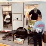
SPRINGFIELD, Virginia – The National Geospatial-Intelligence Agency is providing geospatial intelligence support to the combined search and rescue efforts in the aftermath of Hurricane Ian from the headquarters of Florida Task Force 1 in Fort Myers, Florida.
Fugro and RapidSOS improve emergency response with 3D mapping technology
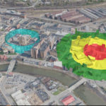
Fugro has partnered with RapidSOS in the US to deliver emergency dispatchers and first responders the dynamic, location-based information needed to speed incident response and improve situational awareness. The solution integrates a patent pending version of the company’s Fugro SIMmetryTM 3D mapping and visualisation technology within RapidSOS’s intelligent safety platform. The RapidSOS partnership enables Fugro […]
Esri Partners with Federal Government and State of California to Tackle Climate Change, Improve Resilience

Map-Based Dashboards Help Communities Assess Exposure to Climate Hazards and Conservation Opportunities
Commercial UAV Expo 2022 Surpasses All Prior Records with 232 Exhibitors and 4,100 Registrants

Commercial drone event featured sold out exhibit hall floor and largest attendee base ever