GIS user technology news

News, Business, AI, Technology, IOS, Android, Google, Mobile, GIS, Crypto Currency, Economics

  • Advertising & Sponsored Posts
    • Advertising & Sponsored Posts
    • Submit Press
  • PRESS
    • Submit PR
    • Top Press
    • Business
    • Software
    • Hardware
    • UAV News
    • Mobile Technology
  • FEATURES
    • Around the Web
    • Social Media Features
    • EXPERTS & Guests
    • Tips
    • Infographics
  • Blog
  • Events
  • Shop
  • Tradepubs
  • CAREERS
You are here: Home / Archives for Portland

From Volcanoes to Vineyards – New Geologic Map Reveals Portland’s Deep History

October 11, 2020 By Editor

Portland Geologic Map

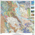
A new digital geologic map of the greater Portland-Vancouver-Hillsboro metropolitan area of Oregon and Washington being released today will support emergency response, conservation, agriculture and recreation.

Filed Under: Environment, Featured TOP PR, Maps and Cartography Tagged With: geology, Portland, USGS

Portland’s official city bike map – digital and interactive, created with ArcGIS WebAppbuilder

August 11, 2017 By GISuser

Portland’s official city bike map

For the first time ever the City of Portland’s official bike map is available in an interactive online version.

Filed Under: Business, Software Tagged With: bike map, Portland

Call for Proposals – FOSS4G 2014, Portland, Oregon

February 12, 2014 By Editor

  FOSS4G (Free and Open Source Software for Geospatial) is pleased to invite proposals for workshops, papers, and presentations for its 2014 conference to be held in Portland, Oregon, USA from September 8th to 13th. The annual FOSS4G conference is the largest global gathering for all those currently or potentially working with open source geospatial […]

Filed Under: GIS Education / Events Tagged With: Call for Proposals - FOSS4G 2014, GIS Education / Events, News, Oregon, Portland

Recent Industry News

The Drift Between Early Notes and Final Case Files in Abuse-Related Legal Support

April 29, 2026 By GISuser

Aerial Surveys Int’l and Global Marketing Insights to Present GEOINT 2026 Workshop on Multi-Domain Geospatial Fusion for Automated Infrastructure Monitoring

April 24, 2026 By GISuser

Why Timing Matters More Than You Think With Spray Seal (And Why People Often Get It Slightly Wrong)

April 22, 2026 By GISuser

The Quiet Planning Stage Most People Don’t See When Building a Pool in Brisbane

April 22, 2026 By GISuser

Hot News

State of Data Science Report – AI and Open Source at Work

HERE and AWS Collaborate on New HERE AI Mapping Solutions

Virtual Surveyor Adds Productivity Tools to Mid-Level Smart Drone Surveying Software Plan

Categories

Copyright gletham Communications 2015 - 2026

Go to mobile version