GIS user technology news

News, Business, AI, Technology, IOS, Android, Google, Mobile, GIS, Crypto Currency, Economics

  • Advertising & Sponsored Posts
    • Advertising & Sponsored Posts
    • Submit Press
  • PRESS
    • Submit PR
    • Top Press
    • Business
    • Software
    • Hardware
    • UAV News
    • Mobile Technology
  • FEATURES
    • Around the Web
    • Social Media Features
    • EXPERTS & Guests
    • Tips
    • Infographics
  • Blog
  • Events
  • Shop
  • Tradepubs
  • CAREERS
You are here: Home / Archives for imaging

We can all now see real-time, high definition aerial images of anywhere on earth thanks to Soar

October 25, 2019 By GISuser

Oct 25th, 2019 – Satellite imagery company Soar has today announced it is now allowing public access to its satellites which provide near-real time imagery all across Earth at 10m resolution per pixel.

Filed Under: Around the Web, DATA, Earth Imaging - Remote Sensing Tagged With: aerial, all, anywhere, around, can, data:, definition, earth, high, images, imaging, now, real-time, remote, see, sensing, soar, thanks, the, web

GeoTech Webinar Tip: What’s New in eCognition 9.5

July 27, 2019 By GISuser

ecognition

Version 9.5 is a major release and continues to leverage the latest feature extraction technology to solve challenging problems faster and more accurately for remote sensing specialists, Geographic Information System (GIS) experts, cartographers, photogrammetry and other geospatial professionals.

Filed Under: Featured Webinar, Webinars Tagged With: ecognition, imaging, Trimble

Icaros and TeAx Announce an Integrated Drone Mapping Solution for Radiometric ThermalCapture (FLIR core) Sensors

July 26, 2017 By GISuser

Underground District Heating Pipeline - ThermalCapture with OneButton Post processing

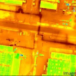
FAIRFAX, Virginia, USA / WILNSDORF, Germany, 26 July 2017 – Icaros Inc., a leading provider of aerial imaging software, is pleased to announce that version 5.1 of OneButton™ Standard and Professional image processing software for unmanned aerial systems (drones) contains advanced algorithms to process Thermal IR images from Radiometric microbolometer sensors.

Filed Under: Business, Earth Imaging - Remote Sensing, UAV/UAS Tagged With: icaros, imaging, sensor

Cool Tech! TerraPattern, open-source tool for discovering “patterns of interest”

May 31, 2016 By GISuser

Here’s some pretty nifty imaging technology that rolls in some slick image recognition and a ton of data! Enter TerraPattern.

Filed Under: Around the Web, Earth Imaging - Remote Sensing, Software, SPOTLIGHTS, Tips, Top Press Tagged With: imaging, Open Source, TerraPattern

Esri to Host Imaging and Mapping Forum at Esri User Conference

May 31, 2016 By GISuser

Industry Thought Leaders and Executives Gather for Innovation That Inspires Change

Filed Under: 2016 ESRIUC, Events, Featured Event, Top Press Tagged With: esriuc, event, imaging

Orbit GT showcases UAS Mapping Pro at Intergeo, Berlin

October 2, 2014 By GISuser

Orbit GeoSpatial Technologies will showcase “Orbit UAS Mapping Pro”, version 11.0, at Intergeo, Berlin, next week.

Filed Under: Earth Imaging - Remote Sensing, Events, Top Press, UAV/UAS Tagged With: imaging, intergeo, LiDAR, UAS

« Previous Page

Recent Industry News

The Future of Competitive Gaming: Why DMA Technology is the Ultimate Performance Edge

June 24, 2026 By GISuser

Milwaukee M18FHZ-0 Hackzall Reciprocating Saw – For hardcore cutting in a compact size

June 19, 2026 By GISuser

How Enterprises Are Using AI to Automate 80% of Customer Interactions With Voice Agents

June 16, 2026 By GISuser

Why On Cloud Shoes Are Worth the Price in Mexico

June 16, 2026 By GISuser

Hot News

State of Data Science Report – AI and Open Source at Work

HERE and AWS Collaborate on New HERE AI Mapping Solutions

Virtual Surveyor Adds Productivity Tools to Mid-Level Smart Drone Surveying Software Plan

Categories

Copyright gletham Communications 2015 - 2026

Go to mobile version