GIS user technology news

News, Business, AI, Technology, IOS, Android, Google, Mobile, GIS, Crypto Currency, Economics

  • Advertising & Sponsored Posts
    • Advertising & Sponsored Posts
    • Submit Press
  • PRESS
    • Submit PR
    • Top Press
    • Business
    • Software
    • Hardware
    • UAV News
    • Mobile Technology
  • FEATURES
    • Around the Web
    • Social Media Features
    • EXPERTS & Guests
    • Tips
    • Infographics
  • Blog
  • Events
  • Shop
  • Tradepubs
  • CAREERS
You are here: Home / Archives for icaros

Icaros and TeAx Announce an Integrated Drone Mapping Solution for Radiometric ThermalCapture (FLIR core) Sensors

July 26, 2017 By GISuser

Underground District Heating Pipeline - ThermalCapture with OneButton Post processing

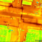
FAIRFAX, Virginia, USA / WILNSDORF, Germany, 26 July 2017 – Icaros Inc., a leading provider of aerial imaging software, is pleased to announce that version 5.1 of OneButton™ Standard and Professional image processing software for unmanned aerial systems (drones) contains advanced algorithms to process Thermal IR images from Radiometric microbolometer sensors.

Filed Under: Business, Earth Imaging - Remote Sensing, UAV/UAS Tagged With: icaros, imaging, sensor

Icaros Releases Version 5.0 of OneButton Drone Image Processing Software

May 15, 2017 By GISuser

FAIRFAX, Virginia, USA, 15 May 2017 – Icaros Inc., a leading provider of aerial imaging software, is pleased to announce the release of version 5.0 of OneButton™ Standard and Professional image processing software for unmanned aerial systems (drones). The 5.0 release contains a significant number of major new features and hundreds of other improvements, including a new […]

Filed Under: Software, UAV/UAS Tagged With: icaros, uav processing

Recent Industry News

Why Bathroom Renovation Services Often Change More Than Just the Bathroom

May 20, 2026 By GISuser

The Drift Between Early Notes and Final Case Files in Abuse-Related Legal Support

April 29, 2026 By GISuser

Aerial Surveys Int’l and Global Marketing Insights to Present GEOINT 2026 Workshop on Multi-Domain Geospatial Fusion for Automated Infrastructure Monitoring

April 24, 2026 By GISuser

Why Timing Matters More Than You Think With Spray Seal (And Why People Often Get It Slightly Wrong)

April 22, 2026 By GISuser

Hot News

State of Data Science Report – AI and Open Source at Work

HERE and AWS Collaborate on New HERE AI Mapping Solutions

Virtual Surveyor Adds Productivity Tools to Mid-Level Smart Drone Surveying Software Plan

Categories

Copyright gletham Communications 2015 - 2026

Go to mobile version