GIS user technology news

News, Business, AI, Technology, IOS, Android, Google, Mobile, GIS, Crypto Currency, Economics

  • Advertising & Sponsored Posts
    • Advertising & Sponsored Posts
    • Submit Press
  • PRESS
    • Submit PR
    • Top Press
    • Business
    • Software
    • Hardware
    • UAV News
    • Mobile Technology
  • FEATURES
    • Around the Web
    • Social Media Features
    • EXPERTS & Guests
    • Tips
    • Infographics
  • Blog
  • Events
  • Shop
  • Tradepubs
  • CAREERS
You are here: Home / Archives for * PRESS / Web Services

Esri Announces First-Round Winners of Small Nonprofit Organization Grant Initiative

November 22, 2022 By GISuser

Small Nonprofit Organizations Will Have Access to GIS Technology, Training, and Community Networking Resources

Filed Under: Business, Top Press, Web Services Tagged With: ESRI, non-profit

Mapping the Spread of #Coronavirus COVID-19 – Trusted Maps and Data

March 5, 2020 By GISuser

HERE Developer tracking Coronavirus COVID-19

This post has generated loads of activity and engagement via LinkedIn. The article discusses the coronavirus outbreak and delves into a look at some trusted map and data resources that are tracking the spread.

Filed Under: Around the Web, Emergency Response, THE EDITOR, Top Text Lead Story, Web Services Tagged With: coronavirus, covid19, health, Maps, opendata, webmaps

Cesium announces “Cesium Stories” a new app to easily create and share online geospatial presentations and story maps- no coding required

March 5, 2020 By GISuser

cesium

March 4, 2020 – PHILADELPHIA — Cesium™, the market leader in streaming 3D geospatial technology, today announced a new consumer-focused application built on Cesium ion™ – the company’s acclaimed geospatial mapping solution.

Filed Under: Software, Top Press, Web Services Tagged With: cesium, story maps

NORAD Tracks Santa program 2019

December 24, 2019 By GISuser

NORAD Tracks Santa program

As the North American Aerospace Defense Command conducts its primary mission of defending the homeland, it stands ready to continue its tradition of tracking Santa’s journey around the globe on Dec. 24.

Filed Under: Business, Top Text Lead Story, Web Services Tagged With: NORAD, santa

Concept3D Announces Boca Center as Latest Retail Location to Launch its Immersive Map Platform

July 23, 2019 By GISuser

Concept3D Announces Boca Center as Latest Retail Location to Launch its Immersive Map Platform

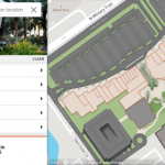
New Interactive Map Highlights Potential of Concept3D Platform to Showcase Retail, Malls, Restaurants and Hotels

Filed Under: Business, Web Services Tagged With: 3D, retail

Nexar Launches Live Map, Taking On Google Street View

July 21, 2019 By GISuser

Using billions of street level images from the Nexar network, Nexar Live Map paves the way for the future of digital mapping

Filed Under: Business, Web Services Tagged With: nexar, street view

RentSeeker.ca Announces New Verified Listings Feature

July 18, 2019 By GISuser

rent seeker

Canada’s Leading Apartment Finder Launches New Trust Tool Confirming Verification of Property Listings

Filed Under: Business, Web Services Tagged With: real estate

B.C Government Coroners Service Launches Interactive tool launched to help identify human remains

March 27, 2019 By GISuser

B.C Government Launches Interactive tool launched to help identify human remains

The BC Coroners Service has launched a new interactive tool displaying key information on active unidentified human remains cases in British Columbia, with an aim to generate new leads that will assist in closing these investigations.

Filed Under: Emergency Response, Web Services Tagged With: bc, coroner

Online Mapping Tool Reveals 500 Million Square Feet of Public Land Potentially Usable for Affordable Housing

March 14, 2019 By Editor

https://land.ccs.miami.edu/explore/parcels

Free online tool developed by the University of Miami with support from Citi aims to jump-start affordable housing development in Miami-Dade County by identifying underutilized public land.

Filed Under: Maps and Cartography, Web Services Tagged With: real estate

Maptiks Adds Integration to Esri

February 12, 2019 By GISuser

Maptiks Adds Integration to Esri

Integrations Include Story Maps, Additional ArcGIS Online Templates and Web App Builder

Filed Under: Software, Top Press, Top Text Lead Story, Web Services Tagged With: analytics, AppBuilder, arcgis, ESRI, webmap

Next Page »

Recent Industry News

The Complete Guide to Buying Xxxxxxxxl Size Cxx Clothing: Fit, Comfort and Style Tips 

March 16, 2026 By GISuser

What Is In-Home Disability Care and How It Works With Five Good Friends

March 9, 2026 By GISuser

Eagleview White Paper Warns: Geospatial Intelligence Is About to Change Forever

March 4, 2026 By GISuser

Hot News

State of Data Science Report – AI and Open Source at Work

HERE and AWS Collaborate on New HERE AI Mapping Solutions

Categories

Copyright Spatial Media LLC 2003 - 2015

Go to mobile version