GIS user technology news

News, Business, AI, Technology, IOS, Android, Google, Mobile, GIS, Crypto Currency, Economics

  • Advertising & Sponsored Posts
    • Advertising & Sponsored Posts
    • Submit Press
  • PRESS
    • Submit PR
    • Top Press
    • Business
    • Software
    • Hardware
    • UAV News
    • Mobile Technology
  • FEATURES
    • Around the Web
    • Social Media Features
    • EXPERTS & Guests
    • Tips
    • Infographics
  • Blog
  • Events
  • Shop
  • Tradepubs
  • CAREERS
You are here: Home / * PRESS / Web Services / B.C Government Coroners Service Launches Interactive tool launched to help identify human remains

B.C Government Coroners Service Launches Interactive tool launched to help identify human remains

March 27, 2019 By GISuser

The BC Coroners Service has launched a new interactive tool displaying key information on active unidentified human remains cases in British Columbia, with an aim to generate new leads that will assist in closing these investigations.
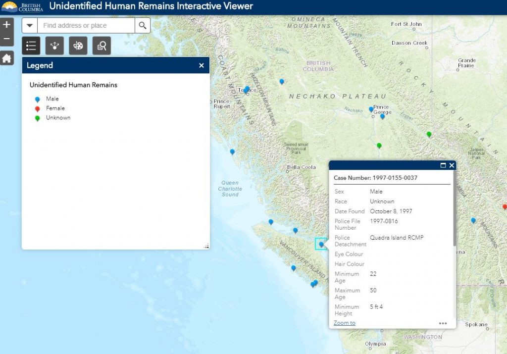
B.C Government Launches Interactive tool launched to help identify human remains

The unidentified human remains (UHR) interactive viewer is a web-mapping application containing spatial, temporal and statistical information on every active, unsolved UHR investigation in the province. There are currently just under 200 unsolved and active cases involving unidentified human remains in B.C. Most of these involve cold cases, with the earliest dating back to 1953.

The UHR interactive viewer was developed by Ian Charlton, a spatial information analyst with the BC Coroners Service’s Special Investigations Unit. It is hosted on B.C.’s map hub. The viewer provides a visual overview of the approximate location where the remains were found, case numbers for contact purposes and a summary of the key information related to each unresolved case in B.C.

“By reaching out and engaging members of the public with the launch of this innovative tool, it’s our hope to gain new investigative leads that will lead to the identification of these unidentified individuals and bring closure to their families,” said Lisa Lapointe, chief coroner.

Anyone with information or questions about any of the investigations displayed on the UHR interactive viewer should contact the Special Investigations Unit using the case number provided in the viewer at: BCCS.SIU@gov.bc.ca

Source: BC Government

See also the BC Map Hub for more data 

Filed Under: Emergency Response, Web Services Tagged With: bc, coroner

Top Press

The Global Expansion of Aueshah: A New Era of High Jewelry

April 11, 2026 By GISuser

KARACHI, PAKISTAN. The international luxury market is experiencing a profound shift. Consumers are increasingly rejecting mass-produced goods in favor of rarity, authenticity, and emotional depth. … [Read More...]

State of Data Science Report – AI and Open Source at Work

September 10, 2025 By GISuser

AI and Open Source at Work … [Read More...]

Topcon Announces Landmark Expansion of Topnet Live Network Across USA

January 26, 2025 By GISuser

LIVERMORE, Calif.---Topcon Positioning Systems has announced a significant expansion of its Topnet Live reference station network, introducing 200 new geodetic stations strategically positioned across … [Read More...]

Space Flight Laboratory (SFL) Announces Launch and Deployment of NorSat-4 Maritime Monitoring Microsatellite

January 19, 2025 By GISuser

Seventh Satellite Developed by SFL for Norway … [Read More...]

HERE and BMW Group extend partnership on AI-powered mapping system

January 8, 2025 By GISuser

HERE and BMW Group extend partnership on AI-powered mapping system for automated driving and enhanced road safety … [Read More...]

Canadian-Built RoadEng 12 Uses AI to Find the Best Location for New Resource and Rural Roads

October 17, 2026 By GISuser

Vancouver, BC, Canada, October 15, 2026 – North Vancouver-based Softree Technical Systems today released RoadEng Version 12, used in more than 75 countries to locate and design … [Read More...]

Beyond the Map: How AI Image and Video Generation Is Changing Geospatial Communication

October 14, 2026 By GISuser

Ask anyone who has shipped a GIS project what the hardest part was, and the answer is rarely the spatial analysis. It is almost always the communication. A site suitability … [Read More...]

From Maternity to Everyday Wear: Building a Wardrobe That Grows With You

October 14, 2026 By GISuser

When I think about maternity clothing, I feel the biggest mistake is buying too many things at once. During pregnancy, your body keeps changing, and something that fits well today … [Read More...]

eMMC 5.1 Explained: Features, Performance, and Applications in Modern Devices

October 14, 2026 By GISuser

Storage technology is an essential part of modern computing, influencing how devices store information, launch applications, and manage everyday workloads. Although … [Read More...]

SFL Missions Inc. Confirms Successful Deployment of Two GHGSat Greenhouse Gas Monitoring Microsatellites

October 3, 2026 By GISuser

TORONTO, Ontario, Canada, 2 October 2026 – SFL Missions Inc. confirms the successful launch and deployment of the GHGSat-C18 (Eleanor) and GHGSat-C19 (Aidan) commercial greenhouse … [Read More...]

Copyright gletham Communications 2015 - 2026

Go to mobile version